

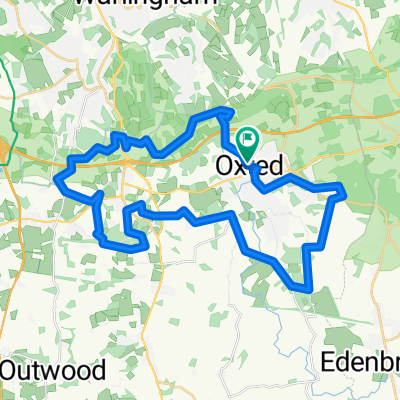
A 14 mile North Downs circular route, including Pilgrims Way, Cycle Route 21, on and off road.
A cycling route starting in Oxted, England, United Kingdom.
Overview
About this route
A moderate route starting from Central Way, Oxted heading clockwise from Barrow Green Road climbing Gangers Hill towards North Downs Golf Club. Continuing North towards Woldingham and Chelsham, on and off road, bridal tracks and narrow country lanes. Eventually heading North East to the 16th Century White Bear Pub in Fickleshole and then South back towards the Ridge. Continue South and across the M25 downhill along Chalkpit Lane back towards Central Way. Some steep elevations along the route may be more challenging but there are alternative options to divert along less steeper routes.
- 2 h 4 min
- Duration
- 22.1 km
- Distance
- 348 m
- Ascent
- 347 m
- Descent
- 10.7 km/h
- Avg. speed
- ---
- Avg. speed
Route quality
Waytypes & surfaces along the route
Waytypes
Road
9.8 km
(44 %)
Quiet road
6.4 km
(29 %)
Surfaces
Paved
7.2 km
(33 %)
Unpaved
2.6 km
(12 %)
Asphalt
7.2 km
(33 %)
Gravel
2 km
(9 %)
Continue with Bikemap
Use, edit, or download this cycling route
You would like to ride A 14 mile North Downs circular route, including Pilgrims Way, Cycle Route 21, on and off road. or customize it for your own trip? Here is what you can do with this Bikemap route:
Free features
- Save this route as favorite or in collections
- Copy & plan your own version of this route
- Sync your route with Garmin or Wahoo
Premium features
Free trial for 3 days, or one-time payment. More about Bikemap Premium.
- Navigate this route on iOS & Android
- Export a GPX / KML file of this route
- Create your custom printout (try it for free)
- Download this route for offline navigation
Discover more Premium features.
Get Bikemap PremiumFrom our community
Other popular routes starting in Oxted
 Oxted Edenbridge cycle
- Distance
- 26.4 km
- Ascent
- 230 m
- Descent
- 230 m
- Location
- Oxted, England, United Kingdom
 Flat loop - Oxted
- Distance
- 16.1 km
- Ascent
- 88 m
- Descent
- 88 m
- Location
- Oxted, England, United Kingdom
 Oxted to Wrotham South route
- Distance
- 40.4 km
- Ascent
- 847 m
- Descent
- 957 m
- Location
- Oxted, England, United Kingdom
 plan oxted
- Distance
- 36.6 km
- Ascent
- 481 m
- Descent
- 476 m
- Location
- Oxted, England, United Kingdom
 Oxted to crowborough
- Distance
- 46.3 km
- Ascent
- 513 m
- Descent
- 413 m
- Location
- Oxted, England, United Kingdom
 Godstone 50km
- Distance
- 50.1 km
- Ascent
- 863 m
- Descent
- 863 m
- Location
- Oxted, England, United Kingdom
 Oxted to Eastbourne shorter
- Distance
- 110.6 km
- Ascent
- 676 m
- Descent
- 776 m
- Location
- Oxted, England, United Kingdom
 Oxted Loop via Ide Hill
- Distance
- 53.5 km
- Ascent
- 294 m
- Descent
- 299 m
- Location
- Oxted, England, United Kingdom
Open it in the app