
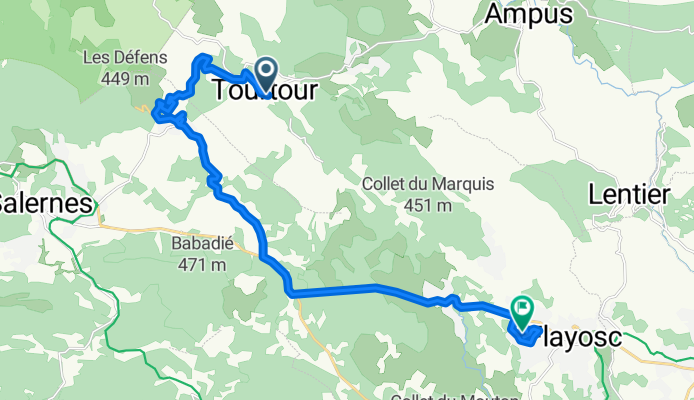
De 3 Place des Ormeaux, Tourtour à 353 Chemin du Ginesté, Flayosc
A cycling route starting in Villecroze, Provence-Alpes-Côte d'Azur Region, France.
Overview
About this route
- 1 h 16 min
- Duration
- 21.9 km
- Distance
- 263 m
- Ascent
- 563 m
- Descent
- 17.2 km/h
- Avg. speed
- ---
- Avg. speed
Route quality
Waytypes & surfaces along the route
Waytypes
Busy road
10 km
(46 %)
Road
7.7 km
(35 %)
Surfaces
Paved
11.2 km
(51 %)
Asphalt
11.2 km
(51 %)
Undefined
10.6 km
(49 %)
Continue with Bikemap
Use, edit, or download this cycling route
You would like to ride De 3 Place des Ormeaux, Tourtour à 353 Chemin du Ginesté, Flayosc or customize it for your own trip? Here is what you can do with this Bikemap route:
Free features
- Save this route as favorite or in collections
- Copy & plan your own version of this route
- Sync your route with Garmin or Wahoo
Premium features
Free trial for 3 days, or one-time payment. More about Bikemap Premium.
- Navigate this route on iOS & Android
- Export a GPX / KML file of this route
- Create your custom printout (try it for free)
- Download this route for offline navigation
Discover more Premium features.
Get Bikemap PremiumFrom our community
Other popular routes starting in Villecroze
 Tourtour to Aups
- Distance
- 51.2 km
- Ascent
- 1,277 m
- Descent
- 1,279 m
- Location
- Villecroze, Provence-Alpes-Côte d'Azur Region, France
 Tour Tour -road circuite with tour of Grimaldi tower
- Distance
- 48.2 km
- Ascent
- 704 m
- Descent
- 703 m
- Location
- Villecroze, Provence-Alpes-Côte d'Azur Region, France
 Provence_Cotignac
- Distance
- 46.2 km
- Ascent
- 660 m
- Descent
- 660 m
- Location
- Villecroze, Provence-Alpes-Côte d'Azur Region, France
 Le villages historiques du Var 2007
- Distance
- 88.9 km
- Ascent
- 724 m
- Descent
- 760 m
- Location
- Villecroze, Provence-Alpes-Côte d'Azur Region, France
 LA BIGUE, por Villecroze
- Distance
- 13 km
- Ascent
- 519 m
- Descent
- 65 m
- Location
- Villecroze, Provence-Alpes-Côte d'Azur Region, France
 23) Villecroze - Saint Raphaël
- Distance
- 72 km
- Ascent
- 299 m
- Descent
- 545 m
- Location
- Villecroze, Provence-Alpes-Côte d'Azur Region, France
 Route 11
- Distance
- 132.8 km
- Ascent
- 1,635 m
- Descent
- 1,548 m
- Location
- Villecroze, Provence-Alpes-Côte d'Azur Region, France
 Etapa 087B (Villecroze - Dauphin)
- Distance
- 142.5 km
- Ascent
- 1,537 m
- Descent
- 1,431 m
- Location
- Villecroze, Provence-Alpes-Côte d'Azur Region, France
Open it in the app