

Carrera MTB Chupacabras 100kms Juarez, Mexico.
A cycling route starting in Ciudad Juárez, Chihuahua, Mexico.
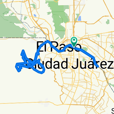
Overview
About this route
Consiste en recorrer 100 kilómetros en bicicleta de montaña y es la primera carrera de ciclismo de montaña que se desarrolla en el lado mexicano de la frontera con Estados Unidos a lo largo del Río Bravo y la sierra de Juárez.
Cuenta con la participación de ciclistas locales, de todas las latitudes de México y de muchos otros países para ser parte del mayor reto deportivo extremo en México.
Es la única carrera que se corre en zona desértica bajo condiciones extremas de terreno y clima y realiza anualmente en el segundo sábado del mes de Octubre en Cd. Juárez, Chih , México.
- -:--
- Duration
- 102.2 km
- Distance
- 691 m
- Ascent
- 691 m
- Descent
- ---
- Avg. speed
- ---
- Avg. speed
Route highlights
Points of interest along the route
Point of interest after 42.6 km
<b>Liebres Trail (3750 mts)</b> <br> <b>Nombre:</b>Liebres Trail <br> <b>Creada/Adoptada por:</b> Equipo Ciclismo ITCJ </b> <br> <b>Utilizacion:</b>Desde Edicion 2012 hasta la fecha. <br> <b>Distancia:</b>3750 mts <br> <b>Detalle:</b>3750 mts de double track que faldea el cerro.<br> <b>Dificultad:</b> Baja <br> <b>Descripcion:</b>Trail Ideado para hacer para hacer mas divertido el trayecto inicial en la montaña.
Photo after 48.1 km
Check Point # 3
Point of interest after 48.7 km
<b>Oreja del Coyote (3,740 mts)</b> <br> <b>Nombre:</b>Oreja del Coyote <br> <b>Creada/Adoptada por:</b> Chupacabras / Chambelanes </b> <br> <b>Utilizacion:</b> Desde Edicion 2011 hasta la fecha. <br> <b>Distancia:</b> 3,740 mts <br> <b>Detalle:</b> 2,540 mts de camino jeepero, de Arroyo 1,200 mts de Arroyo arenoso en subida <br> <b>Dificultad:</b> Mediana <br> <b>Descripcion:</b> Inicia despues de los ponchados 2.
Point of interest after 49.4 km
<b>Arroyo Coyote (700 mts)</b> <br> <b>Nombre:</b>Arroyo Coyote <br> <b>Creada/Adoptada por:</b> Chupacabras / Chambelanes </b> <br> <b>Utilizacion:</b> Desde Edicion 2011 hasta la fecha. <br> <b>Distancia:</b> 550 mts <br> <b>Detalle:</b>Arroyo arenoso en subida y con gran cantidad de huecos que dificultan el transito. <br> <b>Dificultad:</b> Mediana <br> <b>Descripcion:</b> Arroyo arenoso en subida y con gran cantidad de huecos que dificultan el transito.
Point of interest after 50 km
<b>El Nido (550 mts)</b> <br> <b>Nombre:</b>El Nido <br> <b>Creada/Adoptada por:</b> Los chambelanes/Chupacabras </b> <br> <b>Utilizacion:</b> Desde Edicion 2011 hasta la fecha. <br> <b>Distancia:</b>550 mts <br> <b>Detalle:</b>550 mts de subida por un single track.<br> <b>Dificultad:</b>Baja <br> <b>Descripcion:</b>Despues de la subida se llega al mirador, donde se logra vistas panoramicas espectaculares, y se recorre por una bajada un poco tecnica asi el interior del cerrito lo que asemeja un nido, por lo cual se gano el nombre.
Point of interest after 52 km
<b>La Domadora (2,000 mts)</b> <br> <b>Nombre:</b>La Domadora <br> <b>Creada/Adoptada por:</b> Los Chambelanes/Chupacabras </b> <br> <b>Utilizacion:</b> Desde Edicion 2011 hasta la fecha. <br> <b>Distancia:</b> 2,000 mts <br> <b>Detalle:</b>2,000 mts de single track con mutiples cruces por arroyos<br> <b>Dificultad:</b>Baja <br> <b>Descripcion:</b>Debido a los mutiples cruces por arroyos se torna agotadoras y muy demandantes para lograr cruzarlos.
Point of interest after 53.8 km
Punto de Abastecimiento #3
Photo after 53.9 km
Check point # 4
Point of interest after 54.2 km
<b>El Kamikaze (2,420 mts)</b> <br> <b>Nombre:</b>El Kamikaze <br> <b>Creada/Adoptada por:</b> Los Chambelanes/Chupacabras/Powershots </b> <br> <b>Utilizacion:</b>Desde Edicion 2011 hasta la fecha. <br> <b>Distancia:</b>2,420 mts <br> <b>Detalle:</b>2,420 mts de bajada con mediana grado de dificultad tecnica.<br> <b>Dificultad:</b> Media <br> <b>Descripcion:</b>2,420 mts de bajada tecnica. debido a la gran cantidad de arroyo que lo cruzan se correr el riesgo de caer en ellos.
Point of interest after 56.4 km
<b>Los Cascabeles (1,500 mts)</b> <br> <b>Nombre:</b>Los Cascabeles <br> <b>Creada/Adoptada por:</b> Powershots/Chambelanes/Chupacabras </b> <br> <b>Utilizacion:</b>Desde Edicion 2011 hasta la fecha. <br> <b>Distancia:</b>1,500 mts <br> <b>Detalle:</b>1,000 mts de single track <br> <b>Dificultad:</b> Media <br> <b>Descripcion:</b>1000 mts de single track en caminos jeeperos se considera como un descanso y oportunidad de recuperarse.
Point of interest after 58.5 km
<b>Transformers Trail (1,200 mts)</b> <br> <b>Nombre:</b>Transformers Trail <br> <b>Creada/Adoptada por:</b> Los Transformers Futbol Team / Los Chambelanes/Chupacabras/Powershots </b> <br> <b>Utilizacion:</b>Desde Edicion 2011 hasta la fecha. <br> <b>Distancia:</b>1,200 mts <br> <b>Detalle:</b>1,200 mts de single track de subida y bajadas en single track con trampas de arenas.<br> <b>Dificultad:</b> Media <br> <b>Descripcion:</b>1,200 mts de single track con gran cantidad de bancos de arena.
Photo after 58.8 km
Check Point #5
Point of interest after 59.3 km
<b>Kamaleones Trail (500 mts)</b> <br> <b>Nombre:</b>Kamaleones Trail <br> <b>Creada/Adoptada por:</b> Kamaleones/Chupacabras </b> <br> <b>Utilizacion:</b>Desde Edicion 2011 hasta la fecha. <br> <b>Distancia:</b>500 mts <br> <b>Detalle:</b>500 mts de single track de subida y bajadas<br> <b>Dificultad:</b> Media <br> <b>Descripcion:</b>single Track con subidas y bajadas faldeando otra de los cerros.
Point of interest after 59.8 km
El Caracol
Point of interest after 60.1 km
Rafitas tummy
Point of interest after 61.2 km
La A. A.
Point of interest after 64.7 km
<b>El Castrellon</b> <br> <b>Nombre:</b>El Castrellon<br> <b>Creada/Adoptada por:</b> Los Chupacabras </b> <br> <b>Utilizacion:</b> Desde Edicion 1996 hasta la fecha. <br> <b>Distancia:</b> <br> <b>Detalle:</b>Punto Emblematico de la pista<br> <b>Dificultad:</b>Baja <br> <b>Descripcion:</b>Debido a que se trata de una pendiente ligera pero muy larga es muy desgastante y tiene un final muy pesado.
Point of interest after 67 km
<b>Los Dragones (4,500 mts)</b> <br> <b>Nombre:</b>Los dragones <br> <b>Creada/Adoptada por:</b> Chupacabras </b> <br> <b>Utilizacion:</b>Desde Edicion 2008 hasta la fecha. <br> <b>Distancia:</b>4,500 mts <br> <b>Detalle:</b>3,000 mts de single track de subida y bajadas y 1,500 mts de bajada con mediana grado de dificultad tecnica, muy panoramica ya que se logra ver casi toda la bajada desde la casa de Don Rayo.<br> <b>Dificultad:</b> Media <br> <b>Descripcion:</b>20 mts de bajada con alto grado de dificultad tecnica. debido a la gran cantidad de piedras sueltas, se corre el riesgo de derrapar.
Point of interest after 68.4 km
Arroyo Dragones
Photo after 68.4 km
Check point #6
Point of interest after 70 km
Karina / Laredos Trail
Point of interest after 72 km
<b>Escalones de King Kong (785 mts)</b> <br> <b>Nombre:</b> Escalones de King Kong <br> <b>Creada/Adoptada por:</b> Chupacabras <br> <b>Utilizacion:</b> Desde Edicion 2003 a la fecha. <br> <b>Distancia:</b> 785 mts <br> <b>Detalle:</b> 785 mts de subida muy Tecnica. <br> <b>Dificultad:</b> Alta <br> <b>Descripcion:</b> Inicia despues de la plaza de King Kong.
Point of interest after 72.6 km
<b>TNT (640 mts)</b> <br> <B>Nombre:</b> TNT (Tinker's Nasty Trail) <br> <b>Creada/Adoptada por:</b> Chupacabras. <br> <b>Utilizacion:</b> Desde Edicion 2003 hasta la fecha. <br> <b>Distancia:</b> 640 mts <br> <b>Detalle:</b> 640 mts de Bajada muy Tecnica la ultima parte. <br> <b>Dificultad:</b> Alta <br> <b>Descripcion:</b> Inicia despues de la los escalones de King Kong y termina justo antes de la ultima parte de la bajada del diablo.
Point of interest after 72.8 km
<b>Bajada del Diablo (40 mts)</b> <br> <b>Nombre:</b> Bajada del Diablo <br> <b>Creada/Adoptada por:</b> Chupacabras </b> <br> <b>Utilizacion:</b> Desde Edicion 2003 hasta la fecha. <br> <b>Distancia:</b> 40 mts <br> <b>Detalle:</b> 40 mts de bajada con alto grado de dificultad tecnica solo los primeros lugares logran bajarla arriba de la bici, se etiqueta con 3 flechas haca abajo y letreros de STOP<br> <b>Dificultad:</b> Alta <br> <b>Descripcion:</b> Es de los lugares tradicionales y emblematicos de la carrera. Se recomienda mucha precaucion al transitar por ella.
Point of interest after 73.1 km
<b>Arroyo del Diablo (740 mts)</b> <br> <b>Nombre:</b> Arroyo del Diablo <br> <b>Creada/Adoptada por:</b> Chupacabras </b> <br> <b>Utilizacion:</b> Desde Edicion 2003 hasta la fecha. <br> <b>Distancia:</b> 740 mts <br> <b>Detalle:</b> 150 mts de Arroyo 490 mts de subida <br> <b>Dificultad:</b> Mediana Alta <br> <b>Descripcion:</b> Inicia despues de la la bajada del Diablo, es un tramo lleno de arena y piedras grandes de dificil transito.
Photo after 73.5 km
Check Point # 7
Point of interest after 75.1 km
<b>Los Chambelanes</b> <br> <b>Nombre:</b>Los Chambelanes<br> <b>Creada/Adoptada por:</b> Los Chambelanes / Chupacabras </b> <br> <b>Utilizacion:</b> Desde Edicion 2009 hasta la fecha. <br> <b>Distancia:</b> 1,500 mts <br> <b>Detalle:</b>subida con un aparte muy tecnica y demandante<br> <b>Dificultad:</b>Media <br> <b>Descripcion:</b>Se trata de una pendiente pronunciada.
Point of interest after 75.7 km
<b>Bajada de la Bestia (70 mts)</b> <br> <b>Nombre:</b> Bajada de la Bestia <br> <b>Creada/Adoptada por:</b> Los Chambelanes </b> <br> <b>Utilizacion:</b> Desde Edicion 2009 hasta la fecha. <br> <b>Distancia:</b> 70 mts <br> <b>Detalle:</b> 70 mts de bajada tecnica <br> <b>Dificultad:</b> Mediana Alta <br> <b>Descripcion:</b> Inicia despues del Puerto Chambelanes, se recomienda precaucion ya que tiene una swith back muy pronunciado el cual dio el nombre a la misma, por su alto nivel de tecnica para poder cruzarlo.
Photo after 76 km
Check point #8
Point of interest after 77.3 km
El Arbolito
Point of interest after 78.5 km
El Alien Track
Point of interest after 79.6 km
<b>La ruleta #1 (1,120 mts)</b> <br> <b>Nombre:</b>La Ruleta #1 <br> <b>Creada/Adoptada por:</b> Chupacabras </b> <br> <b>Utilizacion:</b>Desde Edicion 2009 hasta la fecha. <br> <b>Distancia:</b>1,120 mts <br> <b>Detalle:</b>1,120 mts de bajada con alto grado de dificultad tecnica.<br> <b>Dificultad:</b> Media <br> <b>Descripcion:</b>1,120 mts de bajada con alto grado de dificultad tecnica. debido a la gran cantidad de piedras sueltas, se corre el riesgo de derrapar.
Point of interest after 80.3 km
<b>La ruleta #2 (500 mts)</b> <br> <b>Nombre:</b>La Ruleta #2 <br> <b>Creada/Adoptada por:</b> Chupacabras </b> <br> <b>Utilizacion:</b>Desde Edicion 2009 hasta la fecha. <br> <b>Distancia:</b>500 mts <br> <b>Detalle:</b>500 mts de bajada con alto grado de dificultad tecnica.<br> <b>Dificultad:</b> Media <br> <b>Descripcion:</b>500 mts de bajada con alto grado de dificultad tecnica.abada en un arroyo arenoso con u brinco muy grande y una vuelta a la izquierda.
Photo after 80.8 km
Check popint #9
Point of interest after 80.8 km
Point of interest after 81.4 km
<b>La Bufadora (1,400 mts)</b> <br> <b>Nombre:</b>La Bufadora <br> <b>Creada/Adoptada por:</b> Chupacabras </b> <br> <b>Utilizacion:</b> Desde Edicion 2009 hasta la fecha. <br> <b>Distancia:</b>1,400 mts <br> <b>Detalle:</b>1,400 mts de subida por un camino jeepero, requiere de tener condicion y tecnica para lograr conquistarla<br> <b>Dificultad:</b>Baja <br> <b>Descripcion:</b>Es la prueba definitiva, despues de 85 kms el enfrentarse a la bufadora es todo un reto de condicion, inicia con una subida muy ligera y termina en un caracol ascendente.
Point of interest after 83.3 km
Punto de Abastecimiento Don Rayo
Point of interest after 83.3 km
Point of interest after 83.4 km
<b>Casa de Don Rayo (40 mts)</b> <br> <b>Nombre:</b>Casa de Don Rayo <br> <b>Creada/Adoptada por:</b> Chupacabras </b> <br> <b>Utilizacion:</b>Desde Edicion 2004 hasta la fecha. <br> <b>Distancia:</b>40 mts <br> <b>Detalle:</b>40 mts de camino jeepero.<br> <b>Dificultad:</b> Baja <br> <b>Descripcion:</b>Casa de Don Rayo lugar emblematico de la carrera asi como lugar tipico de entrenamiento, Estacionamiento para espectadores, Abastecimiento de hidratacion gratuito super completo. para participantes, espectadores soporte y todo el publico en general. Punto se soporte medico y ambulancias
Point of interest after 87.4 km
<b>Cristo de Curiel (km40)</b> <br> <b>Nombre:</b>Cristo de Curiel <br> <b>Creada/Adoptada por:</b> Chupacabras </b> <br> <b>Utilizacion:</b>Desde Edicion 1994 hasta la fecha. <br> <b>Distancia:</b>Ubicada enel Km 40 <br> <b>Detalle:</b> Area emblematica de la Carrera, punto de referencia principal <br> <b>Dificultad:</b> Baja<br> <b>Descripcion:</b> Es una pequeña loma en la cual se tiene Al Cristo de Curiel , es practicamente la mitad del recorrido y es donde inicia el reto mas dificil para los participantes de Chupacabras. Asi mismo es una amplia area de estacionamiento para el publico espectador Abasteciomiento completo para los participantes.
Continue with Bikemap
Use, edit, or download this cycling route
You would like to ride Carrera MTB Chupacabras 100kms Juarez, Mexico. or customize it for your own trip? Here is what you can do with this Bikemap route:
Free features
- Save this route as favorite or in collections
- Copy & plan your own version of this route
- Sync your route with Garmin or Wahoo
Premium features
Free trial for 3 days, or one-time payment. More about Bikemap Premium.
- Navigate this route on iOS & Android
- Export a GPX / KML file of this route
- Create your custom printout (try it for free)
- Download this route for offline navigation
Discover more Premium features.
Get Bikemap PremiumFrom our community
Other popular routes starting in Ciudad Juárez
 Carrera MTB Chupacabras 2013 100kms Juarez, Mexico Salida en la X
- Distance
- 99.5 km
- Ascent
- 675 m
- Descent
- 675 m
- Location
- Ciudad Juárez, Chihuahua, Mexico
 Paseo Mosketeroz 1
- Distance
- 28.2 km
- Ascent
- 93 m
- Descent
- 101 m
- Location
- Ciudad Juárez, Chihuahua, Mexico
 Carrera MTB Chupacabras 2015 100kms Juarez, Mexico.
- Distance
- 98.3 km
- Ascent
- 657 m
- Descent
- 655 m
- Location
- Ciudad Juárez, Chihuahua, Mexico
 Carrera MTB Chupacabras 2013 100kms Juarez, Mexico Salida en la X
- Distance
- 99.3 km
- Ascent
- 638 m
- Descent
- 638 m
- Location
- Ciudad Juárez, Chihuahua, Mexico
 Carrera MTB Chupacabritas Infantil B Ciudad, Juarez, Mexico
- Distance
- 9.4 km
- Ascent
- 107 m
- Descent
- 110 m
- Location
- Ciudad Juárez, Chihuahua, Mexico
 trepa
trepa- Distance
- 27 km
- Ascent
- 433 m
- Descent
- 439 m
- Location
- Ciudad Juárez, Chihuahua, Mexico
 "All Start here". MTB Race Octubre 23, 2011
- Distance
- 43.6 km
- Ascent
- 645 m
- Descent
- 645 m
- Location
- Ciudad Juárez, Chihuahua, Mexico
 De Calle Ramón Rayón 306, Juárez a Mimbrera 9719, Ciudad Juárez
- Distance
- 4.4 km
- Ascent
- 26 m
- Descent
- 0 m
- Location
- Ciudad Juárez, Chihuahua, Mexico
Open it in the app