
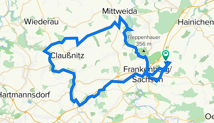
tour 210704 zschopau- und chemnitztal
A cycling route starting in Frankenberg, Saxony, Germany.
Overview
About this route
Start in Dittersbach, über die Lützelhöhe Richtung Hammertal/Mühlbachtal durch das ehem. Landesgartenschaugelände und über die Zschopau nach Niederlichtenau. Über Oberlichtenau nach Chemnitz-Glösa, durch den Sechsruthenwald hinunter ins Chemnitztal. Der alten Bahntrasse folgend bis Diethensdorf und durch den Ort wieder hoch in den Königshainer Wald. Von da über Altmittweida und den Schweizerwald ins Zschopautal. Über Sachsenburg entlang der Zschopau wieder nach Frankenberg und zurück durch das Lützeltal nach Dittersbach.
- -:--
- Duration
- 59.2 km
- Distance
- 409 m
- Ascent
- 410 m
- Descent
- ---
- Avg. speed
- 357 m
- Avg. speed

Route quality
Waytypes & surfaces along the route
Waytypes
Quiet road
24.4 km
(41 %)
Track
12 km
(20 %)
Surfaces
Paved
42 km
(71 %)
Unpaved
11.8 km
(20 %)
Asphalt
31.6 km
(53 %)
Paving stones
6.9 km
(12 %)
Continue with Bikemap
Use, edit, or download this cycling route
You would like to ride tour 210704 zschopau- und chemnitztal or customize it for your own trip? Here is what you can do with this Bikemap route:
Free features
- Save this route as favorite or in collections
- Copy & plan your own version of this route
- Sync your route with Garmin or Wahoo
Premium features
Free trial for 3 days, or one-time payment. More about Bikemap Premium.
- Navigate this route on iOS & Android
- Export a GPX / KML file of this route
- Create your custom printout (try it for free)
- Download this route for offline navigation
Discover more Premium features.
Get Bikemap PremiumFrom our community
Other popular routes starting in Frankenberg
 Hainichen
- Distance
- 28.2 km
- Ascent
- 331 m
- Descent
- 334 m
- Location
- Frankenberg, Saxony, Germany
 Männertagsrunde 2019
- Distance
- 77.8 km
- Ascent
- 607 m
- Descent
- 608 m
- Location
- Frankenberg, Saxony, Germany
 Hetzdorfer Viadukt über Ranis
- Distance
- 53.6 km
- Ascent
- 728 m
- Descent
- 726 m
- Location
- Frankenberg, Saxony, Germany
 Frankenberg - Hainichen - Oberschöna - Altenhain
- Distance
- 57 km
- Ascent
- 531 m
- Descent
- 489 m
- Location
- Frankenberg, Saxony, Germany
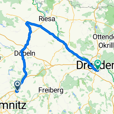 Frankenberg - Riesa - Dresden
- Distance
- 104.3 km
- Ascent
- 338 m
- Descent
- 511 m
- Location
- Frankenberg, Saxony, Germany
 Rund um Frankenberg 40,0km
- Distance
- 39.7 km
- Ascent
- 330 m
- Descent
- 367 m
- Location
- Frankenberg, Saxony, Germany
 Am Mühlberg, Frankenberg/Sachsen nach Marienberger Straße, Großrückerswalde
- Distance
- 45.2 km
- Ascent
- 1,014 m
- Descent
- 688 m
- Location
- Frankenberg, Saxony, Germany
 von Frankenberg nach Flöha - von Frankenberg nach Flöha
- Distance
- 12.9 km
- Ascent
- 362 m
- Descent
- 364 m
- Location
- Frankenberg, Saxony, Germany
Open it in the app