

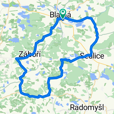
Okruh: Záboří
A cycling route starting in Blatná, Jihočeský kraj, Czechia.
Overview
About this route
Záboří - Čekanice - Lažany - Doubravice - Nahošín - Bratronice - Záboří
- -:--
- Duration
- 13.3 km
- Distance
- 135 m
- Ascent
- 134 m
- Descent
- ---
- Avg. speed
- 557 m
- Avg. speed
Route quality
Waytypes & surfaces along the route
Waytypes
Road
9.2 km
(69 %)
Quiet road
4.1 km
(31 %)
Undefined
0 km
(<1 %)
Continue with Bikemap
Use, edit, or download this cycling route
You would like to ride Okruh: Záboří or customize it for your own trip? Here is what you can do with this Bikemap route:
Free features
- Save this route as favorite or in collections
- Copy & plan your own version of this route
- Sync your route with Garmin or Wahoo
Premium features
Free trial for 3 days, or one-time payment. More about Bikemap Premium.
- Navigate this route on iOS & Android
- Export a GPX / KML file of this route
- Create your custom printout (try it for free)
- Download this route for offline navigation
Discover more Premium features.
Get Bikemap PremiumFrom our community
Other popular routes starting in Blatná
 ČP Blatná
- Distance
- 163.3 km
- Ascent
- 719 m
- Descent
- 716 m
- Location
- Blatná, Jihočeský kraj, Czechia
 Pumptrack Blatná
- Distance
- 0.4 km
- Ascent
- 4 m
- Descent
- 4 m
- Location
- Blatná, Jihočeský kraj, Czechia
 Katovice, Novosedly, Velké Hydčice
- Distance
- 63 km
- Ascent
- 646 m
- Descent
- 643 m
- Location
- Blatná, Jihočeský kraj, Czechia
 Sedlice, Třebohostice, Mečichov
- Distance
- 40.3 km
- Ascent
- 351 m
- Descent
- 351 m
- Location
- Blatná, Jihočeský kraj, Czechia
 Lom, Čimelice, Myštice
- Distance
- 56.9 km
- Ascent
- 400 m
- Descent
- 400 m
- Location
- Blatná, Jihočeský kraj, Czechia
 Blatná-Třemšín-Hadí rybník - 85 km
- Distance
- 77.5 km
- Ascent
- 651 m
- Descent
- 651 m
- Location
- Blatná, Jihočeský kraj, Czechia
 z Buzic přes Chloumek-Rožmitál-Hvoždany-a zpátky
- Distance
- 83.6 km
- Ascent
- 537 m
- Descent
- 537 m
- Location
- Blatná, Jihočeský kraj, Czechia
 Zavisin-Pb
- Distance
- 28.6 km
- Ascent
- 319 m
- Descent
- 303 m
- Location
- Blatná, Jihočeský kraj, Czechia
Open it in the app