

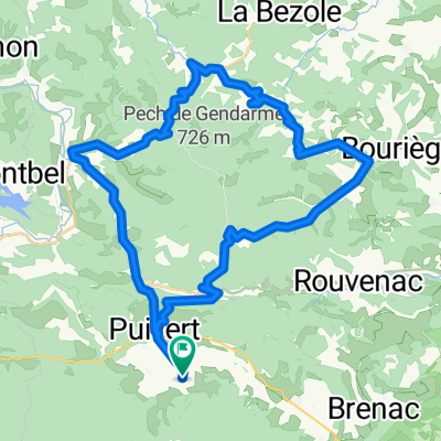
TDP - ETAPE 11
A cycling route starting in Chalabre, Languedoc-Roussillon-Midi-Pyrénées, France.
Overview
About this route
- -:--
- Duration
- 68.3 km
- Distance
- 1,865 m
- Ascent
- 1,168 m
- Descent
- ---
- Avg. speed
- 1,648 m
- Avg. speed
Route quality
Waytypes & surfaces along the route
Waytypes
Busy road
25.6 km
(38 %)
Road
24.4 km
(36 %)
Surfaces
Paved
26.5 km
(39 %)
Unpaved
5.1 km
(7 %)
Asphalt
25.6 km
(37 %)
Gravel
5.1 km
(7 %)
Route highlights
Points of interest along the route
Point of interest after 31.4 km
COL LUZ ARDIDEN
Point of interest after 31.4 km
LAC
Point of interest after 31.4 km
BIVOUAC N°07 / + 460.2KM / 11890D+ / vendredi 06.08 soir
Point of interest after 31.4 km
COL DU TOURMALET
Point of interest after 31.4 km
BIVOUAC N°03 / + 181.1KM / 5040D+ / lundi 02.08 soir
Point of interest after 31.4 km
COL DE PEYRESOURDE
Point of interest after 31.4 km
BIVOUAC N°05 / + 327.8KM / 7730D+ / mercredi 04.08 soir
Point of interest after 31.4 km
BIVOUAC N°08 / + 528.1KM / 13590D+ / samedi 07.08 soir
Point of interest after 31.4 km
BIVOUAC N°02 / + 110KM / 3570D+ / dimanche 01.08 soir
Point of interest after 31.4 km
COL DU PORTET
Point of interest after 31.4 km
BIVOUAC N°01 / + 40KM / 1150M D+ / samedi 31.07 soir
Point of interest after 31.4 km
CHAPEL DE NOTRE DAME DE L'AUBEPINE
Point of interest after 31.4 km
BIVOUAC N°04 / + 261.2KM / 7200D+ / mardi 03.08 soir
Point of interest after 31.4 km
RAVITAILLEMENT
Point of interest after 31.4 km
PASSERELLE D'HOLZARTE
Point of interest after 31.4 km
COL D'ASPIN
Point of interest after 31.4 km
BIVOUAC N°06 / + 397.3KM / 9190D+ / jeudi 05.08 soir
Point of interest after 31.4 km
BIVOUAC N°09 / + 608.1KM / 15460D+ / dimanche 08.08 soir
Point of interest after 31.4 km
LA CHAPELLE DE3 LA MADELEINE
Point of interest after 47.4 km
Tour Madeloc
Point of interest after 47.4 km
PIC NEULOS
Point of interest after 56.3 km
Lac
Point of interest after 56.3 km
BIVOUAC N°12 / + 825.3KM / 19760D+ / mercredi 11.08 soir
Continue with Bikemap
Use, edit, or download this cycling route
You would like to ride TDP - ETAPE 11 or customize it for your own trip? Here is what you can do with this Bikemap route:
Free features
- Save this route as favorite or in collections
- Copy & plan your own version of this route
- Sync your route with Garmin or Wahoo
Premium features
Free trial for 3 days, or one-time payment. More about Bikemap Premium.
- Navigate this route on iOS & Android
- Export a GPX / KML file of this route
- Create your custom printout (try it for free)
- Download this route for offline navigation
Discover more Premium features.
Get Bikemap PremiumFrom our community
Other popular routes starting in Chalabre
 Saint Benoit Loop
- Distance
- 46.1 km
- Ascent
- 832 m
- Descent
- 832 m
- Location
- Chalabre, Languedoc-Roussillon-Midi-Pyrénées, France
 CC Etapa 04 PUIVERT a SANT-PAUL-DE-FENOUILLET
- Distance
- 59.3 km
- Ascent
- 570 m
- Descent
- 785 m
- Location
- Chalabre, Languedoc-Roussillon-Midi-Pyrénées, France
 Razes loop (St Couat du Razes & Bouriege)
- Distance
- 51.1 km
- Ascent
- 1,250 m
- Descent
- 1,269 m
- Location
- Chalabre, Languedoc-Roussillon-Midi-Pyrénées, France
 TDP - ETAPE 11
- Distance
- 68.3 km
- Ascent
- 1,865 m
- Descent
- 1,168 m
- Location
- Chalabre, Languedoc-Roussillon-Midi-Pyrénées, France
 10k Loop Puivert
- Distance
- 10.7 km
- Ascent
- 280 m
- Descent
- 280 m
- Location
- Chalabre, Languedoc-Roussillon-Midi-Pyrénées, France
 Circuit pentu dans Puivert
- Distance
- 6 km
- Ascent
- 206 m
- Descent
- 186 m
- Location
- Chalabre, Languedoc-Roussillon-Midi-Pyrénées, France
 Bouriege Loop
- Distance
- 45.6 km
- Ascent
- 625 m
- Descent
- 626 m
- Location
- Chalabre, Languedoc-Roussillon-Midi-Pyrénées, France
 Le col du Chandelier par LESCALE
- Distance
- 25.8 km
- Ascent
- 451 m
- Descent
- 451 m
- Location
- Chalabre, Languedoc-Roussillon-Midi-Pyrénées, France
Open it in the app