

De Troncal de la Sierra, Pifo a Troncal de la Sierra, Pifo
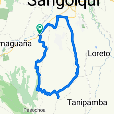
A cycling route starting in Sangolquí, Pichincha, Ecuador.
Overview
About this route
- 1 h 12 min
- Duration
- 11.8 km
- Distance
- 295 m
- Ascent
- 358 m
- Descent
- 9.9 km/h
- Avg. speed
- ---
- Max. altitude

Continue with Bikemap
Use, edit, or download this cycling route
You would like to ride De Troncal de la Sierra, Pifo a Troncal de la Sierra, Pifo or customize it for your own trip? Here is what you can do with this Bikemap route:
Free features
- Save this route as favorite or in collections
- Copy & plan your own version of this route
- Sync your route with Garmin or Wahoo
Premium features
Free trial for 3 days, or one-time payment. More about Bikemap Premium.
- Navigate this route on iOS & Android
- Export a GPX / KML file of this route
- Create your custom printout (try it for free)
- Download this route for offline navigation
Discover more Premium features.
Get Bikemap PremiumFrom our community
Other popular routes starting in Sangolquí
 Cotohurco
- Distance
- 30.4 km
- Ascent
- 1,084 m
- Descent
- 1,084 m
- Location
- Sangolquí, Pichincha, Ecuador
 cashapamba alto
- Distance
- 29.7 km
- Ascent
- 462 m
- Descent
- 437 m
- Location
- Sangolquí, Pichincha, Ecuador
 Club Los chillo-Pasochoa
- Distance
- 28.2 km
- Ascent
- 680 m
- Descent
- 681 m
- Location
- Sangolquí, Pichincha, Ecuador
 Descubriendo Conocoto II
- Distance
- 13.1 km
- Ascent
- 346 m
- Descent
- 351 m
- Location
- Sangolquí, Pichincha, Ecuador
 parque
- Distance
- 17.5 km
- Ascent
- 582 m
- Descent
- 550 m
- Location
- Sangolquí, Pichincha, Ecuador
 Amaguaña - Pasochoa 2011
- Distance
- 32.9 km
- Ascent
- 913 m
- Descent
- 913 m
- Location
- Sangolquí, Pichincha, Ecuador
 Vuelta al Pasochoa
- Distance
- 70.9 km
- Ascent
- 1,437 m
- Descent
- 1,422 m
- Location
- Sangolquí, Pichincha, Ecuador
 RUTA DE LOS VOLCANES
- Distance
- 37.8 km
- Ascent
- 1,781 m
- Descent
- 612 m
- Location
- Sangolquí, Pichincha, Ecuador
Open it in the app