
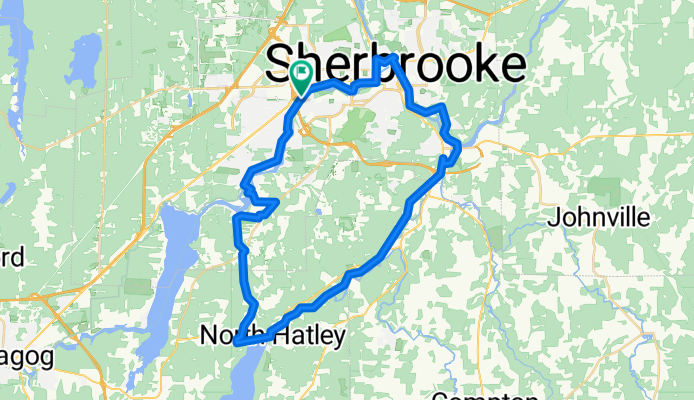
Sherbrooke - Grandes Fourches
A cycling route starting in Sherbrooke, Quebec, Canada.
Overview
About this route
- -:--
- Duration
- 52.5 km
- Distance
- 309 m
- Ascent
- 306 m
- Descent
- ---
- Avg. speed
- 315 m
- Avg. speed
Continue with Bikemap
Use, edit, or download this cycling route
You would like to ride Sherbrooke - Grandes Fourches or customize it for your own trip? Here is what you can do with this Bikemap route:
Free features
- Save this route as favorite or in collections
- Copy & plan your own version of this route
- Sync your route with Garmin or Wahoo
Premium features
Free trial for 3 days, or one-time payment. More about Bikemap Premium.
- Navigate this route on iOS & Android
- Export a GPX / KML file of this route
- Create your custom printout (try it for free)
- Download this route for offline navigation
Discover more Premium features.
Get Bikemap PremiumFrom our community
Other popular routes starting in Sherbrooke
 De Rue King Ouest 3950, Sherbrooke à Rue Comtois 4075, Sherbrooke
- Distance
- 9.8 km
- Ascent
- 153 m
- Descent
- 154 m
- Location
- Sherbrooke, Quebec, Canada
 Véloroute des Grandes Fourches
- Distance
- 65.5 km
- Ascent
- 543 m
- Descent
- 543 m
- Location
- Sherbrooke, Quebec, Canada
 Ch de Ste-Catherine, Sherbrooke à Place de la Gare, Sherbrooke
- Distance
- 19.1 km
- Ascent
- 119 m
- Descent
- 180 m
- Location
- Sherbrooke, Quebec, Canada
 Boucle : Sherbrooke, North Hatley, Lennoxville
- Distance
- 50.6 km
- Ascent
- 434 m
- Descent
- 431 m
- Location
- Sherbrooke, Quebec, Canada
 parc blanchard
- Distance
- 9.9 km
- Ascent
- 167 m
- Descent
- 168 m
- Location
- Sherbrooke, Quebec, Canada
 Promenade du jeudi
- Distance
- 19.3 km
- Ascent
- 82 m
- Descent
- 85 m
- Location
- Sherbrooke, Quebec, Canada
 35 km
35 km- Distance
- 29.2 km
- Ascent
- 270 m
- Descent
- 272 m
- Location
- Sherbrooke, Quebec, Canada
 Sherbrooke-Saint Denis-Saint-Élie-Sherb
- Distance
- 52.7 km
- Ascent
- 403 m
- Descent
- 402 m
- Location
- Sherbrooke, Quebec, Canada
Open it in the app