

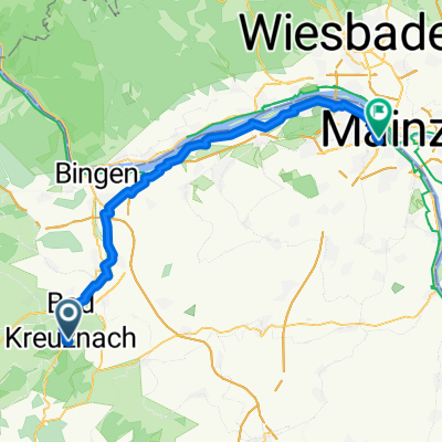
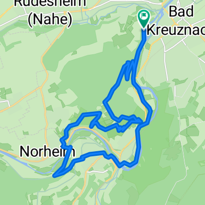
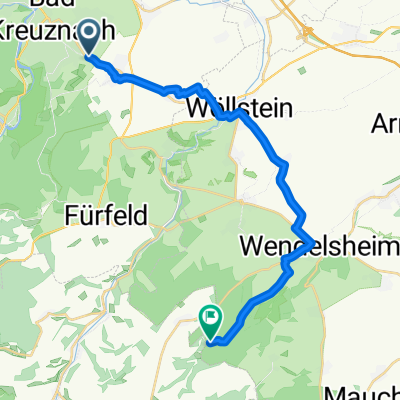
RLP13a: Bad Kreuznach - Monsheim 67,1km 394hm
A cycling route starting in Bad Kreuznach, Rhineland-Palatinate, Germany.
Overview
About this route
Bad Kreuznach - (APB Appelbach Cycle Path) - Planig Bosenheim - Pfaffen-Schwabenheim - Badenheim - Wöllstein - (Hiwwel Route) - Eckelsheim - Wonsheim - Stein-Bockenheim - Wendelsheim - Flohnheim - (from here, the route planner goes haywire, follow the Hiwwel Route signs!) - Alzey - Eppelsheim - Monsheim Hotel & Restaurant Zur Traube, Hauptstraße 92, 67590 Monsheim
- -:--
- Duration
- 67.1 km
- Distance
- 394 m
- Ascent
- 363 m
- Descent
- ---
- Avg. speed
- 243 m
- Max. altitude

Route quality
Waytypes & surfaces along the route
Waytypes
Track
30.9 km
(46 %)
Quiet road
12.7 km
(19 %)
Surfaces
Paved
53.7 km
(80 %)
Unpaved
3.4 km
(5 %)
Asphalt
31.5 km
(47 %)
Paved (undefined)
12.1 km
(18 %)
Route highlights
Points of interest along the route
Point of interest after 30.2 km
Routing Fehler! Links und dann rechts abbiegen
Continue with Bikemap
Use, edit, or download this cycling route
You would like to ride RLP13a: Bad Kreuznach - Monsheim 67,1km 394hm or customize it for your own trip? Here is what you can do with this Bikemap route:
Free features
- Save this route as favorite or in collections
- Copy & plan your own version of this route
- Sync your route with Garmin or Wahoo
Premium features
Free trial for 3 days, or one-time payment. More about Bikemap Premium.
- Navigate this route on iOS & Android
- Export a GPX / KML file of this route
- Create your custom printout (try it for free)
- Download this route for offline navigation
Discover more Premium features.
Get Bikemap PremiumFrom our community
Other popular routes starting in Bad Kreuznach
 Steubenstraße 18, Bad Kreuznach nach Carl-Schurz-Straße 25, Bad Kreuznach
- Distance
- 15.1 km
- Ascent
- 254 m
- Descent
- 253 m
- Location
- Bad Kreuznach, Rhineland-Palatinate, Germany
 Sporty route in Bad Kreuznach
- Distance
- 19.3 km
- Ascent
- 73 m
- Descent
- 76 m
- Location
- Bad Kreuznach, Rhineland-Palatinate, Germany
 Panoramatour Bad Kreuznach
- Distance
- 28.4 km
- Ascent
- 731 m
- Descent
- 730 m
- Location
- Bad Kreuznach, Rhineland-Palatinate, Germany
 Bad Sobernheim -Bad Kreuznach
- Distance
- 51.6 km
- Ascent
- 147 m
- Descent
- 242 m
- Location
- Bad Kreuznach, Rhineland-Palatinate, Germany
 Route in Bad Kreuznach
- Distance
- 18.4 km
- Ascent
- 869 m
- Descent
- 868 m
- Location
- Bad Kreuznach, Rhineland-Palatinate, Germany
 BK - WE - BK
- Distance
- 24 km
- Ascent
- 172 m
- Descent
- 169 m
- Location
- Bad Kreuznach, Rhineland-Palatinate, Germany
 From Bad Kreuznach to Wendelsheim
- Distance
- 19.6 km
- Ascent
- 313 m
- Descent
- 224 m
- Location
- Bad Kreuznach, Rhineland-Palatinate, Germany
 Weinkauffstraße nach Am Landgraben
- Distance
- 72.6 km
- Ascent
- 256 m
- Descent
- 327 m
- Location
- Bad Kreuznach, Rhineland-Palatinate, Germany
Open it in the app