

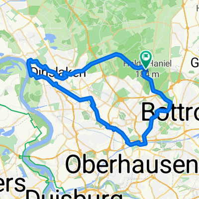
Am Schoolkamp 4, Bottrop nach Freiherr-vom-Stein-Straße 206C, Essen
A cycling route starting in Bottrop, North Rhine-Westphalia, Germany.
Overview
About this route
- 1 h 12 min
- Duration
- 20.8 km
- Distance
- 137 m
- Ascent
- 134 m
- Descent
- 17.2 km/h
- Avg. speed
- 131 m
- Avg. speed
Route quality
Waytypes & surfaces along the route
Waytypes
Busy road
11.2 km
(54 %)
Quiet road
5.7 km
(28 %)
Surfaces
Paved
20.3 km
(98 %)
Asphalt
17.7 km
(85 %)
Paving stones
2.5 km
(12 %)
Undefined
0.5 km
(2 %)
Continue with Bikemap
Use, edit, or download this cycling route
You would like to ride Am Schoolkamp 4, Bottrop nach Freiherr-vom-Stein-Straße 206C, Essen or customize it for your own trip? Here is what you can do with this Bikemap route:
Free features
- Save this route as favorite or in collections
- Copy & plan your own version of this route
- Sync your route with Garmin or Wahoo
Premium features
Free trial for 3 days, or one-time payment. More about Bikemap Premium.
- Navigate this route on iOS & Android
- Export a GPX / KML file of this route
- Create your custom printout (try it for free)
- Download this route for offline navigation
Discover more Premium features.
Get Bikemap PremiumFrom our community
Other popular routes starting in Bottrop
 11 Grafenmühle Schermbeck Krudenburg Grafenmühle
- Distance
- 48.4 km
- Ascent
- 129 m
- Descent
- 141 m
- Location
- Bottrop, North Rhine-Westphalia, Germany
 10 Grafenmühle - Bottr. Stadtpark
- Distance
- 14.5 km
- Ascent
- 84 m
- Descent
- 83 m
- Location
- Bottrop, North Rhine-Westphalia, Germany
 15 Jacobi Golfplatz - RHK - Landschaftspark Nord - HOAG
- Distance
- 32.9 km
- Ascent
- 54 m
- Descent
- 81 m
- Location
- Bottrop, North Rhine-Westphalia, Germany
 große Rotbach Rundtour
- Distance
- 50.3 km
- Ascent
- 140 m
- Descent
- 140 m
- Location
- Bottrop, North Rhine-Westphalia, Germany
 Radrunde durch Bottrop
- Distance
- 13.4 km
- Ascent
- 72 m
- Descent
- 70 m
- Location
- Bottrop, North Rhine-Westphalia, Germany
 Bottrop-Oberhausen-Duisburg-Bottrop
- Distance
- 55.7 km
- Ascent
- 112 m
- Descent
- 112 m
- Location
- Bottrop, North Rhine-Westphalia, Germany
 Osterfeld - Wesel (Grav-Insel) und zurück
- Distance
- 87.9 km
- Ascent
- 129 m
- Descent
- 141 m
- Location
- Bottrop, North Rhine-Westphalia, Germany
 RVR - Kirchheller Heide
- Distance
- 26.4 km
- Ascent
- 77 m
- Descent
- 87 m
- Location
- Bottrop, North Rhine-Westphalia, Germany
Open it in the app