

Chemnitzthalradweg-Taura-Burgstädt-Chemnitz
A cycling route starting in Chemnitz, Saxony, Germany.
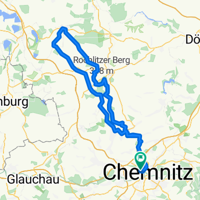
Overview
About this route
Wir starten ruhig und gemäßig den sehr gut ausgebauten Chemnitzthalradweg. Nach einem kurzem Stück auf der B107 biegen wir ein Richtung Taura. Immer Am Fluss entlang, kann man die wunderschöne Natur genießen. Ein kurzer Halt beim Museumsbahnhof Makerdorf kann eingelegt werden bevor es von Taura aus Richtung Burgstädt steil bergauf geht. In Burgstädt kann man einen kurzen Abstecher zum Minigolfen in den Wettinhain unternnehmen. Bei heißen Wetter ist ein Freibad Besuch ins nahegelegene Hartmannsdorf durchaus angebbracht. Über Taura gelangen wir wieder nach Makersdor. Von dort aus Fahren wir, den uns bereits bekannten Weg neben der Chemnitz zurück in die Innenstadt.
Tourprofil: eher Flach
Durchschnittgeschwindigkeit: 16-24 Km/H
Schwierigkeitsgrad: 2 für jeden Freizeitradler machbar.
- -:--
- Duration
- 42.2 km
- Distance
- 230 m
- Ascent
- 230 m
- Descent
- ---
- Avg. speed
- ---
- Avg. speed
Route quality
Waytypes & surfaces along the route
Waytypes
Busy road
20.7 km
(49 %)
Quiet road
7.4 km
(18 %)
Surfaces
Paved
37.1 km
(88 %)
Unpaved
0.5 km
(1 %)
Asphalt
35 km
(83 %)
Paving stones
1.8 km
(4 %)
Route highlights
Points of interest along the route
Point of interest after 15.2 km
Museumsbahnhof Makersdorf
Point of interest after 18.2 km
Wettinhain - Park + Minigol + Aussichtsturm + Freilichbühne
Point of interest after 21.4 km
Freibad - Eintritt 1-2 Euro
Continue with Bikemap
Use, edit, or download this cycling route
You would like to ride Chemnitzthalradweg-Taura-Burgstädt-Chemnitz or customize it for your own trip? Here is what you can do with this Bikemap route:
Free features
- Save this route as favorite or in collections
- Copy & plan your own version of this route
- Sync your route with Garmin or Wahoo
Premium features
Free trial for 3 days, or one-time payment. More about Bikemap Premium.
- Navigate this route on iOS & Android
- Export a GPX / KML file of this route
- Create your custom printout (try it for free)
- Download this route for offline navigation
Discover more Premium features.
Get Bikemap PremiumFrom our community
Other popular routes starting in Chemnitz
 Zschopextreme
- Distance
- 47.7 km
- Ascent
- 675 m
- Descent
- 677 m
- Location
- Chemnitz, Saxony, Germany
 Chemnitz - Rochlitzer Berg - Bad Lausick - Chemnitz 2
- Distance
- 108.4 km
- Ascent
- 546 m
- Descent
- 543 m
- Location
- Chemnitz, Saxony, Germany
 West- Nord- Runde (Grüna, Glöse, ...)
- Distance
- 49.8 km
- Ascent
- 339 m
- Descent
- 339 m
- Location
- Chemnitz, Saxony, Germany
 Abendrunde I
- Distance
- 30.6 km
- Ascent
- 218 m
- Descent
- 218 m
- Location
- Chemnitz, Saxony, Germany
 Zeisig-HELLYEAH-wald-1.0
- Distance
- 19.9 km
- Ascent
- 186 m
- Descent
- 186 m
- Location
- Chemnitz, Saxony, Germany
 4h Runde Chemnitz
- Distance
- 107.7 km
- Ascent
- 582 m
- Descent
- 572 m
- Location
- Chemnitz, Saxony, Germany
 Raben-Küch-Wald-Fetzt-Runde
- Distance
- 28.8 km
- Ascent
- 246 m
- Descent
- 254 m
- Location
- Chemnitz, Saxony, Germany
 Chemnitz Küchwald - Kriebstein und zurück
- Distance
- 71.5 km
- Ascent
- 567 m
- Descent
- 567 m
- Location
- Chemnitz, Saxony, Germany
Open it in the app