

044c: Ingelheim - Partenheim - Undenheim - Mommenheim - Nieder-Olm - Ingelheim
A cycling route starting in Ingelheim am Rhein, Rhineland-Palatinate, Germany.
Overview
About this route
Start- & Zielort: Tor 1
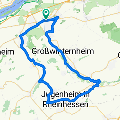
Ingelheim - Gau-Algesheim - Appenheim - Nieder-Hilbersheim - Engelstadt - Jugenheim - Partenheim - Saulheim - Udenheim - Schornsheim - Undenheim - Köngernheim - Selzen - Mommenheim - Zornheim - Nieder-Olm - Stadecken-Elsheim - Schwabenheim - Groß-Winternheim - Ingelheim
- -:--
- Duration
- 63.8 km
- Distance
- 507 m
- Ascent
- 506 m
- Descent
- ---
- Avg. speed
- ---
- Avg. speed
Route quality
Waytypes & surfaces along the route
Waytypes
Busy road
30.9 km
(48 %)
Road
10.2 km
(16 %)
Surfaces
Paved
57.5 km
(90 %)
Unpaved
2.6 km
(4 %)
Asphalt
49.9 km
(78 %)
Paving stones
4 km
(6 %)
Continue with Bikemap
Use, edit, or download this cycling route
You would like to ride 044c: Ingelheim - Partenheim - Undenheim - Mommenheim - Nieder-Olm - Ingelheim or customize it for your own trip? Here is what you can do with this Bikemap route:
Free features
- Save this route as favorite or in collections
- Copy & plan your own version of this route
- Sync your route with Garmin or Wahoo
Premium features
Free trial for 3 days, or one-time payment. More about Bikemap Premium.
- Navigate this route on iOS & Android
- Export a GPX / KML file of this route
- Create your custom printout (try it for free)
- Download this route for offline navigation
Discover more Premium features.
Get Bikemap PremiumFrom our community
Other popular routes starting in Ingelheim am Rhein
 2016 - 4. Tag
- Distance
- 102.8 km
- Ascent
- 271 m
- Descent
- 312 m
- Location
- Ingelheim am Rhein, Rhineland-Palatinate, Germany
 "Üwwer die Schiersteiner Brück!"
- Distance
- 39.5 km
- Ascent
- 55 m
- Descent
- 55 m
- Location
- Ingelheim am Rhein, Rhineland-Palatinate, Germany
 Kreuz ud Quer durch schöne Rhoihesse !
- Distance
- 152.1 km
- Ascent
- 1,064 m
- Descent
- 1,064 m
- Location
- Ingelheim am Rhein, Rhineland-Palatinate, Germany
 016d Ingelheim - Presberg - Bacharach - Rheinböllen - Stromberg - Ingelheim
- Distance
- 89.2 km
- Ascent
- 1,274 m
- Descent
- 1,258 m
- Location
- Ingelheim am Rhein, Rhineland-Palatinate, Germany
 Zur Rausch 5
- Distance
- 18 km
- Ascent
- 241 m
- Descent
- 176 m
- Location
- Ingelheim am Rhein, Rhineland-Palatinate, Germany
 32_Ingelheim – Jugenheim – Schwabenheim – Ingelheim
- Distance
- 35.6 km
- Ascent
- 262 m
- Descent
- 262 m
- Location
- Ingelheim am Rhein, Rhineland-Palatinate, Germany
 010c Ingelheim - Köngernheim - Undenheim - Ingelheim
- Distance
- 61 km
- Ascent
- 386 m
- Descent
- 325 m
- Location
- Ingelheim am Rhein, Rhineland-Palatinate, Germany
 Ingelh-Walgalgesh-Windesh-Ingelh 3
- Distance
- 53 km
- Ascent
- 328 m
- Descent
- 327 m
- Location
- Ingelheim am Rhein, Rhineland-Palatinate, Germany
Open it in the app