

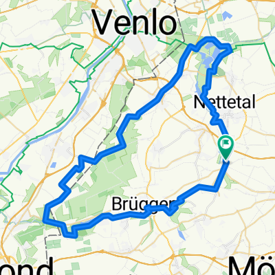
Lobberich-Kevelaer-Lobberich
A cycling route starting in Nettetal, North Rhine-Westphalia, Germany.
Overview
About this route
Landschaftlich tolle Tour, bei der man den Niederrhein so richtig erleben kann. Außerdem bieten Straelen, Walbeck und Keverlaer viele Möglichkeiten um sich zu stärken. Die Strecke ist eine ideale Trainingsstrecke für Rennräder und Handbiker, da sie ausschließlich asphaltiert ist.
- -:--
- Duration
- 74.6 km
- Distance
- 98 m
- Ascent
- 110 m
- Descent
- ---
- Avg. speed
- 73 m
- Avg. speed
Route quality
Waytypes & surfaces along the route
Waytypes
Quiet road
25.8 km
(35 %)
Path
19 km
(25 %)
Surfaces
Paved
59.2 km
(79 %)
Unpaved
2.7 km
(4 %)
Asphalt
53.1 km
(71 %)
Paving stones
4.3 km
(6 %)
Continue with Bikemap
Use, edit, or download this cycling route
You would like to ride Lobberich-Kevelaer-Lobberich or customize it for your own trip? Here is what you can do with this Bikemap route:
Free features
- Save this route as favorite or in collections
- Copy & plan your own version of this route
- Sync your route with Garmin or Wahoo
Premium features
Free trial for 3 days, or one-time payment. More about Bikemap Premium.
- Navigate this route on iOS & Android
- Export a GPX / KML file of this route
- Create your custom printout (try it for free)
- Download this route for offline navigation
Discover more Premium features.
Get Bikemap PremiumFrom our community
Other popular routes starting in Nettetal
 Nettetalrunde
- Distance
- 30.8 km
- Ascent
- 101 m
- Descent
- 104 m
- Location
- Nettetal, North Rhine-Westphalia, Germany
 Unbenannte Route
- Distance
- 362.8 km
- Ascent
- 553 m
- Descent
- 556 m
- Location
- Nettetal, North Rhine-Westphalia, Germany
 Schwalm-Nette
- Distance
- 46.3 km
- Ascent
- 57 m
- Descent
- 58 m
- Location
- Nettetal, North Rhine-Westphalia, Germany
 Heinz Route 1
- Distance
- 18.4 km
- Ascent
- 61 m
- Descent
- 61 m
- Location
- Nettetal, North Rhine-Westphalia, Germany
 Heide-Seen Tour (Nettetal)
- Distance
- 59.3 km
- Ascent
- 106 m
- Descent
- 106 m
- Location
- Nettetal, North Rhine-Westphalia, Germany
 GL`s Seen-MTB-Strecke
- Distance
- 33.1 km
- Ascent
- 124 m
- Descent
- 124 m
- Location
- Nettetal, North Rhine-Westphalia, Germany
 „N“, die Nettetal-Runde, gegen Uhrzeiger
- Distance
- 30.2 km
- Ascent
- 111 m
- Descent
- 111 m
- Location
- Nettetal, North Rhine-Westphalia, Germany
 Lobberich,Herongen,VenloerHeide,Krickenbeck,Lobberich
- Distance
- 26 km
- Ascent
- 55 m
- Descent
- 56 m
- Location
- Nettetal, North Rhine-Westphalia, Germany
Open it in the app