
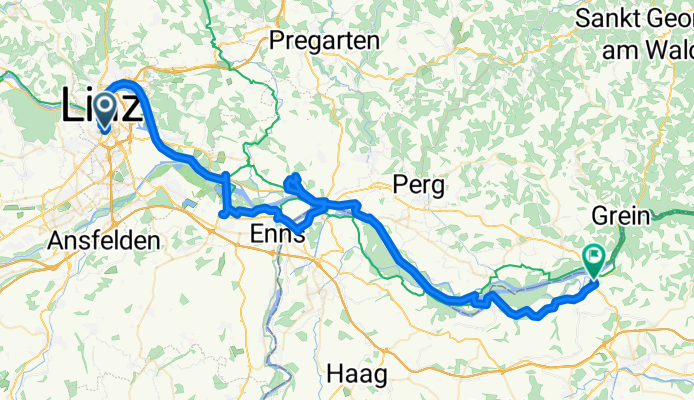
Da Böhmerwaldstraße 13, Linz a Marktplatz 53–55, Ardagger
A cycling route starting in Linz, Upper Austria, Austria.
Overview
About this route
- 4 h 23 min
- Duration
- 76.6 km
- Distance
- 758 m
- Ascent
- 786 m
- Descent
- 17.5 km/h
- Avg. speed
- ---
- Avg. speed
Route quality
Waytypes & surfaces along the route
Waytypes
Cycleway
25.5 km
(33 %)
Quiet road
20.5 km
(27 %)
Surfaces
Paved
61 km
(80 %)
Unpaved
0.5 km
(<1 %)
Asphalt
59.5 km
(78 %)
Paving stones
1.1 km
(1 %)
Continue with Bikemap
Use, edit, or download this cycling route
You would like to ride Da Böhmerwaldstraße 13, Linz a Marktplatz 53–55, Ardagger or customize it for your own trip? Here is what you can do with this Bikemap route:
Free features
- Save this route as favorite or in collections
- Copy & plan your own version of this route
- Sync your route with Garmin or Wahoo
Premium features
Free trial for 3 days, or one-time payment. More about Bikemap Premium.
- Navigate this route on iOS & Android
- Export a GPX / KML file of this route
- Create your custom printout (try it for free)
- Download this route for offline navigation
Discover more Premium features.
Get Bikemap PremiumFrom our community
Other popular routes starting in Linz
 St. Martin- Lichtenhah-Lichtenberg
- Distance
- 73.2 km
- Ascent
- 1,240 m
- Descent
- 1,241 m
- Location
- Linz, Upper Austria, Austria
 Pferdeeisenbahn-Innertreffling-Forst-Pulgarn-Steyregg-Pfenningberg-Plesching
- Distance
- 42.8 km
- Ascent
- 674 m
- Descent
- 677 m
- Location
- Linz, Upper Austria, Austria
 plesching
- Distance
- 32.6 km
- Ascent
- 325 m
- Descent
- 326 m
- Location
- Linz, Upper Austria, Austria
 Süden von Linz
- Distance
- 42.4 km
- Ascent
- 186 m
- Descent
- 187 m
- Location
- Linz, Upper Austria, Austria
 Steyregg Runde
- Distance
- 22 km
- Ascent
- 218 m
- Descent
- 220 m
- Location
- Linz, Upper Austria, Austria
 Giselawarte - GIS
- Distance
- 27.7 km
- Ascent
- 914 m
- Descent
- 834 m
- Location
- Linz, Upper Austria, Austria
 Oberbairing-Altenberg-Galli-Linz
- Distance
- 27.8 km
- Ascent
- 496 m
- Descent
- 496 m
- Location
- Linz, Upper Austria, Austria
 Pfenningberg Tour
- Distance
- 28.9 km
- Ascent
- 458 m
- Descent
- 458 m
- Location
- Linz, Upper Austria, Austria
Open it in the app