

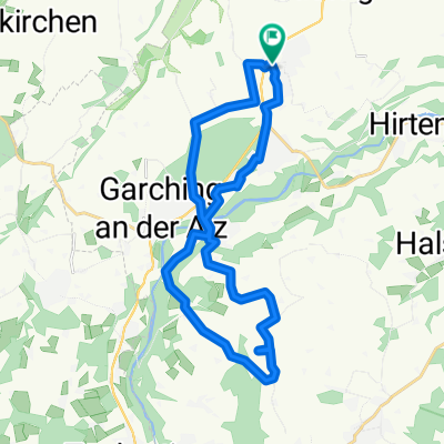
Bräu im Moos Straße 1, Tüßling nach Hauptstraße 26, Töging am Inn
A cycling route starting in Unterneukirchen, Bavaria, Germany.
Overview
About this route
- 1 h 41 min
- Duration
- 19.9 km
- Distance
- 22 m
- Ascent
- 28 m
- Descent
- 11.8 km/h
- Avg. speed
- ---
- Avg. speed

Route quality
Waytypes & surfaces along the route
Waytypes
Quiet road
10.1 km
(51 %)
Track
6 km
(30 %)
Surfaces
Paved
12.9 km
(65 %)
Unpaved
6.1 km
(31 %)
Asphalt
12.9 km
(65 %)
Loose gravel
2.7 km
(13 %)
Continue with Bikemap
Use, edit, or download this cycling route
You would like to ride Bräu im Moos Straße 1, Tüßling nach Hauptstraße 26, Töging am Inn or customize it for your own trip? Here is what you can do with this Bikemap route:
Free features
- Save this route as favorite or in collections
- Copy & plan your own version of this route
- Sync your route with Garmin or Wahoo
Premium features
Free trial for 3 days, or one-time payment. More about Bikemap Premium.
- Navigate this route on iOS & Android
- Export a GPX / KML file of this route
- Create your custom printout (try it for free)
- Download this route for offline navigation
Discover more Premium features.
Get Bikemap PremiumFrom our community
Other popular routes starting in Unterneukirchen
 Planetenweg
- Distance
- 23.6 km
- Ascent
- 185 m
- Descent
- 185 m
- Location
- Unterneukirchen, Bavaria, Germany
 Untergünzl 1, Unterneukirchen nach Finkenzellerstraße 1, Garching an der Alz
- Distance
- 12.6 km
- Ascent
- 152 m
- Descent
- 205 m
- Location
- Unterneukirchen, Bavaria, Germany
 gasteig-mühlhof-unternk.-eck
- Distance
- 25.3 km
- Ascent
- 96 m
- Descent
- 118 m
- Location
- Unterneukirchen, Bavaria, Germany
 wald-kirchweidach-hart alz
- Distance
- 35.8 km
- Ascent
- 275 m
- Descent
- 280 m
- Location
- Unterneukirchen, Bavaria, Germany
 Mauerberger Straße 15, Unterneukirchen nach Mauerberger Straße 15, Unterneukirchen
- Distance
- 24.2 km
- Ascent
- 204 m
- Descent
- 205 m
- Location
- Unterneukirchen, Bavaria, Germany
 Unterneukirchen - Alz- Rundfahrt
- Distance
- 19.1 km
- Ascent
- 86 m
- Descent
- 89 m
- Location
- Unterneukirchen, Bavaria, Germany
 Burghausen
- Distance
- 27.9 km
- Ascent
- 205 m
- Descent
- 290 m
- Location
- Unterneukirchen, Bavaria, Germany
 eck wald kirchweidach hart eck
- Distance
- 32.8 km
- Ascent
- 281 m
- Descent
- 286 m
- Location
- Unterneukirchen, Bavaria, Germany
Open it in the app