

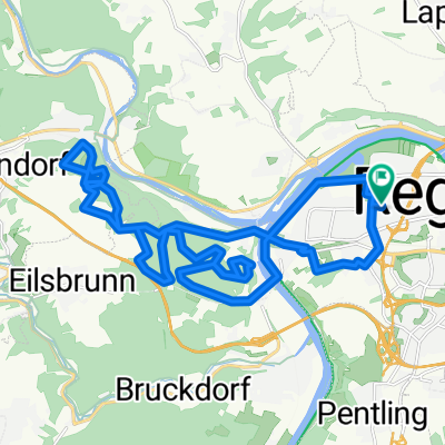
Regensburg - Marienhöhe - Nittendorf - Waldetzenberg
A cycling route starting in Sinzing, Bavaria, Germany.
Overview
About this route
Fahrt nach Waldetzenberg
- -:--
- Duration
- 13.6 km
- Distance
- 365 m
- Ascent
- 227 m
- Descent
- ---
- Avg. speed
- ---
- Avg. speed

Continue with Bikemap
Use, edit, or download this cycling route
You would like to ride Regensburg - Marienhöhe - Nittendorf - Waldetzenberg or customize it for your own trip? Here is what you can do with this Bikemap route:
Free features
- Save this route as favorite or in collections
- Copy & plan your own version of this route
- Sync your route with Garmin or Wahoo
Premium features
Free trial for 3 days, or one-time payment. More about Bikemap Premium.
- Navigate this route on iOS & Android
- Export a GPX / KML file of this route
- Create your custom printout (try it for free)
- Download this route for offline navigation
Discover more Premium features.
Get Bikemap PremiumFrom our community
Other popular routes starting in Sinzing
 Regensburg
- Distance
- 17.1 km
- Ascent
- 168 m
- Descent
- 169 m
- Location
- Sinzing, Bavaria, Germany
 Pettendorf/Wallfahrtskirche Maria Ort - Kallmünz vv
- Distance
- 52.5 km
- Ascent
- 1,299 m
- Descent
- 1,303 m
- Location
- Sinzing, Bavaria, Germany
 Pettendorf - Kallmünz
- Distance
- 28.5 km
- Ascent
- 991 m
- Descent
- 983 m
- Location
- Sinzing, Bavaria, Germany
 Alling, Hohe Wand
- Distance
- 17.2 km
- Ascent
- 346 m
- Descent
- 352 m
- Location
- Sinzing, Bavaria, Germany
 Bernhardswalder Runde
- Distance
- 12.4 km
- Ascent
- 258 m
- Descent
- 259 m
- Location
- Sinzing, Bavaria, Germany
 Regensburg - Kallmuenz
- Distance
- 55.5 km
- Ascent
- 722 m
- Descent
- 815 m
- Location
- Sinzing, Bavaria, Germany
 Rundfahrt Regensburg-Riedenburg
- Distance
- 77.6 km
- Ascent
- 782 m
- Descent
- 777 m
- Location
- Sinzing, Bavaria, Germany
 Ultimate Trail Regensburg
- Distance
- 27.7 km
- Ascent
- 550 m
- Descent
- 550 m
- Location
- Sinzing, Bavaria, Germany
Open it in the app