
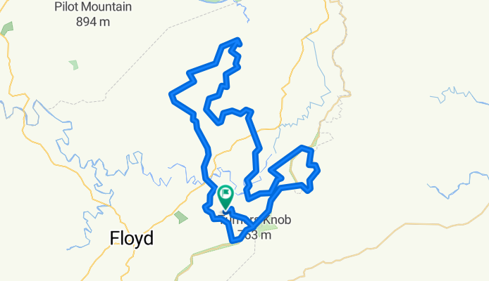
Showing Dan the gravelachia goods 🚴♂️☀️👍
A cycling route starting in Floyd, Virginia, United States of America.
Overview
About this route
- -:--
- Duration
- 86.6 km
- Distance
- 1,879 m
- Ascent
- 1,879 m
- Descent
- ---
- Avg. speed
- 854 m
- Avg. speed

Route quality
Waytypes & surfaces along the route
Waytypes
Quiet road
63.3 km
(73 %)
Road
17.1 km
(20 %)
Surfaces
Paved
1.1 km
(1 %)
Unpaved
64 km
(74 %)
Gravel
37.7 km
(43 %)
Unpaved (undefined)
26.3 km
(30 %)
Continue with Bikemap
Use, edit, or download this cycling route
You would like to ride Showing Dan the gravelachia goods 🚴♂️☀️👍 or customize it for your own trip? Here is what you can do with this Bikemap route:
Free features
- Save this route as favorite or in collections
- Copy & plan your own version of this route
- Sync your route with Garmin or Wahoo
Premium features
Free trial for 3 days, or one-time payment. More about Bikemap Premium.
- Navigate this route on iOS & Android
- Export a GPX / KML file of this route
- Create your custom printout (try it for free)
- Download this route for offline navigation
Discover more Premium features.
Get Bikemap PremiumFrom our community
Other popular routes starting in Floyd
 Showing Dan the gravelachia goods 🚴♂️☀️👍
- Distance
- 86.6 km
- Ascent
- 1,879 m
- Descent
- 1,879 m
- Location
- Floyd, Virginia, United States of America
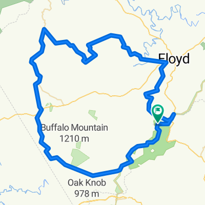 West Floyd (Sat)
- Distance
- 90.8 km
- Ascent
- 1,095 m
- Descent
- 1,095 m
- Location
- Floyd, Virginia, United States of America
 West Floyd Sat. Ride CLONED FROM ROUTE 633816
- Distance
- 99.6 km
- Ascent
- 1,205 m
- Descent
- 1,194 m
- Location
- Floyd, Virginia, United States of America
 Blue Ridge Shooting Creek Loop
- Distance
- 61.8 km
- Ascent
- 1,065 m
- Descent
- 1,051 m
- Location
- Floyd, Virginia, United States of America
 09-Rknob-RoanokeQInn-detour-48-2953
- Distance
- 77.1 km
- Ascent
- 1,153 m
- Descent
- 1,739 m
- Location
- Floyd, Virginia, United States of America
 Blue Ridge Parkway, Floyd to Blue Ridge Parkway, Floyd
- Distance
- 16.7 km
- Ascent
- 954 m
- Descent
- 954 m
- Location
- Floyd, Virginia, United States of America
 Day 4: Rocky Knob to Doughton Park
- Distance
- 124.2 km
- Ascent
- 1,158 m
- Descent
- 990 m
- Location
- Floyd, Virginia, United States of America
 blue ridge a/r Smart
- Distance
- 50.1 km
- Ascent
- 541 m
- Descent
- 541 m
- Location
- Floyd, Virginia, United States of America
Open it in the app