
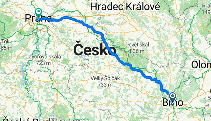
Brno - Prag
A cycling route starting in Brno, South Moravian, Czechia.
Overview
About this route
- -:--
- Duration
- 240.6 km
- Distance
- 917 m
- Ascent
- 940 m
- Descent
- ---
- Avg. speed
- 673 m
- Avg. speed

Route quality
Waytypes & surfaces along the route
Waytypes
Road
122.6 km
(51 %)
Quiet road
53.5 km
(22 %)
Surfaces
Paved
104.4 km
(43 %)
Unpaved
3.9 km
(2 %)
Asphalt
95.8 km
(40 %)
Paved (undefined)
5.8 km
(2 %)
Continue with Bikemap
Use, edit, or download this cycling route
You would like to ride Brno - Prag or customize it for your own trip? Here is what you can do with this Bikemap route:
Free features
- Save this route as favorite or in collections
- Copy & plan your own version of this route
- Sync your route with Garmin or Wahoo
Premium features
Free trial for 3 days, or one-time payment. More about Bikemap Premium.
- Navigate this route on iOS & Android
- Export a GPX / KML file of this route
- Create your custom printout (try it for free)
- Download this route for offline navigation
Discover more Premium features.
Get Bikemap PremiumFrom our community
Other popular routes starting in Brno
 Brno-North #1
- Distance
- 46.2 km
- Ascent
- 506 m
- Descent
- 506 m
- Location
- Brno, South Moravian, Czechia
 Brno-Přehrada-Veveří-Brno
- Distance
- 30.2 km
- Ascent
- 339 m
- Descent
- 341 m
- Location
- Brno, South Moravian, Czechia
 Brno, Anenská - Antropos - Pisárky - Mendlovo náměstí - a zpět (běh)
- Distance
- 8 km
- Ascent
- 101 m
- Descent
- 103 m
- Location
- Brno, South Moravian, Czechia
 Kr.Pole-Soběšice - Mokrá Hora - Kr.Pole
- Distance
- 15.7 km
- Ascent
- 214 m
- Descent
- 214 m
- Location
- Brno, South Moravian, Czechia
 Na Alexandrovu rozhlednu
- Distance
- 52.6 km
- Ascent
- 813 m
- Descent
- 815 m
- Location
- Brno, South Moravian, Czechia
 Brno - Dukovany - Mor. Krumlov - Brno
- Distance
- 114.7 km
- Ascent
- 986 m
- Descent
- 986 m
- Location
- Brno, South Moravian, Czechia
 Brno-Lelekovice-Kuřim-Veveří-Brno
- Distance
- 45.7 km
- Ascent
- 424 m
- Descent
- 424 m
- Location
- Brno, South Moravian, Czechia
 Zimní Mariánské údolí a Mokerská hájovna
- Distance
- 31.3 km
- Ascent
- 353 m
- Descent
- 353 m
- Location
- Brno, South Moravian, Czechia
Open it in the app