

Donauinsel Wehr bis Greifenstein Trinkwasserstelle
A cycling route starting in Langenzersdorf, Lower Austria, Austria.
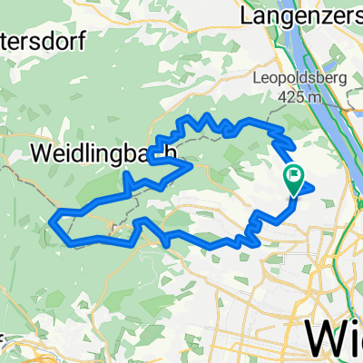
Overview
About this route
Vom Wehr am Beginn der Donauinsel über den Treppelweg entlang des linken Donauufers bis zur Trinkwasserstelle beim Kraftwerk Greifenstein.
- -:--
- Duration
- 12.5 km
- Distance
- 97 m
- Ascent
- 86 m
- Descent
- ---
- Avg. speed
- ---
- Avg. speed

Route quality
Waytypes & surfaces along the route
Waytypes
Cycleway
9.9 km
(79 %)
Quiet road
1.7 km
(14 %)
Surfaces
Paved
12.5 km
(100 %)
Unpaved
0 km
(<1 %)
Asphalt
12.4 km
(99 %)
Wood
0.1 km
(<1 %)
Gravel
0 km
(<1 %)
Continue with Bikemap
Use, edit, or download this cycling route
You would like to ride Donauinsel Wehr bis Greifenstein Trinkwasserstelle or customize it for your own trip? Here is what you can do with this Bikemap route:
Free features
- Save this route as favorite or in collections
- Copy & plan your own version of this route
- Sync your route with Garmin or Wahoo
Premium features
Free trial for 3 days, or one-time payment. More about Bikemap Premium.
- Navigate this route on iOS & Android
- Export a GPX / KML file of this route
- Create your custom printout (try it for free)
- Download this route for offline navigation
Discover more Premium features.
Get Bikemap PremiumFrom our community
Other popular routes starting in Langenzersdorf
 Langenzersdorf Cycling
- Distance
- 15.6 km
- Ascent
- 546 m
- Descent
- 237 m
- Location
- Langenzersdorf, Lower Austria, Austria
 Kahlenbergdorf- + Babenbergerstrecke(?) CLONED FROM ROUTE 455394
- Distance
- 40.8 km
- Ascent
- 703 m
- Descent
- 700 m
- Location
- Langenzersdorf, Lower Austria, Austria
 khalen
- Distance
- 6 km
- Ascent
- 85 m
- Descent
- 358 m
- Location
- Langenzersdorf, Lower Austria, Austria
 Höhenstraßen - Marathon (Wien) CLONED FROM ROUTE 53730
- Distance
- 95.6 km
- Ascent
- 1,485 m
- Descent
- 1,493 m
- Location
- Langenzersdorf, Lower Austria, Austria
 Wienerwald 2
- Distance
- 35.6 km
- Ascent
- 775 m
- Descent
- 774 m
- Location
- Langenzersdorf, Lower Austria, Austria
 Weinradroute - Donau-Veltliner
- Distance
- 58.1 km
- Ascent
- 368 m
- Descent
- 367 m
- Location
- Langenzersdorf, Lower Austria, Austria
 Wien (Donauinsel) - Buschberg - Wien
- Distance
- 130.6 km
- Ascent
- 1,430 m
- Descent
- 1,420 m
- Location
- Langenzersdorf, Lower Austria, Austria
 Kloburgrunde, ca.700 hm
- Distance
- 53.9 km
- Ascent
- 705 m
- Descent
- 705 m
- Location
- Langenzersdorf, Lower Austria, Austria
Open it in the app