Summer on a bike
A cycling route starting in Saint-Martin-le-Vinoux, Auvergne-Rhône-Alpes, France.
Overview
About this route
Départ : Grenoble 14 juillet 14h – Arrivée : Grenoble 29 août 19h
30 jours de vélo : dont 18 premiers jours aller en continu puis combiné avec visites famille/amis sur le retour
Trajet total : 3600km ; 42000m+ ; 207h
Moyenne /jour : 120km; 1400m+; 7h
Poids: Vélo 12 kg | Sacoches 12kg sans nourriture | Cycliste 70kg avant 65kg après
Pays traversés : 6
Personnes rencontrées : X Belles Rencontres surtout sur les 18 premiers jours nomades ; 1 Mauvaise
Animaux croisés : Beaucoup ; surtout morts (route)
Nuits : 100% Bivouac sauf 1 chez l’habitant + 1 warmshower
Douches : Peu
Accès eau et électricité : Régulier
Lieu à + explorer : Dolomites <3
FRANCE
DAY 1: Grenoble - Bourg d’Oisans - Villar d'Arêne (proche du col du Lautaret) | 87km
DAY 2: Col du Lautaret (2000m) - Briançon - col de Montgenèvre (1800m) - Lago di Avigliana (prox. Turin) | 127km
ITALIA
DAY 3: Turin - Vallée Piémont avec pluie - Santhià | 105km
DAY 4: Santhià - Grignasco - Sesto Calende - Varèse | 118km
DAY 5: Varèse - Como - Brivio - Bergamo - Calepio Castle | 116km
DAY 6: Lago d'Iseo - Lovere - Edolo - Ponte de Legno (Poia <3) | 111km 1,2km+
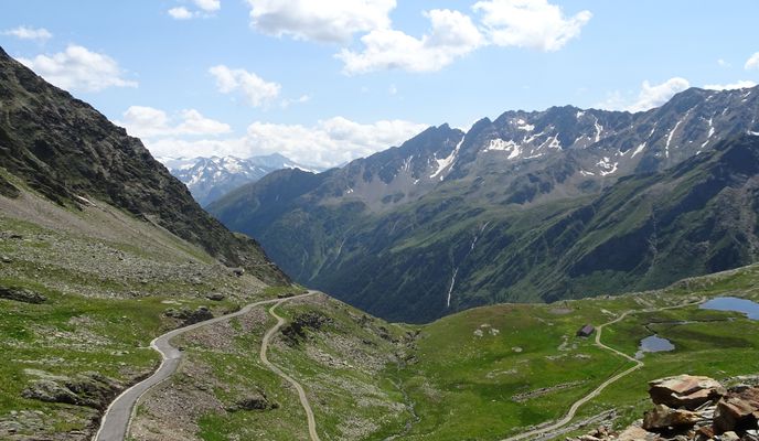
DAY 7: Ponte di Legno - Passo di Gavia (2600m) sur les rotules - Bormio - Passo di Fraile (1900m) - Lago Di Cascano | 70km 2.1km+
DAY 8: Val Mora - 30 km gravel pour rejoindre la Suisse - Prato allo Stelvio - Passo dello Stelvio (2700m) | 100km 2.2km+
DAY 9: Prato allo Stelvio - Merano - Bolzano - début vallée pour les Dolomites | 115km
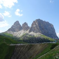
DAY 10 Dolomiti: Sankt Ulrich - Passo di Sella (2200m) - Passo di Gardena (2100m) - Passo Valparola (2200m) - Cortina d'Ampezzo | 97km 2.7km+
DAY 11: Cortina d'Ampezzo - Passo Tre Croci (1800m) - Lienz (AUT) - Iselsberg (1200m) - Mörtschach début montée Grossglocknerstr. | 113km 1.4km+
ÖSTERREICH
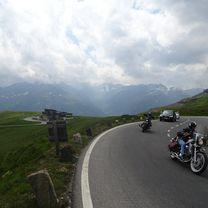
DAY 12 Grossglockner: Heiligenblut - Hochtor (2500m) en Zigzag - Zell am See - Train to Salzburg (Réparation vélo) | 81km 1.9km+
DAY 13: Salzburg - Braunau am Inn - Ering | 96km
DEUTSCHLAND
DAY 14: Ering - Passau - Bayerischer Wald - Philippsreut | 119km 1.8km+
CESKA REPUBLIKA
DAY 15 Böhmer Wald : Philippsreut - Kvilda - Nyrsko - Vseruby | 127km 1.5km+
DAY 16: Vseruby - Babylon - Rybnik - Tachov - Drmoul | 107km 1.7km+
DAY 17: Marianske Lazne - Karovy Vary - Erzgebirge (Fichtelberg) - Crahnzahl | 111km 1.5km+
DEUTSCHLAND
DAY 18: Annaberg-Buchholz - Chemnitz - Leipzig | 135km 1km+
VISITS FOR 9 DAYS
DAY 19: Leipzig - Halle - Lutherstadt Eisleben - Südharz (Wippra) | 112km
DAY 20 Harz: Wippra - Harzgerode - Königskrug (800m) - Sonnenberg (900m) - Osterode - Wulften | 117km 1.3km+
DAY 21: Wulften - Göttingen - Witzenhausen - Goldbergsee | 113km 1.1km+
DAY 22: Homberg - Treysa - Marburg - Giessen - Friedberg - Sbahn to Frankfurt (Main) | 160km 7h50 1km+ (longest ride)
VISIT FOR 1 DAY
DAY 23 Rhin romantique EV15: Frankfurt - Mainz - Bingen am Rhein - Loreley - Brey (Koblenz) | 131 km
DAY 24: Koblenz - Ahrweiler | 85km
VISITS FOR 3 DAYS
Train to Mannheim
Half DAY 25: Mannheim - Speyer (Reparatur) - Wörth am Rhein - Muggensturm (Schwarzwald) | 86km
DAY 26 Schwarzwald: S Bahn to Freudenstadt - Schramberg - St. Georgen - Furtwangen - Heuweiler (Freiburg) | 126km 1.5km+
Half DAY 27: Freiburg - Fessenheim - Mulhouse | 70km
VISITS FOR 1.5 DAYS
SUISSE
DAY 28: Mulhouse - Sundgau - Parc régional du Doubs - La Chaux de Fonds | 128km 1.8km+
DAY 29: La Chaux de Fonds - Sibérie de la Suisse - Route de l'Absinthe - Jura FR - Vallorbe - Vallée de la Joux - Moussières | 130km 1.7km+
FRANCE
DAY 30: Moussières - Le Poizat - Ain - col de Bérentin (1100m) - Culoz - Via Rhôna (lol) - Aix-les-Bains | 111 km 1.2km+
VISIT FOR 2 DAYS
DAY 31: Aix-les-Bains - Chambéry - Traversée de la Chartreuse (Col du Granier, Col du Cucheron, Col de Porte 1100-1300m) - Grenoble | 80km 2.1km+
- -:--
- Duration
- 3,601.6 km
- Distance
- 9,880 m
- Ascent
- 9,877 m
- Descent
- ---
- Avg. speed
- 2,145 m
- Avg. speed
Route photos
Route highlights
Points of interest along the route

Point of interest after 981.9 km
Thanks for your curiosity!
Continue with Bikemap
Use, edit, or download this cycling route
You would like to ride Summer on a bike or customize it for your own trip? Here is what you can do with this Bikemap route:
Free features
- Save this route as favorite or in collections
- Copy & plan your own version of this route
- Sync your route with Garmin or Wahoo
Premium features
Free trial for 3 days, or one-time payment. More about Bikemap Premium.
- Navigate this route on iOS & Android
- Export a GPX / KML file of this route
- Create your custom printout (try it for free)
- Download this route for offline navigation
Discover more Premium features.
Get Bikemap PremiumFrom our community
Other popular routes starting in Saint-Martin-le-Vinoux
 12 March 23, bike stroll (Saint Laurent)
- Distance
- 6.6 km
- Ascent
- 28 m
- Descent
- 23 m
- Location
- Saint-Martin-le-Vinoux, Auvergne-Rhône-Alpes, France
 ancien tram-vouillants
- Distance
- 18.4 km
- Ascent
- 587 m
- Descent
- 585 m
- Location
- Saint-Martin-le-Vinoux, Auvergne-Rhône-Alpes, France
 Grenoble-Bernin-Brigaud-Grenoble
- Distance
- 39.5 km
- Ascent
- 250 m
- Descent
- 250 m
- Location
- Saint-Martin-le-Vinoux, Auvergne-Rhône-Alpes, France
 Sortie boulot version courte
- Distance
- 19.8 km
- Ascent
- 499 m
- Descent
- 498 m
- Location
- Saint-Martin-le-Vinoux, Auvergne-Rhône-Alpes, France
 Test 1 Bastille
- Distance
- 14.1 km
- Ascent
- 542 m
- Descent
- 542 m
- Location
- Saint-Martin-le-Vinoux, Auvergne-Rhône-Alpes, France
 Tour de France - Etappe 20
- Distance
- 42.8 km
- Ascent
- 424 m
- Descent
- 417 m
- Location
- Saint-Martin-le-Vinoux, Auvergne-Rhône-Alpes, France
 Montée au Charmant Som via Clémencière
- Distance
- 22.7 km
- Ascent
- 1,539 m
- Descent
- 82 m
- Location
- Saint-Martin-le-Vinoux, Auvergne-Rhône-Alpes, France
 2016 Ride Day 151 - Grenoble to Pont-en-Royans
- Distance
- 69.7 km
- Ascent
- 1,037 m
- Descent
- 1,056 m
- Location
- Saint-Martin-le-Vinoux, Auvergne-Rhône-Alpes, France
Open it in the app


