

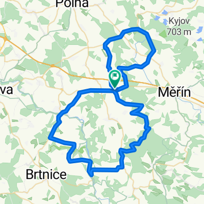
REHOROV-VELKE MEZIRIC-TASOV-RUDIKOV-REHOROV
A cycling route starting in Kamenice, Kraj Vysočina, Czechia.
Overview
About this route
DNES JSME IS DLA TRESU PODEL BALINKY AZ DO TASOVA A POTOM CYKLOSTESKOU AZ DO RUDIKOVA A POKRACOVAL JSEM PO STEZCE AZ DO MERINA JETO PARADNI PROJIZDA VUBEC JSE NEJEDE PO VEREJNY KOMUNIKACI DOPORUCUJU
- -:--
- Duration
- 73.4 km
- Distance
- 502 m
- Ascent
- 502 m
- Descent
- ---
- Avg. speed
- ---
- Avg. speed
Route quality
Waytypes & surfaces along the route
Waytypes
Track
29.5 km
(40 %)
Road
14.2 km
(19 %)
Surfaces
Paved
3.7 km
(5 %)
Unpaved
27.5 km
(37 %)
Unpaved (undefined)
16 km
(22 %)
Gravel
9.5 km
(13 %)
Continue with Bikemap
Use, edit, or download this cycling route
You would like to ride REHOROV-VELKE MEZIRIC-TASOV-RUDIKOV-REHOROV or customize it for your own trip? Here is what you can do with this Bikemap route:
Free features
- Save this route as favorite or in collections
- Copy & plan your own version of this route
- Sync your route with Garmin or Wahoo
Premium features
Free trial for 3 days, or one-time payment. More about Bikemap Premium.
- Navigate this route on iOS & Android
- Export a GPX / KML file of this route
- Create your custom printout (try it for free)
- Download this route for offline navigation
Discover more Premium features.
Get Bikemap PremiumFrom our community
Other popular routes starting in Kamenice
 REHOROV-VELKE MEZIRIC-TASOV-RUDIKOV-REHOROV
- Distance
- 73.4 km
- Ascent
- 502 m
- Descent
- 502 m
- Location
- Kamenice, Kraj Vysočina, Czechia
 rehorov-mostiste-baliny-rehorov
- Distance
- 62.6 km
- Ascent
- 601 m
- Descent
- 563 m
- Location
- Kamenice, Kraj Vysočina, Czechia
 rehorov-namest nad oslavou -naramec-velke mezirici-rehorov
- Distance
- 110.5 km
- Ascent
- 545 m
- Descent
- 545 m
- Location
- Kamenice, Kraj Vysočina, Czechia
 rehorov-jihlava-polna-rehorov
- Distance
- 48 km
- Ascent
- 512 m
- Descent
- 512 m
- Location
- Kamenice, Kraj Vysočina, Czechia
 rehorov-luka nad jihlavou-kouty-staj-rehorov
- Distance
- 65.8 km
- Ascent
- 733 m
- Descent
- 733 m
- Location
- Kamenice, Kraj Vysočina, Czechia
 rehorov -horni radslavice-staj-rehorov
- Distance
- 55.9 km
- Ascent
- 541 m
- Descent
- 541 m
- Location
- Kamenice, Kraj Vysočina, Czechia
 turisticke znamky
- Distance
- 105.3 km
- Ascent
- 728 m
- Descent
- 733 m
- Location
- Kamenice, Kraj Vysočina, Czechia
 rehorov-mostiste-merin-pavlinov-mostiste-dedkova hora-rehorov
- Distance
- 96.3 km
- Ascent
- 807 m
- Descent
- 807 m
- Location
- Kamenice, Kraj Vysočina, Czechia
Open it in the app