

Szosowa 60-tka - propozycja trasy od GreeneBikes.pl
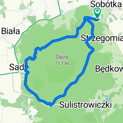
A cycling route starting in Sobótka, Lower Silesian Voivodeship, Poland.
Overview
About this route
Proponowana trasa wiedzie w większości mało uczęszczanymi przez auta drogami, jednakże z uwagi na brak wydzielonych dróg rowerowych należy zachować wzmożoną ostrożność - fragmenty są dosyć ruchliwe. Z wielu miejsc trasy piękne widoki na Masyw Ślęży. Trasa wiedzie przez znaną w okolicy i często odwiedzane przez rowerzystów miejsca jak zalew Mietkowski oraz przełęcz Tąpadła.
- -:--
- Duration
- 62.1 km
- Distance
- 375 m
- Ascent
- 374 m
- Descent
- ---
- Avg. speed
- 378 m
- Avg. speed

Route quality
Waytypes & surfaces along the route
Waytypes
Road
55.1 km
(89 %)
Quiet road
4.4 km
(7 %)
Surfaces
Paved
17.3 km
(28 %)
Unpaved
0.4 km
(<1 %)
Asphalt
17.3 km
(28 %)
Unpaved (undefined)
0.3 km
(<1 %)
Continue with Bikemap
Use, edit, or download this cycling route
You would like to ride Szosowa 60-tka - propozycja trasy od GreeneBikes.pl or customize it for your own trip? Here is what you can do with this Bikemap route:
Free features
- Save this route as favorite or in collections
- Copy & plan your own version of this route
- Sync your route with Garmin or Wahoo
Premium features
Free trial for 3 days, or one-time payment. More about Bikemap Premium.
- Navigate this route on iOS & Android
- Export a GPX / KML file of this route
- Create your custom printout (try it for free)
- Download this route for offline navigation
Discover more Premium features.
Get Bikemap PremiumFrom our community
Other popular routes starting in Sobótka
 1 c tour de sobótka
- Distance
- 44.5 km
- Ascent
- 299 m
- Descent
- 299 m
- Location
- Sobótka, Lower Silesian Voivodeship, Poland
 chujnia po dziurach
- Distance
- 21 km
- Ascent
- 337 m
- Descent
- 337 m
- Location
- Sobótka, Lower Silesian Voivodeship, Poland
 radunia+ślęża
- Distance
- 15.5 km
- Ascent
- 614 m
- Descent
- 614 m
- Location
- Sobótka, Lower Silesian Voivodeship, Poland
 Przy Tamie 4, Borzygniew do Przy Tamie 4, Borzygniew
- Distance
- 18.7 km
- Ascent
- 109 m
- Descent
- 160 m
- Location
- Sobótka, Lower Silesian Voivodeship, Poland
 Pętelka wokół Ślęży czarnym szlakiem
- Distance
- 17.9 km
- Ascent
- 387 m
- Descent
- 387 m
- Location
- Sobótka, Lower Silesian Voivodeship, Poland
 mounting Slenza 😤
- Distance
- 12.1 km
- Ascent
- 563 m
- Descent
- 589 m
- Location
- Sobótka, Lower Silesian Voivodeship, Poland
 tapa wro
- Distance
- 46.4 km
- Ascent
- 71 m
- Descent
- 327 m
- Location
- Sobótka, Lower Silesian Voivodeship, Poland
 Dookoła Ślęży z wjazdem na szczyt
- Distance
- 27.5 km
- Ascent
- 581 m
- Descent
- 580 m
- Location
- Sobótka, Lower Silesian Voivodeship, Poland
Open it in the app