
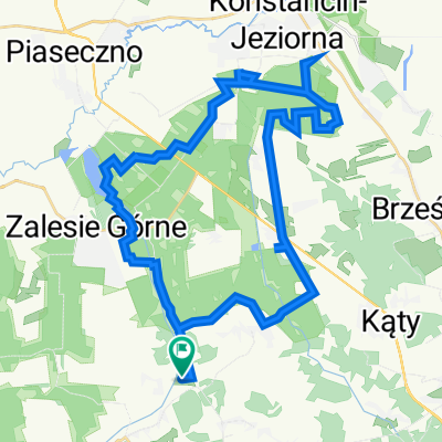
Łbiska - 14 (Kęck)
A cycling route starting in Zalesie Górne, Masovian Voivodeship, Poland.
Overview
About this route
- -:--
- Duration
- 60.6 km
- Distance
- 171 m
- Ascent
- 162 m
- Descent
- ---
- Avg. speed
- 125 m
- Avg. speed

Route quality
Waytypes & surfaces along the route
Waytypes
Quiet road
22.7 km
(38 %)
Road
14.5 km
(24 %)
Surfaces
Paved
45.4 km
(75 %)
Unpaved
8.6 km
(14 %)
Asphalt
41.1 km
(68 %)
Ground
4.2 km
(7 %)
Route highlights
Points of interest along the route
Point of interest after 15.3 km
Tężnia
Point of interest after 15.5 km
Plac zabaw
Point of interest after 15.6 km
Amfiteatr
Point of interest after 15.7 km
Plac zabaw
Point of interest after 27.6 km
Plaża nad Wisłą
Continue with Bikemap
Use, edit, or download this cycling route
You would like to ride Łbiska - 14 (Kęck) or customize it for your own trip? Here is what you can do with this Bikemap route:
Free features
- Save this route as favorite or in collections
- Copy & plan your own version of this route
- Sync your route with Garmin or Wahoo
Premium features
Free trial for 3 days, or one-time payment. More about Bikemap Premium.
- Navigate this route on iOS & Android
- Export a GPX / KML file of this route
- Create your custom printout (try it for free)
- Download this route for offline navigation
Discover more Premium features.
Get Bikemap PremiumFrom our community
Other popular routes starting in Zalesie Górne
 RODOS_G-Rez.Obory_25.07.22
- Distance
- 39.1 km
- Ascent
- 209 m
- Descent
- 212 m
- Location
- Zalesie Górne, Masovian Voivodeship, Poland
 Łbiska - 18 (Biała Góra)
- Distance
- 55.5 km
- Ascent
- 94 m
- Descent
- 92 m
- Location
- Zalesie Górne, Masovian Voivodeship, Poland
 Źródlana, Piaseczno koło Warszawy do Szkolna 2A, Jazgarzew
- Distance
- 12 km
- Ascent
- 97 m
- Descent
- 159 m
- Location
- Zalesie Górne, Masovian Voivodeship, Poland
 Łbiska - 14 (Kęck)
- Distance
- 60.6 km
- Ascent
- 171 m
- Descent
- 162 m
- Location
- Zalesie Górne, Masovian Voivodeship, Poland
 piaseczno - 55km
- Distance
- 55.9 km
- Ascent
- 77 m
- Descent
- 74 m
- Location
- Zalesie Górne, Masovian Voivodeship, Poland
 Mazowiekki bobek do Mechowik
- Distance
- 3.9 km
- Ascent
- 10 m
- Descent
- 8 m
- Location
- Zalesie Górne, Masovian Voivodeship, Poland
 Pętla po Lasach Chojnowskich
- Distance
- 31.2 km
- Ascent
- 136 m
- Descent
- 135 m
- Location
- Zalesie Górne, Masovian Voivodeship, Poland
 Recording from 28 marca, 14:21 proba1
- Distance
- 9.4 km
- Ascent
- 57 m
- Descent
- 57 m
- Location
- Zalesie Górne, Masovian Voivodeship, Poland
Open it in the app