

Scuola Primaria San Salvatore
A cycling route starting in Ospedaletto, Emilia-Romagna, Italy.
Overview
About this route
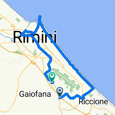
Dalla scuola si svolta a destra su via San Salvatore quindi a sinistra per via Acqualagna e successivamente di nuovo a sinistra per via Barchi. Si prosegue su via Barchi per poi svoltare a sinistra in via fonte Rovescio ed in seguito a destra per via San Salvatore (strada in salita). Si imbocca via San Lorenzo in Correggiano passando di fronte alla chiesa per poi scendere (facendo attenzione alla discesa) in via Acqualagna (incrocio difficile da vedere subito perché in curva). Da via Acqualagna si svolta a sinistra per via Barchi, poi a destra per vi San Salvatore e giungere nuovamente a scuola.
- -:--
- Duration
- 5.3 km
- Distance
- 44 m
- Ascent
- 44 m
- Descent
- ---
- Avg. speed
- 73 m
- Avg. speed

Route quality
Waytypes & surfaces along the route
Waytypes
Quiet road
3.9 km
(72 %)
Road
1.5 km
(28 %)
Undefined
-0 km
(<1 %)
Surfaces
Paved
1.5 km
(28 %)
Asphalt
1.5 km
(28 %)
Undefined
3.9 km
(72 %)
Continue with Bikemap
Use, edit, or download this cycling route
You would like to ride Scuola Primaria San Salvatore or customize it for your own trip? Here is what you can do with this Bikemap route:
Free features
- Save this route as favorite or in collections
- Copy & plan your own version of this route
- Sync your route with Garmin or Wahoo
Premium features
Free trial for 3 days, or one-time payment. More about Bikemap Premium.
- Navigate this route on iOS & Android
- Export a GPX / KML file of this route
- Create your custom printout (try it for free)
- Download this route for offline navigation
Discover more Premium features.
Get Bikemap PremiumFrom our community
Other popular routes starting in Ospedaletto
 Via Sandro Pertini 4, Coriano a Via Monte Olivo 26, Coriano
- Distance
- 6.3 km
- Ascent
- 165 m
- Descent
- 63 m
- Location
- Ospedaletto, Emilia-Romagna, Italy
 san patrignano RSM
- Distance
- 13.9 km
- Ascent
- 496 m
- Descent
- 103 m
- Location
- Ospedaletto, Emilia-Romagna, Italy
 ADriaticoast 2010 Le Saline
- Distance
- 25.4 km
- Ascent
- 575 m
- Descent
- 556 m
- Location
- Ospedaletto, Emilia-Romagna, Italy
 San Marino
- Distance
- 37.5 km
- Ascent
- 742 m
- Descent
- 558 m
- Location
- Ospedaletto, Emilia-Romagna, Italy
 Scuola Primaria Gaiofana
- Distance
- 7.7 km
- Ascent
- 24 m
- Descent
- 24 m
- Location
- Ospedaletto, Emilia-Romagna, Italy
 Riccione-Rimini-Riccione
- Distance
- 38 km
- Ascent
- 188 m
- Descent
- 188 m
- Location
- Ospedaletto, Emilia-Romagna, Italy
 Recovered Route
- Distance
- 27.2 km
- Ascent
- 3 m
- Descent
- 26 m
- Location
- Ospedaletto, Emilia-Romagna, Italy
 Ospedaletto-Acqualagna
- Distance
- 63.3 km
- Ascent
- 1,180 m
- Descent
- 1,059 m
- Location
- Ospedaletto, Emilia-Romagna, Italy
Open it in the app