

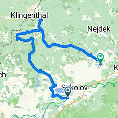
Okruh Michal
A cycling route starting in Dolní Rychnov, Karlovarský kraj, Czechia.
Overview
About this route
<span style="color: rgb(68, 68, 68); font-family: Helvetica, Arial, sans-serif; font-size: 10px; font-weight: bold; line-height: 10px; text-transform: uppercase; background-color: rgb(229, 227, 223);">4.5km</span>
- -:--
- Duration
- 4.5 km
- Distance
- 68 m
- Ascent
- 68 m
- Descent
- ---
- Avg. speed
- ---
- Avg. speed

Route quality
Waytypes & surfaces along the route
Waytypes
Track
2.2 km
(49 %)
Cycleway
1.6 km
(37 %)
Surfaces
Paved
1.8 km
(39 %)
Unpaved
2.1 km
(46 %)
Unpaved (undefined)
1.9 km
(43 %)
Asphalt
1.6 km
(37 %)
Continue with Bikemap
Use, edit, or download this cycling route
You would like to ride Okruh Michal or customize it for your own trip? Here is what you can do with this Bikemap route:
Free features
- Save this route as favorite or in collections
- Copy & plan your own version of this route
- Sync your route with Garmin or Wahoo
Premium features
Free trial for 3 days, or one-time payment. More about Bikemap Premium.
- Navigate this route on iOS & Android
- Export a GPX / KML file of this route
- Create your custom printout (try it for free)
- Download this route for offline navigation
Discover more Premium features.
Get Bikemap PremiumFrom our community
Other popular routes starting in Dolní Rychnov
 uickey 20100726
- Distance
- 76.3 km
- Ascent
- 915 m
- Descent
- 904 m
- Location
- Dolní Rychnov, Karlovarský kraj, Czechia
 VC Sokolova
- Distance
- 8.4 km
- Ascent
- 314 m
- Descent
- 71 m
- Location
- Dolní Rychnov, Karlovarský kraj, Czechia
 Okruh Michal
- Distance
- 4.5 km
- Ascent
- 68 m
- Descent
- 68 m
- Location
- Dolní Rychnov, Karlovarský kraj, Czechia
 uickey 20091120
- Distance
- 46.3 km
- Ascent
- 662 m
- Descent
- 647 m
- Location
- Dolní Rychnov, Karlovarský kraj, Czechia
 uickey 20100712
- Distance
- 33.3 km
- Ascent
- 217 m
- Descent
- 224 m
- Location
- Dolní Rychnov, Karlovarský kraj, Czechia
 Sokolov - Krivoklat
- Distance
- 125.1 km
- Ascent
- 553 m
- Descent
- 726 m
- Location
- Dolní Rychnov, Karlovarský kraj, Czechia
 Cyklostezka Ohře
- Distance
- 104.9 km
- Ascent
- 435 m
- Descent
- 30 m
- Location
- Dolní Rychnov, Karlovarský kraj, Czechia
 Západočeský obchvat
- Distance
- 216.9 km
- Ascent
- 1,393 m
- Descent
- 1,433 m
- Location
- Dolní Rychnov, Karlovarský kraj, Czechia
Open it in the app