

Oster - Radrunde
A cycling route starting in Bannewitz, Saxony, Germany.
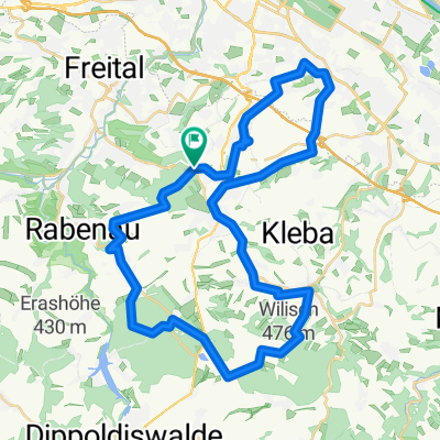
Overview
About this route
Grundlage ist die Hybridkarte da einige Nebenwege (z.B. Elberadweg) dabei ist.
Asphalt und Feldweg, gerade am Anfang und am Ende anspruchsvollere Bergeetappen dabei.
Coschütz - Plauen - Naußlitz - Altgorbitz - Dölzschen - Pesterwitz - Altfranken - Gompitz - Ockerwitz - Zschoner Grund - Briesnitz - Stetzsch (ab hier Elberadweg) - Gohlis - Cossebaude - Niederwartha (über die Brücke) - Kötzschenbroda - Kaditz - Altkaditz - Übigau (Flügelwegbrücke) - Cotta - Löbtau - Plauen - Coschütz
- -:--
- Duration
- 42.7 km
- Distance
- 277 m
- Ascent
- 277 m
- Descent
- ---
- Avg. speed
- ---
- Avg. speed
Route quality
Waytypes & surfaces along the route
Waytypes
Quiet road
13.8 km
(32 %)
Road
6.6 km
(16 %)
Surfaces
Paved
37.1 km
(87 %)
Unpaved
1.9 km
(4 %)
Asphalt
33.3 km
(78 %)
Paving stones
3.2 km
(7 %)
Route highlights
Points of interest along the route
Point of interest after 20.8 km
Gohliser Windmühle
Continue with Bikemap
Use, edit, or download this cycling route
You would like to ride Oster - Radrunde or customize it for your own trip? Here is what you can do with this Bikemap route:
Free features
- Save this route as favorite or in collections
- Copy & plan your own version of this route
- Sync your route with Garmin or Wahoo
Premium features
Free trial for 3 days, or one-time payment. More about Bikemap Premium.
- Navigate this route on iOS & Android
- Export a GPX / KML file of this route
- Create your custom printout (try it for free)
- Download this route for offline navigation
Discover more Premium features.
Get Bikemap PremiumFrom our community
Other popular routes starting in Bannewitz
 Südhöhe-Kaitzbachquelle und zurück
- Distance
- 9.9 km
- Ascent
- 170 m
- Descent
- 190 m
- Location
- Bannewitz, Saxony, Germany
 Etapa 046C (Dresden - Děčín)
- Distance
- 91.8 km
- Ascent
- 869 m
- Descent
- 860 m
- Location
- Bannewitz, Saxony, Germany
 kleine Sonntagsrunde
- Distance
- 23 km
- Ascent
- 337 m
- Descent
- 245 m
- Location
- Bannewitz, Saxony, Germany
 Südhöhe - Rundfahrt
- Distance
- 53.5 km
- Ascent
- 792 m
- Descent
- 747 m
- Location
- Bannewitz, Saxony, Germany
 Die Autobahntour: 34 km Hügel im Dresdner Süden
- Distance
- 33.9 km
- Ascent
- 549 m
- Descent
- 548 m
- Location
- Bannewitz, Saxony, Germany
 Bannewitz - Klingenberg - Malter - Bannewitz
- Distance
- 67.7 km
- Ascent
- 779 m
- Descent
- 727 m
- Location
- Bannewitz, Saxony, Germany
 Radtour Elberadweg
- Distance
- 30.6 km
- Ascent
- 26 m
- Descent
- 32 m
- Location
- Bannewitz, Saxony, Germany
 MTB Tour Windberg, Heidemühle, Wilisch, Windberg CLONED FROM ROUTE 182971
- Distance
- 42.5 km
- Ascent
- 628 m
- Descent
- 662 m
- Location
- Bannewitz, Saxony, Germany
Open it in the app