

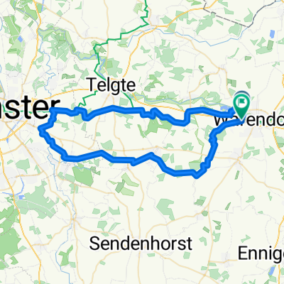
Warendorf-Münster
A cycling route starting in Warendorf, North Rhine-Westphalia, Germany.
Overview
About this route
Eine abwechslungsreiche Tour, die die beiden attraktiven Münsterländer Kreisstädte miteinander und mit Münster verbindet.
Auf den ersten 40 km flach, dann einige kurze, knackige Anstiege in den Baumbergen mit schönen Aussichten.
Wenig bis kein Autoverkehr, meist Asphalt, vor Münster und vor Tilbeck auch kürzere unbefestigte Wegstücke.
Bis Münster folgt der Weg dem Europaradweg R1, danach teilweise abweichend von der Beschilderung.
Bahnanbindung: Regionalbahn Münster-Coesfeld und Münster-Warendorf
- -:--
- Duration
- 27.8 km
- Distance
- 80 m
- Ascent
- 76 m
- Descent
- ---
- Avg. speed
- ---
- Avg. speed
Route quality
Waytypes & surfaces along the route
Waytypes
Quiet road
13.7 km
(49 %)
Access road
5.1 km
(18 %)
Surfaces
Paved
23.7 km
(85 %)
Unpaved
0.9 km
(3 %)
Asphalt
20.4 km
(73 %)
Paving stones
3.2 km
(12 %)
Continue with Bikemap
Use, edit, or download this cycling route
You would like to ride Warendorf-Münster or customize it for your own trip? Here is what you can do with this Bikemap route:
Free features
- Save this route as favorite or in collections
- Copy & plan your own version of this route
- Sync your route with Garmin or Wahoo
Premium features
Free trial for 3 days, or one-time payment. More about Bikemap Premium.
- Navigate this route on iOS & Android
- Export a GPX / KML file of this route
- Create your custom printout (try it for free)
- Download this route for offline navigation
Discover more Premium features.
Get Bikemap PremiumFrom our community
Other popular routes starting in Warendorf
 Emsradweg
- Distance
- 283.5 km
- Ascent
- 60 m
- Descent
- 108 m
- Location
- Warendorf, North Rhine-Westphalia, Germany
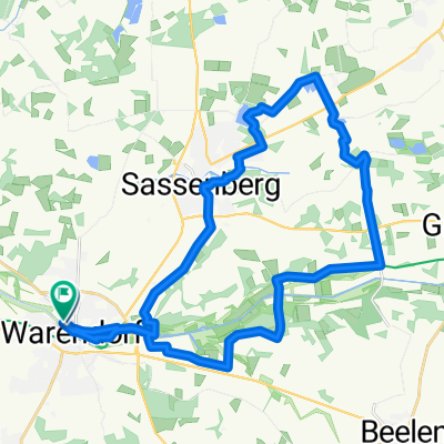 Warendorf - Sassenberg - Rundtour
- Distance
- 30.6 km
- Ascent
- 81 m
- Descent
- 78 m
- Location
- Warendorf, North Rhine-Westphalia, Germany
 Freckenhorst-Müssingen-Telgte-Everswinkel-Cafe Eichenhof-Freckenhorst
- Distance
- 45.5 km
- Ascent
- 142 m
- Descent
- 141 m
- Location
- Warendorf, North Rhine-Westphalia, Germany
 Warendorf- Telgte und zurück
- Distance
- 40.5 km
- Ascent
- 58 m
- Descent
- 62 m
- Location
- Warendorf, North Rhine-Westphalia, Germany
 Grenzweg-1
- Distance
- 69 km
- Ascent
- 93 m
- Descent
- 92 m
- Location
- Warendorf, North Rhine-Westphalia, Germany
 Liener Pass von WAF 55km
- Distance
- 55.8 km
- Ascent
- 214 m
- Descent
- 212 m
- Location
- Warendorf, North Rhine-Westphalia, Germany
 Warendorf-Vinnenberg-Ostbevern-Telgte-Warendorf
- Distance
- 56.5 km
- Ascent
- 146 m
- Descent
- 144 m
- Location
- Warendorf, North Rhine-Westphalia, Germany
 Route in Warendorf
- Distance
- 55.8 km
- Ascent
- 181 m
- Descent
- 179 m
- Location
- Warendorf, North Rhine-Westphalia, Germany
Open it in the app