
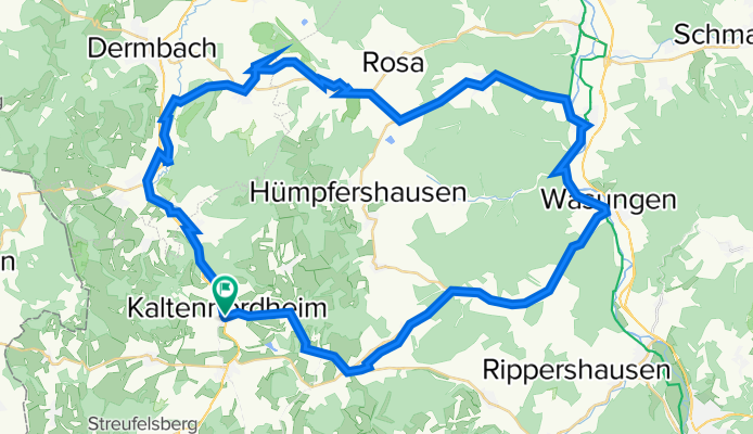
Fuldaer Straße 6, Kaltennordheim nach Fuldaer Straße 3, Kaltennordheim
A cycling route starting in Kaltennordheim, Free State of Thuringia, Germany.
Overview
About this route
- 16 h 23 min
- Duration
- 60.3 km
- Distance
- 181 m
- Ascent
- 231 m
- Descent
- 3.7 km/h
- Avg. speed
- ---
- Avg. speed

Route quality
Waytypes & surfaces along the route
Waytypes
Road
17.4 km
(29 %)
Quiet road
14 km
(23 %)
Surfaces
Paved
32.8 km
(54 %)
Unpaved
5.7 km
(9 %)
Asphalt
31.5 km
(52 %)
Gravel
5.3 km
(9 %)
Continue with Bikemap
Use, edit, or download this cycling route
You would like to ride Fuldaer Straße 6, Kaltennordheim nach Fuldaer Straße 3, Kaltennordheim or customize it for your own trip? Here is what you can do with this Bikemap route:
Free features
- Save this route as favorite or in collections
- Copy & plan your own version of this route
- Sync your route with Garmin or Wahoo
Premium features
Free trial for 3 days, or one-time payment. More about Bikemap Premium.
- Navigate this route on iOS & Android
- Export a GPX / KML file of this route
- Create your custom printout (try it for free)
- Download this route for offline navigation
Discover more Premium features.
Get Bikemap PremiumFrom our community
Other popular routes starting in Kaltennordheim
 Feldabahnstraße 4B, Kaltennordheim nach Föhlritz 8, Brunnhartshausen
- Distance
- 9.7 km
- Ascent
- 222 m
- Descent
- 80 m
- Location
- Kaltennordheim, Free State of Thuringia, Germany
 August-Bebel-Straße 39, Kaltennordheim nach Stedtlinger Weg 5, Rhönblick
- Distance
- 14.1 km
- Ascent
- 160 m
- Descent
- 193 m
- Location
- Kaltennordheim, Free State of Thuringia, Germany
 Feldabahnstraße 4B, Kaltennordheim nach Siedlungstraße 6, Burghaun
- Distance
- 47.8 km
- Ascent
- 439 m
- Descent
- 535 m
- Location
- Kaltennordheim, Free State of Thuringia, Germany
 Gemütliche Route in Kaltennordheim
- Distance
- 12.6 km
- Ascent
- 144 m
- Descent
- 144 m
- Location
- Kaltennordheim, Free State of Thuringia, Germany
 Radclub Feldatal/ Rhön e.V. Einzelzeitfahren für Jedermann in der Rhön
- Distance
- 36.3 km
- Ascent
- 249 m
- Descent
- 250 m
- Location
- Kaltennordheim, Free State of Thuringia, Germany
 Fuldaer Straße 6, Kaltennordheim nach Fuldaer Straße 3, Kaltennordheim
- Distance
- 60.3 km
- Ascent
- 181 m
- Descent
- 231 m
- Location
- Kaltennordheim, Free State of Thuringia, Germany
 Burgweg 18, Kaltennordheim nach Walldorf an der Werra
- Distance
- 23 km
- Ascent
- 200 m
- Descent
- 380 m
- Location
- Kaltennordheim, Free State of Thuringia, Germany
 EZF Kaltennordheim-Weilar-Kaltennordheim
- Distance
- 17.6 km
- Ascent
- 117 m
- Descent
- 219 m
- Location
- Kaltennordheim, Free State of Thuringia, Germany
Open it in the app