

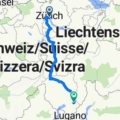
Zürich-Horgen-Siebnen-Sattelegg-Einsiedeln-Unterägeri-Sihltal-Zürich
A cycling route starting in Zürich (Kreis 1), Canton of Zurich, Switzerland.
Overview
About this route
- -:--
- Duration
- 111.5 km
- Distance
- 1,119 m
- Ascent
- 1,117 m
- Descent
- ---
- Avg. speed
- ---
- Avg. speed

Route quality
Waytypes & surfaces along the route
Waytypes
Busy road
48.5 km
(44 %)
Road
26.7 km
(24 %)
Surfaces
Paved
92.3 km
(83 %)
Unpaved
1.6 km
(1 %)
Asphalt
91 km
(82 %)
Ground
1.1 km
(<1 %)
Continue with Bikemap
Use, edit, or download this cycling route
You would like to ride Zürich-Horgen-Siebnen-Sattelegg-Einsiedeln-Unterägeri-Sihltal-Zürich or customize it for your own trip? Here is what you can do with this Bikemap route:
Free features
- Save this route as favorite or in collections
- Copy & plan your own version of this route
- Sync your route with Garmin or Wahoo
Premium features
Free trial for 3 days, or one-time payment. More about Bikemap Premium.
- Navigate this route on iOS & Android
- Export a GPX / KML file of this route
- Create your custom printout (try it for free)
- Download this route for offline navigation
Discover more Premium features.
Get Bikemap PremiumFrom our community
Other popular routes starting in Zürich (Kreis 1)
 KRAJEM VILÉMA TELLA A JEZER ŠVÝCARSKA NA KOLE
- Distance
- 337.2 km
- Ascent
- 2,857 m
- Descent
- 2,481 m
- Location
- Zürich (Kreis 1), Canton of Zurich, Switzerland
 Zeppelin_bici_archibike_Basilea_Zurigo_Lucerna_2015
- Distance
- 384.1 km
- Ascent
- 1,324 m
- Descent
- 1,294 m
- Location
- Zürich (Kreis 1), Canton of Zurich, Switzerland
 Vom Bürkliplatz ZH nach Windlach
- Distance
- 26.9 km
- Ascent
- 227 m
- Descent
- 218 m
- Location
- Zürich (Kreis 1), Canton of Zurich, Switzerland
 Zürich - Rom, 1. Etappe
- Distance
- 197.7 km
- Ascent
- 2,137 m
- Descent
- 2,312 m
- Location
- Zürich (Kreis 1), Canton of Zurich, Switzerland
 Day 1 - Zug
- Distance
- 69.9 km
- Ascent
- 870 m
- Descent
- 863 m
- Location
- Zürich (Kreis 1), Canton of Zurich, Switzerland
 Zürichsee
- Distance
- 94.8 km
- Ascent
- 319 m
- Descent
- 309 m
- Location
- Zürich (Kreis 1), Canton of Zurich, Switzerland
 3SeenTour
- Distance
- 179.2 km
- Ascent
- 930 m
- Descent
- 930 m
- Location
- Zürich (Kreis 1), Canton of Zurich, Switzerland
 Schweizergrenze 1:5_Entwurf_2
- Distance
- 303.4 km
- Ascent
- 2,698 m
- Descent
- 2,697 m
- Location
- Zürich (Kreis 1), Canton of Zurich, Switzerland
Open it in the app