
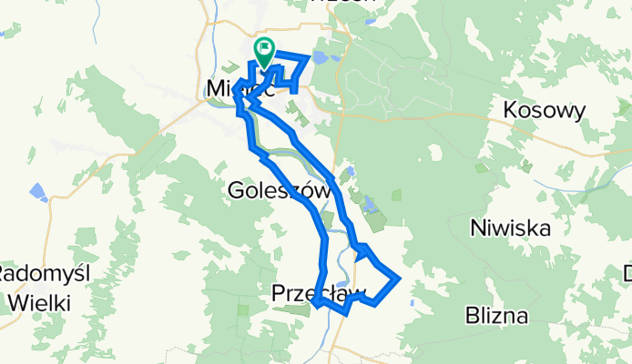
2011_05_21 Rzemień i Przecław
A cycling route starting in Mielec, Subcarpathian Voivodeship, Poland.
Overview
About this route
- -:--
- Duration
- 49.2 km
- Distance
- 42 m
- Ascent
- 45 m
- Descent
- ---
- Avg. speed
- ---
- Avg. speed
Route highlights
Points of interest along the route

Photo after 2.3 km

Photo after 2.7 km

Photo after 4.1 km

Photo after 14.5 km

Photo after 14.9 km

Photo after 22.5 km

Photo after 23.8 km

Photo after 24.9 km

Photo after 25.1 km

Photo after 25.8 km

Photo after 26.1 km

Photo after 32.9 km

Photo after 35.6 km

Photo after 37.2 km

Photo after 37.7 km

Photo after 37.8 km

Photo after 38 km

Photo after 39.4 km

Photo after 41.8 km

Photo after 45.3 km

Photo after 45.7 km

Photo after 46.3 km

Photo after 47.8 km

Photo after 48.8 km
Continue with Bikemap
Use, edit, or download this cycling route
You would like to ride 2011_05_21 Rzemień i Przecław or customize it for your own trip? Here is what you can do with this Bikemap route:
Free features
- Save this route as favorite or in collections
- Copy & plan your own version of this route
- Sync your route with Garmin or Wahoo
Premium features
Free trial for 3 days, or one-time payment. More about Bikemap Premium.
- Navigate this route on iOS & Android
- Export a GPX / KML file of this route
- Create your custom printout (try it for free)
- Download this route for offline navigation
Discover more Premium features.
Get Bikemap PremiumFrom our community
Other popular routes starting in Mielec
 Mielec, Połaniec, Szczucin, Mielec
- Distance
- 83.5 km
- Ascent
- 90 m
- Descent
- 91 m
- Location
- Mielec, Subcarpathian Voivodeship, Poland
 Ujście Wisłoki i dwór w Sadkowej Górze
- Distance
- 51.8 km
- Ascent
- 24 m
- Descent
- 22 m
- Location
- Mielec, Subcarpathian Voivodeship, Poland
 2012/17 Chorzelów - Gawłuszowice - Tuszów Narodowy
- Distance
- 55.9 km
- Ascent
- 27 m
- Descent
- 27 m
- Location
- Mielec, Subcarpathian Voivodeship, Poland
 Zgórsko
- Distance
- 29.1 km
- Ascent
- 78 m
- Descent
- 80 m
- Location
- Mielec, Subcarpathian Voivodeship, Poland
 Kolbuszowa - skansen
- Distance
- 64.1 km
- Ascent
- 154 m
- Descent
- 154 m
- Location
- Mielec, Subcarpathian Voivodeship, Poland
 Czerwona trasa - Nadleśnictwo Mielec
- Distance
- 22.6 km
- Ascent
- 90 m
- Descent
- 86 m
- Location
- Mielec, Subcarpathian Voivodeship, Poland
 Dworki w Chorzelowie i Maliniu
- Distance
- 18.3 km
- Ascent
- 19 m
- Descent
- 19 m
- Location
- Mielec, Subcarpathian Voivodeship, Poland
 wyscig o pietruszkę 10,13,2019
- Distance
- 11.3 km
- Ascent
- 111 m
- Descent
- 111 m
- Location
- Mielec, Subcarpathian Voivodeship, Poland
Open it in the app