

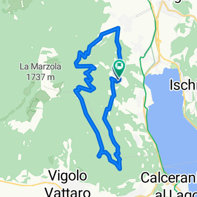
Pergine Valsugana to Viale Armando Diaz 41, Bassano del Grappa
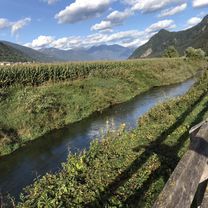
A cycling route starting in Pergine Valsugana, Trentino-Alto Adige, Italy.
Overview
About this route
- 4 h 34 min
- Duration
- 81.1 km
- Distance
- 3,888 m
- Ascent
- 4,251 m
- Descent
- 17.7 km/h
- Avg. speed
- ---
- Avg. speed

Route quality
Waytypes & surfaces along the route
Waytypes
Quiet road
26.7 km
(33 %)
Road
17.8 km
(22 %)
Surfaces
Paved
78.5 km
(97 %)
Asphalt
77.8 km
(96 %)
Paved (undefined)
0.6 km
(<1 %)
Undefined
2.6 km
(3 %)
Continue with Bikemap
Use, edit, or download this cycling route
You would like to ride Pergine Valsugana to Viale Armando Diaz 41, Bassano del Grappa or customize it for your own trip? Here is what you can do with this Bikemap route:
Free features
- Save this route as favorite or in collections
- Copy & plan your own version of this route
- Sync your route with Garmin or Wahoo
Premium features
Free trial for 3 days, or one-time payment. More about Bikemap Premium.
- Navigate this route on iOS & Android
- Export a GPX / KML file of this route
- Create your custom printout (try it for free)
- Download this route for offline navigation
Discover more Premium features.
Get Bikemap PremiumFrom our community
Other popular routes starting in Pergine Valsugana
 v277 ciclabile Valsugana - PERGINE - BASSANO (pisteciclabili)
- Distance
- 82.1 km
- Ascent
- 147 m
- Descent
- 501 m
- Location
- Pergine Valsugana, Trentino-Alto Adige, Italy
 VS_ Pergine - Bassano del Grappa
- Distance
- 85.4 km
- Ascent
- 193 m
- Descent
- 552 m
- Location
- Pergine Valsugana, Trentino-Alto Adige, Italy
 Giro del castello e lago (via Tenna)
- Distance
- 25.4 km
- Ascent
- 255 m
- Descent
- 253 m
- Location
- Pergine Valsugana, Trentino-Alto Adige, Italy
 20191005 Valsugana da S.Cristoforo a Novaledo
- Distance
- 16.2 km
- Ascent
- 59 m
- Descent
- 90 m
- Location
- Pergine Valsugana, Trentino-Alto Adige, Italy
 giro dei piani di susa e bosentino.
- Distance
- 13.6 km
- Ascent
- 1,195 m
- Descent
- 660 m
- Location
- Pergine Valsugana, Trentino-Alto Adige, Italy
 Giro della Marzola
- Distance
- 24.9 km
- Ascent
- 978 m
- Descent
- 978 m
- Location
- Pergine Valsugana, Trentino-Alto Adige, Italy
 Pergine - Bassano
- Distance
- 79 km
- Ascent
- 253 m
- Descent
- 587 m
- Location
- Pergine Valsugana, Trentino-Alto Adige, Italy
 CALDONAZZO-MANGHEN-BEDOLLO
- Distance
- 108.8 km
- Ascent
- 2,025 m
- Descent
- 2,023 m
- Location
- Pergine Valsugana, Trentino-Alto Adige, Italy
Open it in the app