![竹北夜騎路線[興隆路->高鐵]](/_next/static/media/contour-lines-light-small.cafd5e5d.avif)
![竹北夜騎路線[興隆路->高鐵]](https://media.bikemap.net/routes/98839/staticmaps/in_80564158-993e-4cb6-8f74-2847073ae413_694x400_bikemap-2021-3D-static.png)
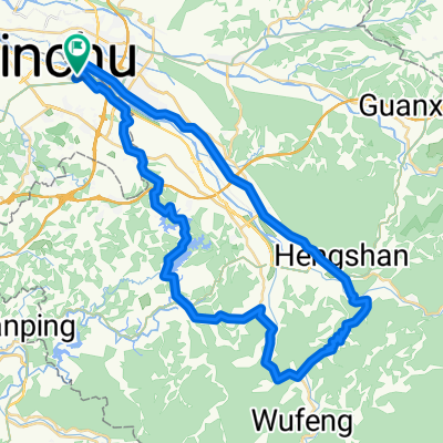
竹北夜騎路線[興隆路->高鐵]
A cycling route starting in Zhubei, Taiwan, Taiwan.
Overview
About this route
興隆路->高鐵
- -:--
- Duration
- 12.1 km
- Distance
- 45 m
- Ascent
- 55 m
- Descent
- ---
- Avg. speed
- ---
- Avg. speed

Continue with Bikemap
Use, edit, or download this cycling route
You would like to ride 竹北夜騎路線[興隆路->高鐵] or customize it for your own trip? Here is what you can do with this Bikemap route:
Free features
- Save this route as favorite or in collections
- Copy & plan your own version of this route
- Sync your route with Garmin or Wahoo
Premium features
Free trial for 3 days, or one-time payment. More about Bikemap Premium.
- Navigate this route on iOS & Android
- Export a GPX / KML file of this route
- Create your custom printout (try it for free)
- Download this route for offline navigation
Discover more Premium features.
Get Bikemap PremiumFrom our community
Other popular routes starting in Zhubei
 2009 Lander單車環島行
- Distance
- 1,065.2 km
- Ascent
- 1,602 m
- Descent
- 1,604 m
- Location
- Zhubei, Taiwan, Taiwan
 Hukou_1
- Distance
- 21.6 km
- Ascent
- 320 m
- Descent
- 323 m
- Location
- Zhubei, Taiwan, Taiwan
 FormFactor Cycling Taiwan Plan
- Distance
- 930.1 km
- Ascent
- 1,919 m
- Descent
- 1,918 m
- Location
- Zhubei, Taiwan, Taiwan
 2009/12/19 大山背/北埔/寶一二水庫
- Distance
- 64.2 km
- Ascent
- 1,244 m
- Descent
- 1,179 m
- Location
- Zhubei, Taiwan, Taiwan
 竹北~ 大山背~關西~新埔~竹北
- Distance
- 66.6 km
- Ascent
- 1,340 m
- Descent
- 1,307 m
- Location
- Zhubei, Taiwan, Taiwan
 湖口後山停車場
- Distance
- 14.3 km
- Ascent
- 489 m
- Descent
- 217 m
- Location
- Zhubei, Taiwan, Taiwan
 縣政二十一街101巷 19, 竹北市到台3線 97, 橫山鄉
- Distance
- 19.5 km
- Ascent
- 225 m
- Descent
- 97 m
- Location
- Zhubei, Taiwan, Taiwan
 中等路線 竹北市夜騎路線
- Distance
- 23.2 km
- Ascent
- 187 m
- Descent
- 183 m
- Location
- Zhubei, Taiwan, Taiwan
Open it in the app