

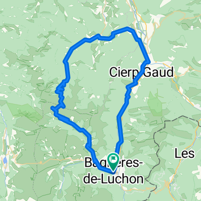
18-J. Bagnères-de-Luchon - Hautacam (121,6 Km)
A cycling route starting in Bagnères-de-Luchon, Languedoc-Roussillon-Midi-Pyrénées, France.
Overview
About this route
- -:--
- Duration
- 121.6 km
- Distance
- 4,678 m
- Ascent
- 3,683 m
- Descent
- ---
- Avg. speed
- 2,119 m
- Avg. speed
Route quality
Waytypes & surfaces along the route
Waytypes
Busy road
104.3 km
(86 %)
Road
10.8 km
(9 %)
Surfaces
Paved
99.2 km
(82 %)
Unpaved
0.5 km
(<1 %)
Asphalt
99.2 km
(82 %)
Ground
0.5 km
(<1 %)
Undefined
21.9 km
(18 %)
Route highlights
Points of interest along the route
Point of interest after 15.3 km
Col de PEYRESOURDE (1) Km. XXXX Altitude: XXXXX m XX Km at XX%
Point of interest after 47.3 km
Col d'ASPIN (1) Km. 46,9 Altitude: XXXXX m XX Km at XX%
Point of interest after 76.3 km
Col du TOURMALET (HC) Km. 76,2 Altitude: XXXXX m XX Km at XX%
Continue with Bikemap
Use, edit, or download this cycling route
You would like to ride 18-J. Bagnères-de-Luchon - Hautacam (121,6 Km) or customize it for your own trip? Here is what you can do with this Bikemap route:
Free features
- Save this route as favorite or in collections
- Copy & plan your own version of this route
- Sync your route with Garmin or Wahoo
Premium features
Free trial for 3 days, or one-time payment. More about Bikemap Premium.
- Navigate this route on iOS & Android
- Export a GPX / KML file of this route
- Create your custom printout (try it for free)
- Download this route for offline navigation
Discover more Premium features.
Get Bikemap PremiumFrom our community
Other popular routes starting in Bagnères-de-Luchon
 Catalunya divide
- Distance
- 421.7 km
- Ascent
- 4,580 m
- Descent
- 5,170 m
- Location
- Bagnères-de-Luchon, Languedoc-Roussillon-Midi-Pyrénées, France
 Pirinei-05a
- Distance
- 107.3 km
- Ascent
- 1,968 m
- Descent
- 1,917 m
- Location
- Bagnères-de-Luchon, Languedoc-Roussillon-Midi-Pyrénées, France
 Port de Bales
- Distance
- 69.3 km
- Ascent
- 1,395 m
- Descent
- 1,395 m
- Location
- Bagnères-de-Luchon, Languedoc-Roussillon-Midi-Pyrénées, France
 Bagneres de Luchon-Col de Peyresourde-Col D´Aspin-Bagneres de Luchon
- Distance
- 160.4 km
- Ascent
- 2,395 m
- Descent
- 2,395 m
- Location
- Bagnères-de-Luchon, Languedoc-Roussillon-Midi-Pyrénées, France
 Pirinei-05
- Distance
- 98 km
- Ascent
- 2,812 m
- Descent
- 2,943 m
- Location
- Bagnères-de-Luchon, Languedoc-Roussillon-Midi-Pyrénées, France
 2012-09---7 bis 8-tage radtour in den pyrenaeen
- Distance
- 489.2 km
- Ascent
- 7,694 m
- Descent
- 7,678 m
- Location
- Bagnères-de-Luchon, Languedoc-Roussillon-Midi-Pyrénées, France
 Tour des Criminels
- Distance
- 306.6 km
- Ascent
- 4,325 m
- Descent
- 4,955 m
- Location
- Bagnères-de-Luchon, Languedoc-Roussillon-Midi-Pyrénées, France
 La Route des Cols - Etapa 6 - Cierp-Gaud - Aulus - Les - Bains
- Distance
- 80 km
- Ascent
- 2,170 m
- Descent
- 2,158 m
- Location
- Bagnères-de-Luchon, Languedoc-Roussillon-Midi-Pyrénées, France
Open it in the app