
My saved routes
A collection of 15 cycling routes, created by Thomas Notter.
Overview
About this collection
This collection contains all routes that were previously saved.
- 15
- Routes
- -:--
- Duration
- 631 km
- Distance
- ---
- Avg. speed
- 7,132 m
- Ascent
- 6,218 m
- Descent

created this 9 years ago
My saved routes
Routes in this collection
All 15 routes in this collection can be opened on the map or in the Bikemap App for more details, where you can adjust them in the route planner, or download them as GPX or KML file. Use them as a template for planning your own rides, or let Bikemap navigate you along them directly.

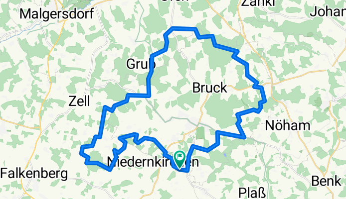
Niederbayerntrail & Holzland
Cycling route in Falkenberg, Bavaria, Germany
- 53.6 km
- Distance
- 461 m
- Ascent
- 544 m
- Descent
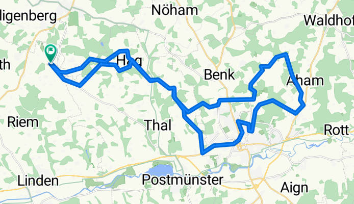
Holzhamm - Pfarrkirchen - Holzhamm
Cycling route in Schönau, Bavaria, Germany
- 34.9 km
- Distance
- 481 m
- Ascent
- 483 m
- Descent

Route 1 Simbach - Ecken - Satzenberg - Irging - Hadermann
Cycling route in Simbach am Inn, Bavaria, Germany
- 21.8 km
- Distance
- 348 m
- Ascent
- 303 m
- Descent

Plauen Kuhberg Plauen
Cycling route in Plauen, Saxony, Germany
- 48.1 km
- Distance
- 565 m
- Ascent
- 565 m
- Descent

Auerbach Hammerbrücke Rautengranz Grünheide Schnarrtanne Rodewisch Auerbach
Cycling route in Auerbach, Saxony, Germany
- 47.3 km
- Distance
- 655 m
- Ascent
- 672 m
- Descent

Auerbach-Schönheide-Kuhberg-Wernesgrün-Rodewisch
Cycling route in Auerbach, Saxony, Germany
- 33.6 km
- Distance
- 573 m
- Ascent
- 549 m
- Descent

MTB Runde rund ums Crinitztal
Cycling route in Wilkau-Haßlau, Saxony, Germany
- 41 km
- Distance
- 503 m
- Ascent
- 503 m
- Descent

Juchhöh
Cycling route in Hirschfeld, Saxony, Germany
- 30.5 km
- Distance
- 449 m
- Ascent
- 223 m
- Descent

Greiz Hütte
Cycling route in Greiz, Thuringia, Germany
- 37.4 km
- Distance
- 542 m
- Ascent
- 213 m
- Descent

Reichenbach - Kraslice
Cycling route in Reichenbach/Vogtland, Saxony, Germany
- 72.6 km
- Distance
- 736 m
- Ascent
- 570 m
- Descent

Gera-Zwei-Täler-Route
Cycling route in Gera, Thuringia, Germany
- 37.1 km
- Distance
- 254 m
- Ascent
- 249 m
- Descent