
My saved routes
A collection of 10 cycling routes, created by Enrique Peregrino.
Overview
About this collection
This collection contains all routes that were previously saved.
- 10
- Routes
- -:--
- Duration
- 1,149.1 km
- Distance
- ---
- Avg. speed
- 2,222 m
- Ascent
- 2,047 m
- Descent

created this 9 years ago
My saved routes
Routes in this collection
All 10 routes in this collection can be opened on the map or in the Bikemap App for more details, where you can adjust them in the route planner, or download them as GPX or KML file. Use them as a template for planning your own rides, or let Bikemap navigate you along them directly.

Über die Himmelsleiter zum Kloster Kamp und zuück über den Kapuzinerberg
Cycling route in Krefeld, North Rhine-Westphalia, Germany
- 66.9 km
- Distance
- 106 m
- Ascent
- 105 m
- Descent

EM-Route zum 1. Spiel
Cycling route in Tönisvorst, North Rhine-Westphalia, Germany
- 320 km
- Distance
- 305 m
- Ascent
- 308 m
- Descent

EM-Route
Cycling route in Tönisvorst, North Rhine-Westphalia, Germany
- 315.8 km
- Distance
- 243 m
- Ascent
- 248 m
- Descent

DE 2 Mönchengladbach > Luik
Cycling route in Mönchengladbach, North Rhine-Westphalia, Germany
- 108.8 km
- Distance
- 636 m
- Ascent
- 518 m
- Descent

Bahntrassenradeln Dülken Born
Cycling route in Mönchengladbach, North Rhine-Westphalia, Germany
- 47.6 km
- Distance
- 102 m
- Ascent
- 101 m
- Descent

Bahntrassenradeln Viersen
Cycling route in Mönchengladbach, North Rhine-Westphalia, Germany
- 52.1 km
- Distance
- 70 m
- Ascent
- 72 m
- Descent

france 2009-10 sens-auxerre
Cycling route in Sens, Bourgogne-Franche-Comté, France
- 65.2 km
- Distance
- 285 m
- Ascent
- 257 m
- Descent
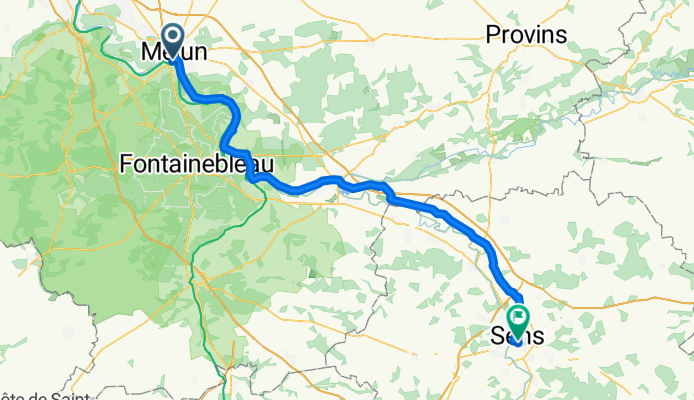
france 2009-10 melun-sens
Cycling route in Melun, Île-de-France Region, France
- 78 km
- Distance
- 173 m
- Ascent
- 149 m
- Descent

Vallorbe - Paris, Tag 15 (Villeneuve-sur-Yonne - Montereau)
Cycling route in Villeneuve-sur-Yonne, Bourgogne-Franche-Comté, France
- 66.5 km
- Distance
- 105 m
- Ascent
- 126 m
- Descent

Camino 2015 03a Toul nach Vaucouleurs
Cycling route in Toul, Grand Est, France
- 28.2 km
- Distance
- 197 m
- Ascent
- 163 m
- Descent