
My saved routes
A collection of 4 cycling routes, created by Eduardo Agustin Bayot.
Overview
About this collection
This collection contains all routes that were previously saved.
- 4
- Routes
- -:--
- Duration
- 1,492.3 km
- Distance
- ---
- Avg. speed
- 535 m
- Ascent
- 693 m
- Descent
Eduardo Agustin Bayot
created this 9 years ago
My saved routes
Routes in this collection
All 4 routes in this collection can be opened on the map or in the Bikemap App for more details, where you can adjust them in the route planner, or download them as GPX or KML file. Use them as a template for planning your own rides, or let Bikemap navigate you along them directly.

Del Vial Costero hasta Puerto Parana (Partido de Escobar) pasando por Villa La Ñata
Del Vial Costero hasta Puerto Parana (Partido de Escobar) pasando por Villa La Ñata
- 115.2 km
- Distance
- 108 m
- Ascent
- 108 m
- Descent
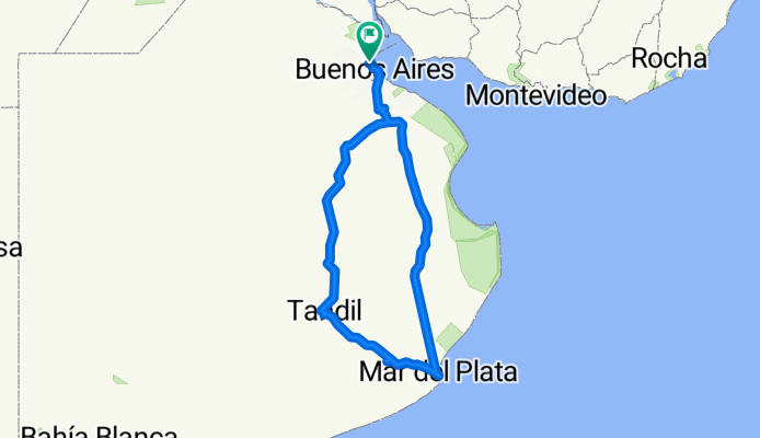
1000km de la Pcia de Buenos Aires en bici
Cycling route in Olivos, Buenos Aires, Argentina
For my summer vacation 2010, I made the decision to undertake this adventure of covering over 1000km on a solo trip by bicycle through the Province of Buenos Aires; I did it connecting my city of Olivos with Tandil, Mar del Plata, and back to Olivos. I did it aboard a mountain bike Zenith Sala 2007…
- 1,041.4 km
- Distance
- 300 m
- Ascent
- 302 m
- Descent

Punta Indio - La plata Ruta 11
Cycling route in Verónica, Buenos Aires, Argentina
The shortest way back to La Plata; a third, up to Magdalena, on dirt road (Conchillas) with a saw included, if it hasn’t rained in the last few days it’s not so terrible. Then 50 km of pavement that is sometimes deteriorated. There wasn’t much traffic (except entering La Plata). One detail to consi…
- 86 km
- Distance
- 86 m
- Ascent
- 71 m
- Descent

Tandil - Pinamar
Cycling route in Tandil, Buenos Aires, Argentina
Approximately 250 km.
2 intense days and a quiet stretch of 30k from Madariaga to Pinamar.
Up to Madariaga is all dirt road, with no traffic, pure fields and pampa. Then from Madariaga to Pinamar, it's via the highway because no internal roads were found.
Water can be taken from the windmills in th…
- 249.7 km
- Distance
- 41 m
- Ascent
- 212 m
- Descent