
My saved routes
A collection of 12 cycling routes, created by RADFAHRER.
Overview
About this collection
This collection contains all routes that were previously saved.
- 12
- Routes
- -:--
- Duration
- 584.8 km
- Distance
- ---
- Avg. speed
- 1,688 m
- Ascent
- 1,720 m
- Descent
created this 9 years ago
My saved routes
Routes in this collection
All 12 routes in this collection can be opened on the map or in the Bikemap App for more details, where you can adjust them in the route planner, or download them as GPX or KML file. Use them as a template for planning your own rides, or let Bikemap navigate you along them directly.

flensburg schwabstedt
Cycling route in Flensburg, Schleswig-Holstein, Germany
- 54.6 km
- Distance
- 95 m
- Ascent
- 126 m
- Descent


Flensburg - Westerholz - Rundreise für den Nachmittag
Cycling route in Flensburg, Schleswig-Holstein, Germany
- 47.2 km
- Distance
- 201 m
- Ascent
- 202 m
- Descent

Waterkant Permanente RSC Oeversee
Cycling route in Glücksburg, Schleswig-Holstein, Germany
- 72.6 km
- Distance
- 384 m
- Ascent
- 366 m
- Descent

Rundling und Riese
Cycling route in Bodenteich, Lower Saxony, Germany
- 24.5 km
- Distance
- 50 m
- Ascent
- 54 m
- Descent

Alte Ritter wilde Pferde
Cycling route in Bodenteich, Lower Saxony, Germany
- 45.2 km
- Distance
- 86 m
- Ascent
- 86 m
- Descent

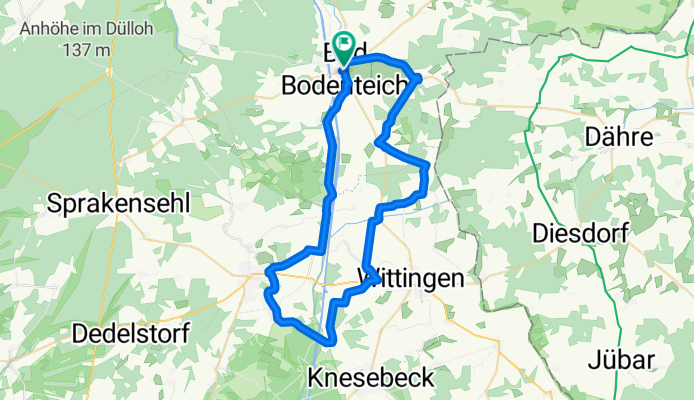
Ottertour
Cycling route in Bodenteich, Lower Saxony, Germany
- 50.9 km
- Distance
- 142 m
- Ascent
- 143 m
- Descent

Wassertour (neu)
Cycling route in Bodenteich, Lower Saxony, Germany
- 67.9 km
- Distance
- 200 m
- Ascent
- 200 m
- Descent

Bäckertour
Cycling route in Bodenteich, Lower Saxony, Germany
- 46 km
- Distance
- 136 m
- Ascent
- 136 m
- Descent

Rittertour
Cycling route in Bodenteich, Lower Saxony, Germany
- 49.8 km
- Distance
- 138 m
- Ascent
- 136 m
- Descent
Süd Tour „Otterzentrum nach Hankensbüttel“
Cycling route in Bodenteich, Lower Saxony, Germany
- 47.6 km
- Distance
- 75 m
- Ascent
- 67 m
- Descent

fürstenberg
Cycling route in Neustrelitz, Mecklenburg-Vorpommern, Germany
- 28.3 km
- Distance
- 84 m
- Ascent
- 106 m
- Descent