
My saved routes
A collection of 15 cycling routes, created by Simon Andor.
Overview
About this collection
This collection contains all routes that were previously saved.
- 15
- Routes
- -:--
- Duration
- 1,328.1 km
- Distance
- ---
- Avg. speed
- 22,254 m
- Ascent
- 23,373 m
- Descent

created this 9 years ago
My saved routes
Routes in this collection
All 15 routes in this collection can be opened on the map or in the Bikemap App for more details, where you can adjust them in the route planner, or download them as GPX or KML file. Use them as a template for planning your own rides, or let Bikemap navigate you along them directly.

Salgótarján- Tachty tó
Cycling route in Salgótarján, Nógrád megye, Hungary
- 81.3 km
- Distance
- 736 m
- Ascent
- 737 m
- Descent

okruh Modra-Solosnica
Cycling route in Modra, Bratislava Region, Slovakia
- 72.5 km
- Distance
- 1,497 m
- Ascent
- 1,390 m
- Descent

Bakonyi kerekezés
Cycling route in Zirc, Veszprém megye, Hungary
- 67.4 km
- Distance
- 1,260 m
- Ascent
- 1,208 m
- Descent

SELLA RONDA na handbiku 25.7.2010
Cycling route in Corvara, Trentino-Alto Adige, Italy
- 52.1 km
- Distance
- 1,632 m
- Ascent
- 1,626 m
- Descent
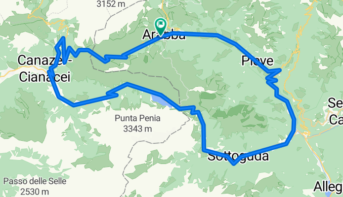
Arabba - Marmolada
Cycling route in Corvara, Trentino-Alto Adige, Italy
- 65.1 km
- Distance
- 1,934 m
- Ascent
- 1,934 m
- Descent

Arabba - S. Pellegrino
Cycling route in Corvara, Trentino-Alto Adige, Italy
- 99.9 km
- Distance
- 2,209 m
- Ascent
- 2,209 m
- Descent

Kemping -Vár - Villach -Kemping
Cycling route in Wernberg, Carinthia, Austria
- 23.1 km
- Distance
- 260 m
- Ascent
- 260 m
- Descent

Gerlitzen - Klösterle - Feldkirchen ik.- Ossiach
Cycling route in Arriach, Carinthia, Austria
- 62.2 km
- Distance
- 319 m
- Ascent
- 1,689 m
- Descent

Bükk terv
Cycling route in Sajóbábony, Borsod-Abauj Zemplen county, Hungary
- 137.6 km
- Distance
- 1,959 m
- Ascent
- 1,959 m
- Descent

Training route 7
Cycling route in Bonyhád, Tolna County, Hungary
- 136.3 km
- Distance
- 1,001 m
- Ascent
- 1,001 m
- Descent

Banska Stiavnica okruh 03
Cycling route in Banská Štiavnica, Banská Bystrica Region, Slovakia
- 109.4 km
- Distance
- 2,593 m
- Ascent
- 2,503 m
- Descent

Rund um die Ossiacher Tauern CLONED FROM ROUTE 88573
Cycling route in Villach, Carinthia, Austria
- 60.5 km
- Distance
- 370 m
- Ascent
- 372 m
- Descent