
Glandorf's offizielle Fahrradrouten
A collection of 10 cycling routes, created by TheRoDamAs.
Overview
About this collection
Fahrradrouten die durch das Glandorfer Gemeindegebiet führen
- 11
- Routes
- -:--
- Duration
- 3,265.6 km
- Distance
- ---
- Avg. speed
- 3,529 m
- Ascent
- 3,536 m
- Descent

Glandorf's offizielle Fahrradrouten
Routes in this collection
All 10 routes in this collection can be opened on the map or in the Bikemap App for more details, where you can adjust them in the route planner, or download them as GPX or KML file. Use them as a template for planning your own rides, or let Bikemap navigate you along them directly.

Sole u. Kneipp-Tour
Cycling route in Bad Rothenfelde, Lower Saxony, Germany
- 50 km
- Distance
- 231 m
- Ascent
- 231 m
- Descent

Friedensroute Münster - Osnabrück
Cycling route in Osnabrück, Lower Saxony, Germany
- 176.4 km
- Distance
- 323 m
- Ascent
- 263 m
- Descent

Niedersächsische Mühlen-Tour
Cycling route in Bramsche, Lower Saxony, Germany
- 394.4 km
- Distance
- 674 m
- Ascent
- 674 m
- Descent

Spargelroute Glandorf
Cycling route in Glandorf, Lower Saxony, Germany
- 23 km
- Distance
- 41 m
- Ascent
- 41 m
- Descent

Glandorf - Bad Laer
Cycling route in Glandorf, Lower Saxony, Germany
- 23 km
- Distance
- 43 m
- Ascent
- 43 m
- Descent
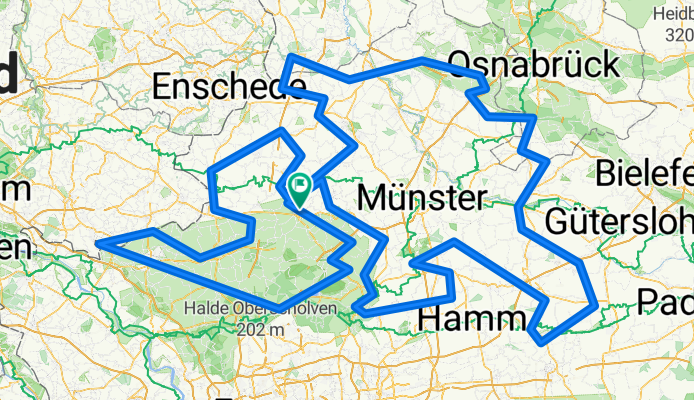
100 Schlösser Route komplett Außen
Cycling route in Coesfeld, North Rhine-Westphalia, Germany
- 814 km
- Distance
- 459 m
- Ascent
- 459 m
- Descent

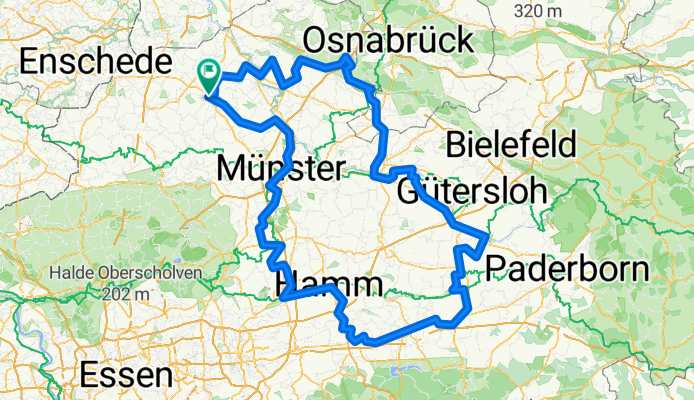
100 Schlösser Route - Nordkurs
Cycling route in Billerbeck, North Rhine-Westphalia, Germany
- 295 km
- Distance
- 464 m
- Ascent
- 464 m
- Descent

Deutsche Fußball-Route Nrw.gpx
Cycling route in Aachen, North Rhine-Westphalia, Germany
- 804.7 km
- Distance
- 701 m
- Ascent
- 768 m
- Descent
Historische Stadtkerne
Cycling route in Steinfurt, North Rhine-Westphalia, Germany
- 383.2 km
- Distance
- 401 m
- Ascent
- 401 m
- Descent

Grenzgängerroute Teuto-Ems
Cycling route in Glandorf, Lower Saxony, Germany
- 146.5 km
- Distance
- 192 m
- Ascent
- 192 m
- Descent