
My saved routes
A collection of 13 cycling routes, created by st!d.OverviewAbout this collection
This collection contains all routes that were previously saved.
- 13
- Routes
- -:--
- Duration
- 434.9 km
- Distance
- ---
- Avg. speed
- 10,284 m
- Ascent
- 11,036 m
- Descent
st!dcreated this 9 years ago

Flims/Laax, MTB, Tour Nr.247
Cycling route in Flims, Grisons, Switzerland
Vom Flims ging es über Nagens hinauf zum Vorab Gletscher - ~1500
Höhenmeter am Stück (!). Vom Vorab wieder zurück nach Nagens und dann
über den Grauberg ins Tal.Konditionell
Anspruchvolle Tour mit fantastisches Panorama; leider beginnen die
Trails erst auf der zweiten Hälfte der Abfahrt vom Grauber…
- 33.4 km
- Distance
- 1,611 m
- Ascent
- 1,611 m
- Descent

Hapimag - Il Spir - Cresta See - Hapimag
Cycling route in Flims, Grisons, Switzerland
27.05.13 15:32
- 12.6 km
- Distance
- 394 m
- Ascent
- 400 m
- Descent

Murschetg Stargels Roundtrip
Cycling route in Flims, Grisons, Switzerland
- 15.8 km
- Distance
- 647 m
- Ascent
- 647 m
- Descent

Ruinaulta-Rundtour
Cycling route in Flims, Grisons, Switzerland
beautiful round trip around the Rhine Gorge with cozy viewpoints.
- 49.3 km
- Distance
- 1,105 m
- Ascent
- 1,105 m
- Descent

Uster-Schloss
Cycling route in Uster / Kirch-Uster, Canton of Zurich, Switzerland
- 56 km
- Distance
- 964 m
- Ascent
- 964 m
- Descent

Mönchaltorf - Egg - Guldenen - Forch - Maur - Mönchaltorf
Cycling route in Mönchaltorf, Canton of Zurich, Switzerland
09.06.13 15:07
- 25.3 km
- Distance
- 399 m
- Ascent
- 399 m
- Descent

Bernina Express (St. Moritz - Bernina - Poschiavo)
Cycling route in St. Moritz, Grisons, Switzerland
- 35.5 km
- Distance
- 578 m
- Ascent
- 1,329 m
- Descent

Titisee-Schluchsee_2
Cycling route in Schluchsee, Baden-Wurttemberg, Germany
From Titisee to Schluchsee and back
- 45.3 km
- Distance
- 1,153 m
- Ascent
- 1,153 m
- Descent

Schluchsee Äule Fischbach
Cycling route in Schluchsee, Baden-Wurttemberg, Germany
- 34.3 km
- Distance
- 669 m
- Ascent
- 669 m
- Descent
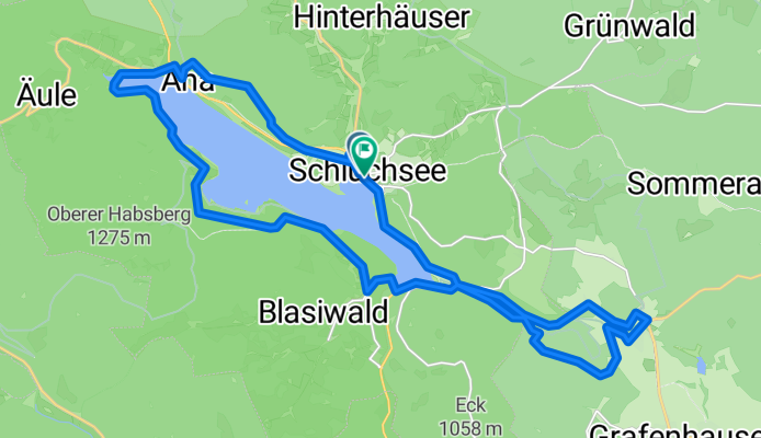
Rund um den Schluchsee nach Rothaus
Cycling route in Schluchsee, Baden-Wurttemberg, Germany
- 27.9 km
- Distance
- 508 m
- Ascent
- 504 m
- Descent

Wolfsgrund - Rothaus - Unterkrummen
Cycling route in Schluchsee, Baden-Wurttemberg, Germany
- 28.4 km
- Distance
- 452 m
- Ascent
- 444 m
- Descent


5 Töbeli (Uster - Egg - Meilen - Herrliberg - Erlenbach - Küsnacht - Guldenen - Uster)
Cycling route in Uster / Kirch-Uster, Canton of Zurich, Switzerland
Little gem at Pfannenstiel!
Beautiful mountain bike tour through three different Töbeli on Lake Zurich from Meilen to Küsnacht.
The first steep section from Uster to Pfannenstiel could also be skipped by starting at the upper lower Pfannenstiel parking lot.
The singletrack from Pfannenstiel migh…
- 49 km
- Distance
- 1,076 m
- Ascent
- 1,076 m
- Descent