
2017 Auvergne
A collection of 23 cycling routes, created by Andreas Stalla.
Overview
About this collection
4 wöchige Trekkingtour durch die Auvergne
- 23
- Routes
- -:--
- Duration
- 1,234.1 km
- Distance
- ---
- Avg. speed
- 17,891 m
- Ascent
- 18,207 m
- Descent

created this 6 years ago
2017 Auvergne
Routes in this collection
All 23 routes in this collection can be opened on the map or in the Bikemap App for more details, where you can adjust them in the route planner, or download them as GPX or KML file. Use them as a template for planning your own rides, or let Bikemap navigate you along them directly.

Clermont-Ferrand - Orcival
Cycling route in Clermont-Ferrand, Auvergne-Rhône-Alpes, France
- 37.3 km
- Distance
- 986 m
- Ascent
- 425 m
- Descent

Orcival - Murol
Cycling route in Gelles, Auvergne-Rhône-Alpes, France
- 51.4 km
- Distance
- 888 m
- Ascent
- 1,008 m
- Descent

Murol - Blesle
Cycling route in Aydat, Auvergne-Rhône-Alpes, France
- 77.7 km
- Distance
- 1,014 m
- Ascent
- 1,308 m
- Descent

Blesle - Mandailles-Saint-Julien
Cycling route in Massiac, Auvergne-Rhône-Alpes, France
- 74.6 km
- Distance
- 1,472 m
- Ascent
- 1,036 m
- Descent
Mandailles-Saint-Julien - Salers
Cycling route in Vic-sur-Cère, Auvergne-Rhône-Alpes, France
- 43.1 km
- Distance
- 776 m
- Ascent
- 752 m
- Descent

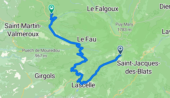
Salers - Saint-Jacques-des-Blats
Cycling route in Saint-Cernin, Auvergne-Rhône-Alpes, France
- 43.4 km
- Distance
- 1,042 m
- Ascent
- 1,052 m
- Descent

Saint-Jacques-des-Blats - Saint-Amans-des-Cots
Cycling route in Vic-sur-Cère, Auvergne-Rhône-Alpes, France
- 68.7 km
- Distance
- 1,159 m
- Ascent
- 1,414 m
- Descent

Saint-Amans-des-Cots Runde
Cycling route in Entraygues-sur-Truyère, Occitanie, France
- 25.9 km
- Distance
- 302 m
- Ascent
- 307 m
- Descent


Saint-Amans-des-Cots - Conques
Cycling route in Entraygues-sur-Truyère, Occitanie, France
- 56.6 km
- Distance
- 784 m
- Ascent
- 1,267 m
- Descent


Brasc - Belmount-sur-Rance
Cycling route in Réquista, Occitanie, France
- 42.6 km
- Distance
- 641 m
- Ascent
- 673 m
- Descent