
2009 Transpirenaicas
A collection of 14 cycling routes, created by Manuel Sabaté.OverviewAbout this collection
This route collection contains 14 cycling routes
with a total length of 697.5 km.
- 14
- Routes
- -:--
- Duration
- 697.5 km
- Distance
- ---
- Avg. speed
- 18,570 m
- Ascent
- 16,815 m
- Descent
Manuel Sabatécreated this 5 years ago

Luz - Arreau
Cycling route in Luz-Saint-Sauveur, Occitanie, France
- 56.7 km
- Distance
- 2,038 m
- Ascent
- 2,018 m
- Descent

Arreau - Ainsa
Cycling route in Saint-Lary-Soulan, Occitanie, France
- 78.2 km
- Distance
- 1,729 m
- Ascent
- 1,861 m
- Descent

Arreau - Bagneres
Cycling route in Saint-Lary-Soulan, Occitanie, France
- 32.1 km
- Distance
- 1,056 m
- Ascent
- 1,066 m
- Descent


Ancizan - Aspin
Cycling route in Saint-Lary-Soulan, Occitanie, France
- 54.8 km
- Distance
- 1,340 m
- Ascent
- 1,337 m
- Descent

Cap de Aumar
Cycling route in Saint-Lary-Soulan, Occitanie, France
- 15.5 km
- Distance
- 1,219 m
- Ascent
- 174 m
- Descent

Arreau - Lac Cap de Long
Cycling route in Saint-Lary-Soulan, Occitanie, France
- 34.4 km
- Distance
- 1,625 m
- Ascent
- 205 m
- Descent

St. Beat - Col Ares - Col de Mente - St Beat
Cycling route in Aspet, Occitanie, France
- 52.8 km
- Distance
- 1,257 m
- Ascent
- 1,235 m
- Descent

Transpirenaica: Luz - Eaux
Cycling route in Luz-Saint-Sauveur, Occitanie, France
- 59.8 km
- Distance
- 1,416 m
- Ascent
- 1,400 m
- Descent
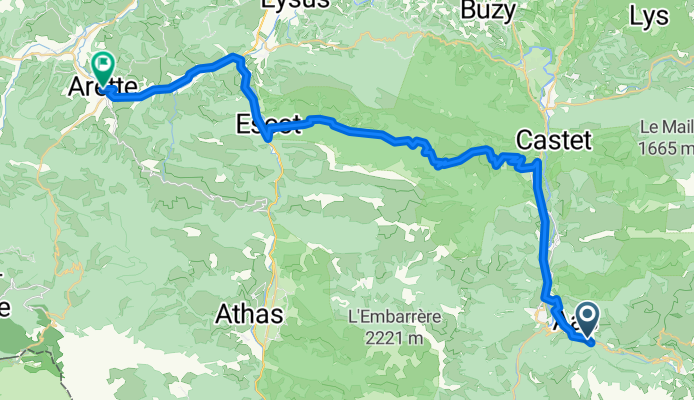
Transpirenaica: Eaux - Arette
Cycling route in Laruns, Nouvelle-Aquitaine, France
- 48.3 km
- Distance
- 1,441 m
- Ascent
- 1,868 m
- Descent

Transpirenaica: Arette - St. Jean Pied de Port
Cycling route in Arette, Nouvelle-Aquitaine, France
- 69 km
- Distance
- 734 m
- Ascent
- 862 m
- Descent

Transpirenaica: St Jean Port - St Jean Luz
Cycling route in Saint-Jean-Pied-de-Port, Nouvelle-Aquitaine, France
- 60.5 km
- Distance
- 806 m
- Ascent
- 953 m
- Descent