
My saved routes
A collection of 5 cycling routes, created by ED.
Overview
About this collection
This collection contains all routes that were previously saved.
- 5
- Routes
- -:--
- Duration
- 278.9 km
- Distance
- ---
- Avg. speed
- 3,688 m
- Ascent
- 3,663 m
- Descent
ED
created this 9 years ago
My saved routes
Routes in this collection
All 5 routes in this collection can be opened on the map or in the Bikemap App for more details, where you can adjust them in the route planner, or download them as GPX or KML file. Use them as a template for planning your own rides, or let Bikemap navigate you along them directly.

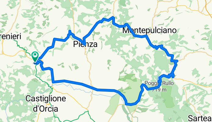
San Quirico Pienza Montepulciano San Quirico
Cycling route in San Quirico d'Orcia, Tuscany, Italy
None
(cloned from route 2002649)
- 59.6 km
- Distance
- 684 m
- Ascent
- 684 m
- Descent

Tegernsee-Valepp-Spitzingsattel-Schliersee-Tegernsee
Cycling route in Tegernsee, Bavaria, Germany
From Tegernsee via Rottach-Egern to Valepp and up to Spitzingsattel. From the saddle to Schliersee and back to Tegernsee.
- 55.4 km
- Distance
- 681 m
- Ascent
- 686 m
- Descent

Tegernsee-Valepp-Spitzingsattel-Schliersee-Tegernsee
Cycling route in Tegernsee, Bavaria, Germany
Von Tegernsee über Rottach-Egern nach Valepp und hoch auf den Spitzingsattel. Vom Sattel nach Schliersee und zurück nach Tegernsee.
(cloned from route 950642)
- 55.4 km
- Distance
- 681 m
- Ascent
- 686 m
- Descent

Gmund-Tegernsee-Rottach-Hagrain-Valepp-Spitzingsee-Spitzingsattel-Schliersee-Hausham-Gmund
Cycling route in Gmund am Tegernsee, Bavaria, Germany
- 48.9 km
- Distance
- 945 m
- Ascent
- 909 m
- Descent
San Quirico Pienza Montepulciano San Quirico
Cycling route in San Quirico d'Orcia, Tuscany, Italy
- 59.6 km
- Distance
- 697 m
- Ascent
- 698 m
- Descent