
My saved routes
A collection of 7 cycling routes, created by Sengor.
Overview
About this collection
This collection contains all routes that were previously saved.
- 7
- Routes
- -:--
- Duration
- 229.2 km
- Distance
- ---
- Avg. speed
- 4,523 m
- Ascent
- 4,118 m
- Descent

created this 9 years ago
My saved routes
Routes in this collection
All 7 routes in this collection can be opened on the map or in the Bikemap App for more details, where you can adjust them in the route planner, or download them as GPX or KML file. Use them as a template for planning your own rides, or let Bikemap navigate you along them directly.

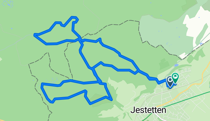
Reiattour
Cycling route in Jestetten, Baden-Wurttemberg, Germany
- 39.4 km
- Distance
- 615 m
- Ascent
- 601 m
- Descent

Feierabendrunde Altberg
Cycling route in Zürich (Kreis 10), Canton of Zurich, Switzerland
- 19.8 km
- Distance
- 388 m
- Ascent
- 388 m
- Descent

zoo-pfannenstiel
Cycling route in Zürich (Kreis 7) / Fluntern, Canton of Zurich, Switzerland
- 41.7 km
- Distance
- 800 m
- Ascent
- 795 m
- Descent

Zürich Hills Umrundung
Cycling route in Zürich (Kreis 6) / Unterstrass, Canton of Zurich, Switzerland
- 61.6 km
- Distance
- 1,647 m
- Ascent
- 1,267 m
- Descent

zum Aufwärmen, Seefeld - Trichterhausenmühle - Seefeld
Cycling route in Zürich (Kreis 8) / Seefeld, Canton of Zurich, Switzerland
- 10.1 km
- Distance
- 194 m
- Ascent
- 193 m
- Descent

Eglisau - Rorbas - Buch a.Irchel - Dorf - Flaach
Cycling route in Lottstetten, Baden-Wurttemberg, Germany
- 40.5 km
- Distance
- 606 m
- Ascent
- 606 m
- Descent
Die Ettenberg-Lakten-Lauter-Eichen-Runde
Cycling route in Jestetten, Baden-Wurttemberg, Germany
- 16.1 km
- Distance
- 274 m
- Ascent
- 268 m
- Descent