
90 (super)
Cycle Route 90 (Super)
A collection of 32 cycling routes.
Overview
About this collection
A road-focused cycling collection built around Route 90. Most segments are on asphalt and other paved surfaces, with a few short links on gravel or track. Expect an urban feel: plenty of main roads, quieter side streets, and stretches of dedicated cycleway. It’s easy to hop in anywhere and stitch together the parts you like for a quick spin or a longer loop.
Best with a road, hybrid, or light gravel bike. Go off-peak if you can—some sections are busy. Watch for junctions, buses, and pedestrian areas (slow down or walk when signed). If a stretch feels too hectic, there’s usually a calmer parallel street nearby.
Great for everyday rides, commuting practice, or steady training on mostly smooth tarmac. Bring lights, a bell, and 28–35 mm tires for comfort on the occasional rough patch.
- 32
- Routes
- -:--
- Duration
- 1,557.3 km
- Distance
- ---
- Avg. speed
- 6,789 m
- Ascent
- 7,563 m
- Descent
Cycle Route 90 (Super)
Routes in this collection
All 32 routes in this collection can be opened on the map or in the Bikemap App for more details, where you can adjust them in the route planner, or download them as GPX or KML file. Use them as a template for planning your own rides, or let Bikemap navigate you along them directly.

90: East Palatka → Saint Augustine Shores
Cycling route in East Palatka, Florida, United States
- 17.4 km
- Distance
- 29 m
- Ascent
- 31 m
- Descent

90: Interlachen to East Palatka
Cycling route in Interlachen, Florida, United States
- 42.8 km
- Distance
- 163 m
- Ascent
- 141 m
- Descent

90: Alachua to Interlachen
Cycling route in Alachua, Florida, United States
- 110.6 km
- Distance
- 472 m
- Ascent
- 460 m
- Descent

90: Alachua to Alachua
Cycling route in Alachua, Florida, United States
- 15.4 km
- Distance
- 3 m
- Ascent
- 17 m
- Descent

90 (Florida): Wellborn to High Springs
Cycling route in Wellborn, Florida, United States
- 90 km
- Distance
- 63 m
- Ascent
- 48 m
- Descent
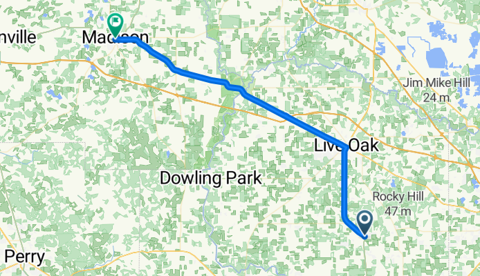
US 90: Madison to Wellborn
Cycling route in Madison, Florida, United States
- 69.6 km
- Distance
- 207 m
- Ascent
- 179 m
- Descent

Monticello to Madison (US 90)
Cycling route in Monticello, Florida, United States
- 47.9 km
- Distance
- 241 m
- Ascent
- 233 m
- Descent

90: Tallahassee to Monticello
Cycling route in Tallahassee, Florida, United States
- 54.9 km
- Distance
- 396 m
- Ascent
- 439 m
- Descent

USBR 90: Midway to Sneads
Cycling route in Midway, Florida, United States
- 52.3 km
- Distance
- 326 m
- Ascent
- 339 m
- Descent

US 90: Sneads to Chipley
Cycling route in Sneads, Florida, United States
- 61.4 km
- Distance
- 284 m
- Ascent
- 302 m
- Descent
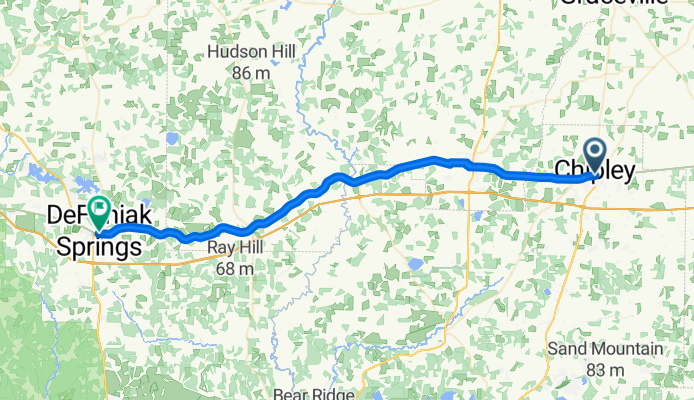
90: Chipley to DeFuniak Springs
Cycling route in Chipley, Florida, United States
- 60.2 km
- Distance
- 257 m
- Ascent
- 216 m
- Descent

90: DeFuniak Springs to Crestview
Cycling route in DeFuniak Springs, Florida, United States
- 45.1 km
- Distance
- 141 m
- Ascent
- 145 m
- Descent