
Saint-Jacques à Vélo
Saint-Jacques by Bike: Eure Valley
A collection of 12 cycling routes.
Overview
About this collection
Easygoing Camino vibes along the Eure River. This collection links the Saint‑Jacques by Bike sections through the Eure Valley, rolling between Normandy and Centre‑Val de Loire.
It’s mostly smooth sailing: plenty of paved lanes and cycleways, with a few short gravel bits and the occasional busy connector near towns. The profile is gently rolling—no big climbs, but the little ups and downs add up over a full day.
Expect classic river-valley scenery: towpaths, open fields, shady forests, stone villages, old mills, and the odd château popping into view. A touring or gravel bike is ideal; 32 mm+ tires keep the mixed surfaces comfy.
Great for a relaxed multi-day trip or picking off a stage or two. Bring basic lights for urban sections and be ready for wind across open stretches. Navigation is straightforward with a GPX and local bike-route signs.
If you’re linking into the wider Camino network, this is a calm, scenic way to keep the river at your side while you point the bars southwest.
- 12
- Routes
- -:--
- Duration
- 382.7 km
- Distance
- ---
- Avg. speed
- 1,773 m
- Ascent
- 1,761 m
- Descent
Saint-Jacques by Bike: Eure Valley
Routes in this collection
All 12 routes in this collection can be opened on the map or in the Bikemap App for more details, where you can adjust them in the route planner, or download them as GPX or KML file. Use them as a template for planning your own rides, or let Bikemap navigate you along them directly.

Saint-Jacques à Vélo par la vallée d'Eure: Dangé-Saint-Romain to Antran
Cycling route in Dangé-Saint-Romain, Nouvelle-Aquitaine, France
- 21 km
- Distance
- 35 m
- Ascent
- 46 m
- Descent

Saint-Jacques à Vélo: Sorigny → Dangé-Saint-Romain
Cycling route in Sorigny, Centre-Val de Loire, France
- 47 km
- Distance
- 240 m
- Ascent
- 188 m
- Descent
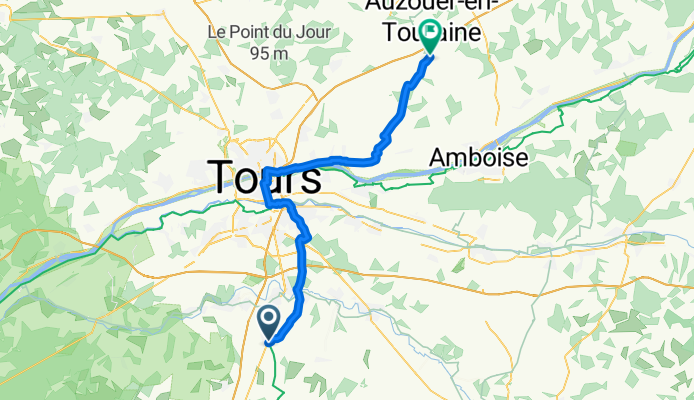
Saint-Jacques à Vélo: Reugny to Sorigny
Cycling route in Reugny, Centre-Val de Loire, France
- 50.2 km
- Distance
- 227 m
- Ascent
- 229 m
- Descent

Saint-Jacques à Vélo (vallée d’Eure): Château-Renault → Reugny
Cycling route in Château-Renault, Centre-Val de Loire, France
- 24.7 km
- Distance
- 254 m
- Ascent
- 197 m
- Descent

Saint-Jacques à Vélo par la vallée d'Eure: Vendôme - Château-Renault
Cycling route in Vendôme, Centre-Val de Loire, France
- 39.5 km
- Distance
- 248 m
- Ascent
- 303 m
- Descent

Saint-Jacques à Vélo par la vallée d'Eure: Morée to Vendôme
Cycling route in Morée, Centre-Val de Loire, France
- 21 km
- Distance
- 116 m
- Ascent
- 99 m
- Descent
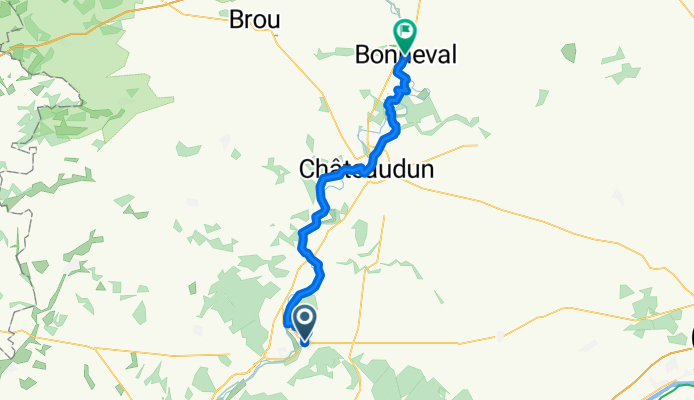
Bonneval to Morée - Saint-Jacques à Vélo (vallée d'Eure)
Cycling route in Bonneval, Centre-Val de Loire, France
- 47.9 km
- Distance
- 342 m
- Ascent
- 331 m
- Descent

Saint-Jacques à Vélo par la vallée d'Eure : Bailleau-le-Pin → Bonneval
Cycling route in Bailleau-le-Pin, Centre-Val de Loire, France
- 20.8 km
- Distance
- 57 m
- Ascent
- 25 m
- Descent

Saint-Jacques à Vélo: Nogent-le-Roi → Bailleau-le-Pin
Cycling route in Nogent-le-Roi, Centre-Val de Loire, France
- 62.7 km
- Distance
- 161 m
- Ascent
- 216 m
- Descent

Saint-Jacques à Vélo par la vallée d'Eure: Abondant → Nogent-le-Roi
Cycling route in Abondant, Centre-Val de Loire, France
- 20.4 km
- Distance
- 25 m
- Ascent
- 47 m
- Descent

Marcilly-sur-Eure to Bueil - Saint-Jacques à Vélo (vallée d'Eure)
Cycling route in Marcilly-sur-Eure, Normandy, France
- 23.2 km
- Distance
- 37 m
- Ascent
- 58 m
- Descent
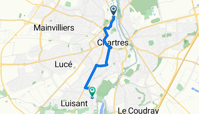
Luisant to Chartres – Saint-Jacques à Vélo (vallée d’Eure)
Cycling route in Luisant, Centre-Val de Loire, France
- 4.4 km
- Distance
- 32 m
- Ascent
- 23 m
- Descent