
Mur Cycle Path Left Bank (AT)
Murradweg – linkes Ufer (AT)
A collection of 12 cycling routes.
Overview
About this collection
This collection compiles left-bank sections of the Mur bike path (R2) in Austria. You mostly cycle on paved bike paths and quiet side roads, with short gravel and track passages. Ideal for trekking bikes, touring bikes, and e-bikes; usually also manageable with narrower tires.
The route follows the Mur closely through alpine valleys to the Styrian hills—mostly pleasantly flat, with occasional short undulations. Along the way, you’ll find floodplains, bridges, and lively towns (including Graz), as well as many spots for breaks by the water.
Signage is generally very good (R2). A GPX file helps with riverbank changes and detours. After rain, gravel sections can be softer; observe local notices during high water. Best time: spring to autumn. Perfect for leisure cycling, day stages, and relaxed multi-day tours along the Mur.
- 12
- Routes
- -:--
- Duration
- 311.3 km
- Distance
- ---
- Avg. speed
- 4,115 m
- Ascent
- 2,917 m
- Descent
Murradweg – linkes Ufer (AT)
Routes in this collection
All 12 routes in this collection can be opened on the map or in the Bikemap App for more details, where you can adjust them in the route planner, or download them as GPX or KML file. Use them as a template for planning your own rides, or let Bikemap navigate you along them directly.

Murradweg linkes Ufer: Sankt Lorenzen bei Knittelfeld – Sankt Lorenzen bei Scheifling
Cycling route in Sankt Lorenzen bei Knittelfeld, Styria, Austria
- 56.1 km
- Distance
- 612 m
- Ascent
- 447 m
- Descent
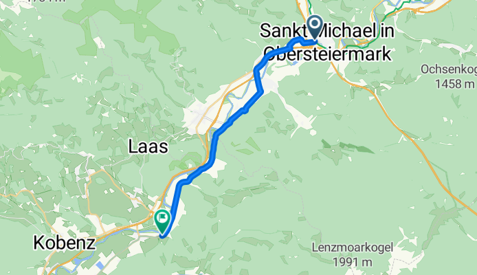
Murradweg linkes Ufer: Sankt Michael in Obersteiermark – Sankt Lorenzen bei Knittelfeld
Cycling route in Sankt Michael in Obersteiermark, Styria, Austria
- 14.4 km
- Distance
- 131 m
- Ascent
- 119 m
- Descent

Murradweg linkes Ufer – Abschnitt 3: Leoben – Sankt Michael in Obersteiermark
Cycling route in Leoben, Styria, Austria
- 11.5 km
- Distance
- 240 m
- Ascent
- 195 m
- Descent

Murradweg linkes Ufer – Abs. 4: Frohnleiten – Peggau
Cycling route in Frohnleiten, Styria, Austria
- 6.1 km
- Distance
- 60 m
- Ascent
- 56 m
- Descent

Murradweg linkes Ufer – Abs. 4: Peggau–Werndorf
Cycling route in Peggau, Styria, Austria
- 42.5 km
- Distance
- 202 m
- Ascent
- 316 m
- Descent

Murradweg linkes Ufer (AT): Spielfeld – Werndorf
Cycling route in Spielfeld, Styria, Austria
- 33.2 km
- Distance
- 103 m
- Ascent
- 42 m
- Descent

Murradweg linkes Ufer – Abs. 6: Mureck–Spielfeld
Cycling route in Mureck, Styria, Austria
- 7.5 km
- Distance
- 38 m
- Ascent
- 44 m
- Descent

Murradweg linkes Ufer – Abschnitt 6: Gornja Radgona – Mureck
Cycling route in Gornja Radgona, Gornja Radgona, Slovenia
- 35 km
- Distance
- 119 m
- Ascent
- 75 m
- Descent
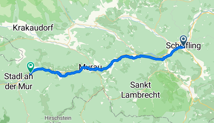
Murradweg linkes Ufer – Abs. 2: St. Ruprecht-Falkendorf → Sankt Lorenzen bei Scheifling
Cycling route in St. Ruprecht-Falkendorf, Styria, Austria
- 35.9 km
- Distance
- 752 m
- Ascent
- 647 m
- Descent

Murradweg linkes Ufer – Abs. 2: Stadl an der Mur → St. Ruprecht-Falkendorf
Cycling route in Stadl an der Mur, Styria, Austria
- 9.9 km
- Distance
- 166 m
- Ascent
- 106 m
- Descent

Murradweg linkes Ufer (AT) – Abschnitt 1: Muhr – Stadl an der Mur
Cycling route in Muhr, Salzburg, Austria
- 47.9 km
- Distance
- 833 m
- Ascent
- 560 m
- Descent

Murradweg linkes Ufer – Zederhaus – Muhr
Cycling route in Zederhaus, Salzburg, Austria
- 11.4 km
- Distance
- 859 m
- Ascent
- 311 m
- Descent