
Trans Bavarian Forest South Route
Trans Bayerwald Südroute
A collection of 14 cycling routes.
Overview
About this collection
The Trans Bayerwald South route cuts across the Bayerwald – lots of nature, long climbs, and plenty of offroad. Gravel, forest, and meadow trails dominate, with sections on quiet secondary roads; dedicated bike paths are rare. Expect significant elevation gain and sometimes rough terrain – ideal for MTB or a sturdy gravel bike with wide tires. Perfect as a multi-day bikepacking tour or a sporty challenge in one go. Along the way, you'll encounter dense forests, wide vistas, and peaceful villages for relaxing breaks. Plan stages flexibly according to fitness and daylight, and pack enough provisions and rain gear – weather in the Bayerwald can change quickly. Those who love gravel will get the full dose of nature and flow here.
- 14
- Routes
- -:--
- Duration
- 370 km
- Distance
- ---
- Avg. speed
- 10,464 m
- Ascent
- 10,838 m
- Descent
Trans Bayerwald Südroute
Routes in this collection
All 14 routes in this collection can be opened on the map or in the Bikemap App for more details, where you can adjust them in the route planner, or download them as GPX or KML file. Use them as a template for planning your own rides, or let Bikemap navigate you along them directly.
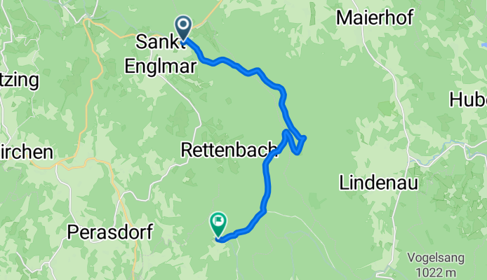
Trans Bayerwald Südroute Etappe 5: Sankt Englmar – Böbrach
Cycling route in Sankt Englmar, Bavaria, Germany
- 11.7 km
- Distance
- 242 m
- Ascent
- 320 m
- Descent

Trans Bayerwald Südroute Etappe 5
Cycling route in Böbrach, Bavaria, Germany
- 78.7 km
- Distance
- 2,933 m
- Ascent
- 2,684 m
- Descent

Trans Bayerwald Südroute Etappe 6
Cycling route in Bischofsmais, Bavaria, Germany
- 17.2 km
- Distance
- 561 m
- Ascent
- 434 m
- Descent

Trans Bayerwald Südroute Etappe 6
Cycling route in Schaufling, Bavaria, Germany
- 46.9 km
- Distance
- 1,404 m
- Ascent
- 1,551 m
- Descent

Trans Bayerwald Südroute Etappe 7: Passau – Aicha vorm Wald
Cycling route in Passau, Bavaria, Germany
- 33.4 km
- Distance
- 707 m
- Ascent
- 691 m
- Descent
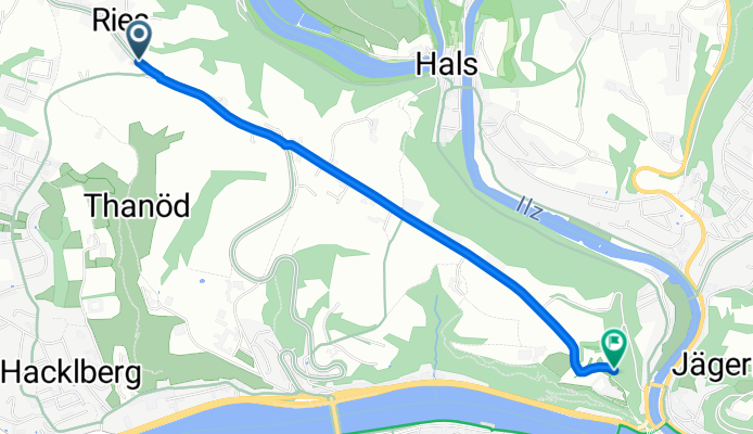
Trans Bayerwald Südroute Etappe 7
Cycling route in Passau, Bavaria, Germany
- 2.5 km
- Distance
- 11 m
- Ascent
- 59 m
- Descent

Trans Bayerwald Südroute Etappe 4
Cycling route in Sankt Englmar, Bavaria, Germany
- 36.9 km
- Distance
- 1,097 m
- Ascent
- 1,362 m
- Descent

Trans Bayerwald Südroute Etappe 4
Cycling route in Falkenstein, Bavaria, Germany
- 4.6 km
- Distance
- 104 m
- Ascent
- 171 m
- Descent

Trans Bayerwald Südroute Etappe 3
Cycling route in Falkenstein, Bavaria, Germany
- 3.2 km
- Distance
- 78 m
- Ascent
- 72 m
- Descent

Trans Bayerwald Südroute Etappe 3
Cycling route in Falkenstein, Bavaria, Germany
- 49.7 km
- Distance
- 932 m
- Ascent
- 1,042 m
- Descent

Trans Bayerwald Südroute Etappe 2: Stamsried – Thanstein
Cycling route in Stamsried, Bavaria, Germany
- 29.5 km
- Distance
- 996 m
- Ascent
- 866 m
- Descent

Trans Bayerwald Südroute Etappe 2: Thanstein – Rötz
Cycling route in Thanstein, Bavaria, Germany
- 7.1 km
- Distance
- 206 m
- Ascent
- 344 m
- Descent