
Rhein–Hirzel–Linth
Rhine–Hirzel–Linth
A collection of 6 cycling routes.
Overview
About this collection
A scenic link-up from the Rhine to the Hirzel ridge and down to the Linth plain — classic Swiss variety in one collection. Expect a rolling mix of riverbanks, farm roads, and hill country with big views toward the Alps around Hirzel. Most of it is smooth and fast: largely paved/asphalt, with just a few short gravel bits (roughly a couple of kilometers) and the odd cobbles or paving stones. Way types lean heavily toward quiet roads and cycleways, with some tracks and the occasional short busy stretch. Climbing stacks up to about 1,000 m across the full set, with punchy ramps on Hirzel and gentler cruising along the Rhine and Linth. It rides well on a road bike; 28–32 mm tires make the gravel patches a non-issue. Start anywhere — the routes connect well between towns, and you can mix shorter river segments with the hillier Hirzel options. Bring layers (ridge winds can be cooler) and lights for visibility through shaded forest lanes. Coffee and bakery stops are easy to find in villages en route. If you prefer all tarmac, it’s simple to detour around the brief gravel and steps. For a longer day, link multiple segments for a Rhine-to-Linth traverse; for something lighter, spin a flat out-and-back along the Linth plain. Either way, it’s a great taste of northern Switzerland on two wheels.
- 6
- Routes
- -:--
- Duration
- 103.2 km
- Distance
- ---
- Avg. speed
- 1,027 m
- Ascent
- 1,032 m
- Descent
Rhine–Hirzel–Linth
Routes in this collection
All 6 routes in this collection can be opened on the map or in the Bikemap App for more details, where you can adjust them in the route planner, or download them as GPX or KML file. Use them as a template for planning your own rides, or let Bikemap navigate you along them directly.

Rhein–Hirzel–Linth Etappe 1: Zürich Oerlikon → Glattfelden
Cycling route in Zürich (Kreis 11) / Oerlikon, Canton of Zurich, Switzerland
- 25 km
- Distance
- 330 m
- Ascent
- 245 m
- Descent
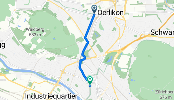
Rhein-Hirzel-Linth - Etappe 1
Cycling route in Zürich (Kreis 6) / Unterstrass, Canton of Zurich, Switzerland
- 2.5 km
- Distance
- 22 m
- Ascent
- 28 m
- Descent
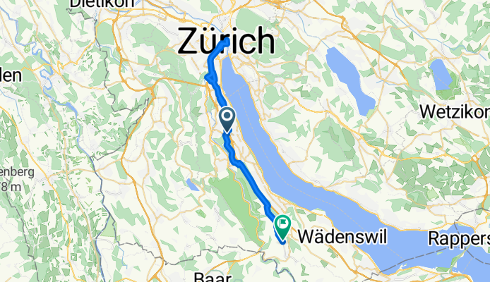
Rhein–Hirzel–Linth Etappe 2: Horgen (Allmend) – Adliswil (Tal)
Cycling route in Horgen / Allmend, Canton of Zurich, Switzerland
- 31.6 km
- Distance
- 426 m
- Ascent
- 253 m
- Descent

Rhein-Hirzel-Linth - Etappe 2
Cycling route in Wädenswil / Hangenmoos, Canton of Zurich, Switzerland
- 14 km
- Distance
- 110 m
- Ascent
- 366 m
- Descent

Rhein-Hirzel-Linth - Etappe 3
Cycling route in Freienbach, Canton of Schwyz, Switzerland
- 4.3 km
- Distance
- 63 m
- Ascent
- 69 m
- Descent

Rhein–Hirzel–Linth, Etappe 3: Altendorf–Niederurnen
Cycling route in Altendorf, Canton of Schwyz, Switzerland
- 25.7 km
- Distance
- 76 m
- Ascent
- 72 m
- Descent