
Stredné Plachtince
A collection of 10 cycling routes, created by Ďusi.
Overview
About this collection
This route collection contains 10 cycling routes with a total length of 410.8 km.
- 10
- Routes
- 24:59 h
- Duration
- 410.8 km
- Distance
- 16.4 km/h
- Avg. speed
- 4,883 m
- Ascent
- 4,902 m
- Descent
created this 8 months ago
Stredné Plachtince
Routes in this collection
All 10 routes in this collection can be opened on the map or in the Bikemap App for more details, where you can adjust them in the route planner, or download them as GPX or KML file. Use them as a template for planning your own rides, or let Bikemap navigate you along them directly.

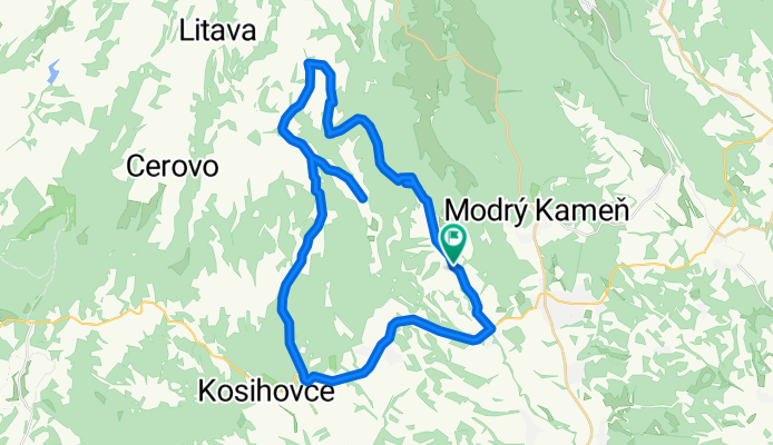
Stredné Plachtince - Čebovská Bukovina - Sucháň - Stredné Plachtince
Cycling route in Veľký Krtíš, Banská Bystrica Region, Slovakia
- 53.8 km
- Distance
- 870 m
- Ascent
- 872 m
- Descent

Stredné Plachtince - Čebovce - Slovenské Ďarmoty - Stredné Plachtince
Cycling route in Veľký Krtíš, Banská Bystrica Region, Slovakia
- 43.6 km
- Distance
- 326 m
- Ascent
- 328 m
- Descent
Stredné Plachtince - Záhorce a späť
Cycling route in Veľký Krtíš, Banská Bystrica Region, Slovakia
- 31 km
- Distance
- 86 m
- Ascent
- 89 m
- Descent
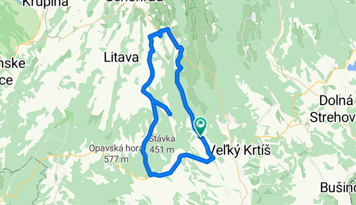
Stredné Plachtince - lesom Trúbiaci kameň a Sucháň - pod Vysielač a cez Čebovce späť
Cycling route in Veľký Krtíš, Banská Bystrica Region, Slovakia
- 41.1 km
- Distance
- 754 m
- Ascent
- 757 m
- Descent
Stredné Plachtince - lesom Dačov Lom a Sucháň - pod Vysielač a cez Čebovce späť
Cycling route in Veľký Krtíš, Banská Bystrica Region, Slovakia
- 49.4 km
- Distance
- 960 m
- Ascent
- 963 m
- Descent
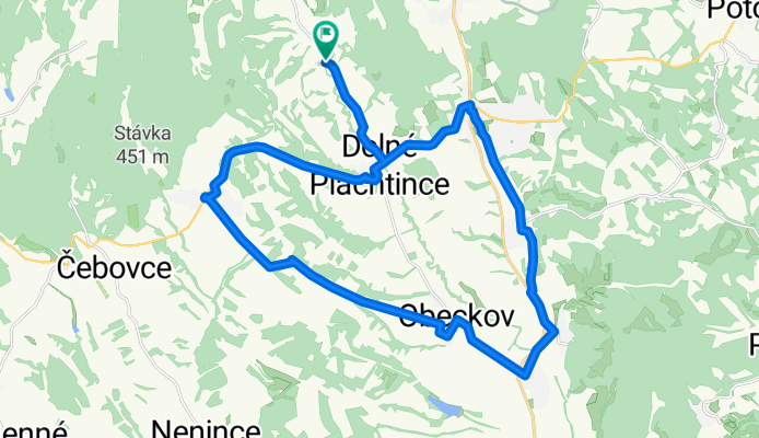
Str. Plachtince - Kosihovce - Trebušovce - Lesenice - Ďarmoty - Str. Plachtince
Cycling route in Veľký Krtíš, Banská Bystrica Region, Slovakia
- 49.4 km
- Distance
- 307 m
- Ascent
- 309 m
- Descent
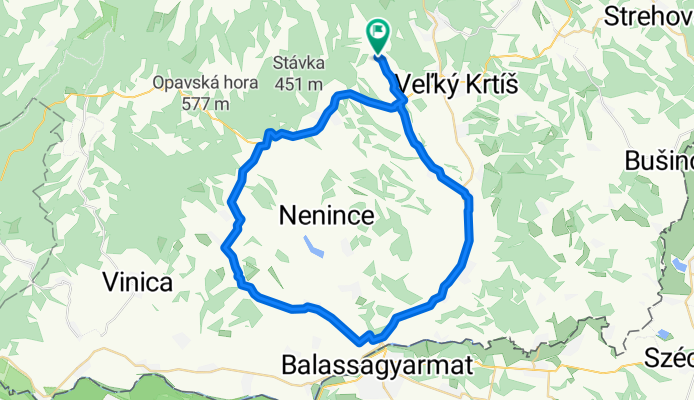
Str. Plachtince - Čebovce - Nenince - Ďarmoty - Str. Plachtince
Cycling route in Veľký Krtíš, Banská Bystrica Region, Slovakia
- 43.4 km
- Distance
- 289 m
- Ascent
- 291 m
- Descent
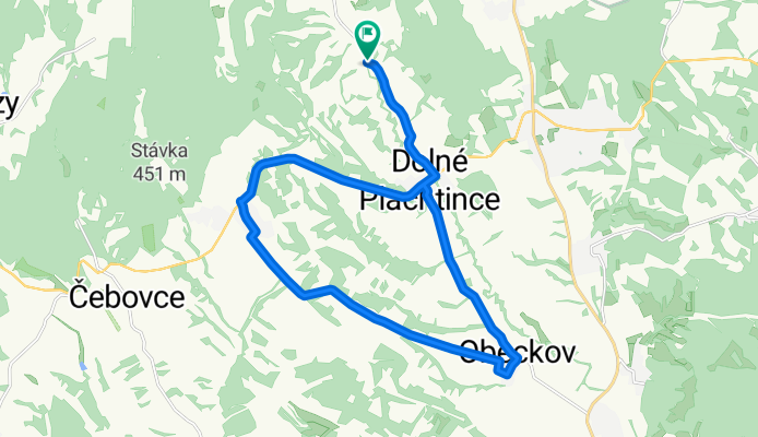
Str. Plachtince - Príbelce - Škriavnik - Obeckov - Str. Plachtince
Cycling route in Veľký Krtíš, Banská Bystrica Region, Slovakia
- 21.4 km
- Distance
- 201 m
- Ascent
- 202 m
- Descent
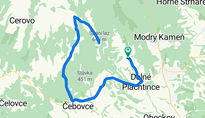
Str. Plachtince - Čebovce - Španí laz - Str. Plachtince
Cycling route in Veľký Krtíš, Banská Bystrica Region, Slovakia
- 47.6 km
- Distance
- 824 m
- Ascent
- 826 m
- Descent
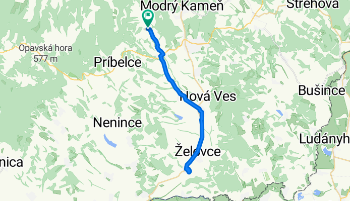
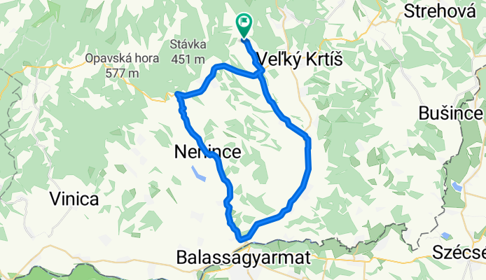
Stredné Plachtince - Škriavnik - Nová Ves - Malý Krtíš - Veľký Krtíš . Stredné Plachtince
Cycling route in Veľký Krtíš, Banská Bystrica Region, Slovakia
- 30 km
- Distance
- 266 m
- Ascent
- 267 m
- Descent